Sold2017Map of Conneticut by HardestyItem: Map of Conneticut by Hardesty Date: 1883 Dimensions: 14.5 x 10.5 in No Reserve: This lot starts at $1 and has no reserve as a courtesy so that collectors can determine the true market value on tSee Sold Price
Sold2022Pub. 1885, First Edition, Illustrated Clour Plates, Maps, "Hardesty's Military Historical and"Hardesty's Military Historical and Geographical Illustrated: Special Military History of Ohio, Giving Its Part in the Indian Wars, Border Annals, War 1812, Mexican War and the War of the Rebellion",See Sold Price
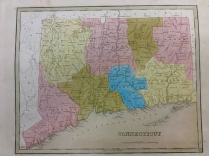
2017Bradford: Antique Map of Conneticut, 1838Title/Content of Map: Conneticut by Bradford Date Printed: 1838/1841 Cartographer: Thomas G. Bradford Material/Medium: Paper Size: 13" x 16 1/2" Hand colored. A General Atlas of the World with a SeparSee Sold Price
Sold2022Scarce Hardesty map of Southwest US, 1875Great map of the West, noting copper, silver and gold regions throughout southern Arizona and New Mexico. “Map of Colorado, Utah, New Mexico and Arizona,” by J. David Williams. Published 1875 by HSee Sold Price
Sold20171882 Historical Hand Atlas, H. H. Hardesty Map1882 Historical Hand Atlas Illustrated, H. H. Hardesty 11.5 X 15. This Hard-to-find Atlas Has Been Rebound—it Will Look Great on Your Shelf. Several State Maps (texas/indian Territory, California/laSee Sold Price
Sold2022Uncommon Hardesty map of upper Northwest US, 1875Nice, elusive early map of northwest territories with vintage original full hand coloring. Idaho and Washington still seen as Territories. ?Map of Washington Oregon and Idaho? published 1875 by HigginSee Sold Price
Sold2017Hardesty: Map of Oregon, 1883Map: Oregon Maker: Hardesty 1883 21 x 14.75 in Please note that this lot has a confidential reserve. When you leave a bid in advance of the auction, submit your maximum. Jasper52 will bid on your behaSee Sold Price
Sold20221883 Hardesty Map of Pennsylvania -- Map of PennsylvaniaTitle: 1883 Hardesty Map of Pennsylvania -- Map of Pennsylvania Cartographer: H Hardesty Year / Place: 1883, Chicago Map Dimension (in.): 12.8 X 19.4 in. This is an excellent map of Pennsylvania. GreaSee Sold Price
Sold2017Hardesty Map of Nebraska, 1883Title: 1883 Hardesty Map of Nebraska Cartographer: H Hardesty Published: 1883, Chicago Measurements: 12.8 X 18.8 in. Map of Nebraska. A nice county map of Nebraska. Detailed with settlements, and railSee Sold Price
Sold20191883 Hardesty Map of Northern Dakota -- Map ofReserve Reduced! Title/Content of Map: 1883 Hardesty Map of Northern Dakota -- Map of Dakota-Northern Portion Date: 1883, Chicago Cartographer: H. Hardesty Size: 12.7 X 18.5 in. A nice county map of tSee Sold Price
Sold2017Hardesty: Map of Jerusalem, 18831883 h/c map of Jerusalem published by H. H. Hardesty. 9.5 x 13.5. Detailed topographic map of the center of the world’s religions. Nicely centered with no apparent faults. Please note that thisSee Sold Price
Sold20181882 Hardesty Atlas of the USA, Bible Geography andTitle/Content of Map: 1882 Hardesty Atlas of the USA, Bible Geography and Lawrence Co., Ohio -- Historical Hand-Atlas Illustrated, Containing Large Scale Copper Plate Maps of Each State… Together wiSee Sold Price
Sold2022Map of Washington.Title: Map of Washington. Cartographer: RAND, MCNALLY & CO. Publication Date: 1885 Publisher: H.H. HARDESTY & CO. Height: 13 Width: 19.75 Ornamental border. 254-255. Grid map from Hardesty's HistoricaSee Sold Price
Sold2017Hardesty: Antique Map Nebraska Dakota Montana WyomingScarce 1875 Hardesty map of Nebraska, Dakota, Montana & Wyoming. From the scarce Jones and Hamilton Illustrated Historical Atlas of the World Illustrated. Large format hand-colored map shows TerritorySee Sold Price
Sold2017J. H. Colton: Wyoming MapJ. H. Colton Map Wyoming Hardesty 1883 Map, 14.5 x 10.75 in Please note that this lot has a confidential reserve. When you leave a bid in advance of the auction, submit your maximum. Jasper52 will bidSee Sold Price
Sold2017Hardesty: Antique Map of Texas, 1875Large and fully hand-colored map from the very scarce 1875 Jones and Hamilton Historical Atlas of the World Illustrated. Colored by county. This is a quality map, lithographed on good paper. DepictedSee Sold Price
Sold2017Hardesty: Antique Map of Oregon, 1883Title: Map of Oregon by Hardesty Date: 1883 Medium: Wax Engraving Dimensions (in): 21 x 14.5 Condition: Excellent Condition No Reserve: This lot starts at $1 and has no reserve as a courtesy so that cSee Sold Price
Sold2017Hardesty: Antique Map of Wyoming, 1883Title: Map of Wyoming by Hardesty Date: 1883 Medium: Wax Engraving Dimensions (in): 14.5 x 10.5 Condition: Great Condition No Reserve: This lot starts at $1 and has no reserve as a courtesy so that coSee Sold Price
Sold2017Hardesty: Antique Map of Arizona, 1883Title: Map of Arizona by Hardesty Date: 1883 Medium: Wax Engraving Dimensions (in): 21 x 14.5 Condition: Excellent Condition No Reserve: This lot starts at $1 and has no reserve as a courtesy so thatSee Sold Price
Sold2017Hardesty's World Map, 1883Map of the World by Hardesty 1883 Size: 20.75 x 14.5 in No Reserve: This lot starts at $1 and has no reserve as a courtesy so that collectors can determine the true market value on this authentic itemSee Sold Price
Sold2017Hardesty: Antique Map of Colorado, 1883Title: Map of Colorado by Hardesty Date: 1883 Medium: Wax Engraving Dimensions (in): 21 x 14.5 Condition: Great Condition No Reserve: This lot starts at $1 and has no reserve as a courtesy so that colSee Sold Price
Sold2017Hardesty: Antique Map of Alaska, 1883Title: Map of Alaska by Hardesty Date: 1883 Medium: Wax Engraving Dimensions (in): 11 x 14.5 Condition: Great Condition No Reserve: This lot starts at $1 and has no reserve as a courtesy so that colleSee Sold Price
Sold2017Hardesty: Antique Map of Nebraska, 1883Title: Map of Nebraska by Hardesty Date: 1883 Medium: Wax Engraving Dimensions (in): 21x 14.5 Condition: Excellent Condition No Reserve: This lot starts at $1 and has no reserve as a courtesy so thatSee Sold Price
Sold2017Hardesty: Antique Map of Dakota-Southern Portion, 1883Title: Map of Dakota-Southern Portion by Hardesty Date: 1883 Medium: Wax Engraving Dimensions (in): 21 x 14.5 Condition: Excellent Condition No Reserve: This lot starts at $1 and has no reserve as a cSee Sold Price
May 29Cedarburg Auction & Appraisals LLCSet of Four Maps Showing All of Spain and Portugal$375(2 bids)
Jun 07Freeman's | Hindman[MAP]. TODESCHI, Pietro. [Nova et Acurata Totius Americae Tabula auct. G.I. Blaeu] America quarta$5,000
May 29Cedarburg Auction & Appraisals LLCRare 1877 Double sided map of Milwaukee and Wisconsin$40(4 bids)
Jun 07Freeman's | Hindman[MAP]. ORTELIUS, Abraham. Americae Sive Novi Orbis, Nova Descriptio. 1573.$1,000(1 bid)
6 days LeftArarity AuctionsThomson's 1817 Hand Colored Map Comparative Heights of the World's Great Mountains$50
1 day LeftThomaston Place Auction GalleriesCOLLECTION OF TRAVEL EPHEMERA, BROCHURES, BOOKLETS, MAPS 1900-1950$100
Featured12 hrs LeftJasper521814 Aaron Arrowsmith map. Israelites from Egypt to Canaan through the desert of Arabia Petraea$130


![[MAP]. TODESCHI, Pietro. [Nova et Acurata Totius Americae Tabula auct. G.I. Blaeu] America quarta (1 of 1)](https://p1.liveauctioneers.com/197/329395/177650542_1_x.jpg?height=282&quality=70&version=1715364962)


![[MAPS]. A group of 3 engraved maps, most with hand-coloring. (1 of 4)](https://p1.liveauctioneers.com/197/328642/177014805_1_x.jpg?height=282&quality=70&version=1714760103)
![[MAP]. ORTELIUS, Abraham. Americae Sive Novi Orbis, Nova Descriptio. 1573. (1 of 2)](https://p1.liveauctioneers.com/197/329395/177650534_1_x.jpg?height=282&quality=70&version=1715364962)


