Sold2021Large scale map of Paris in oak frameLarge scale Map of Paris ("Carte Particuliere des Environs de Paris") in oak frame. Originally designed in 1674 by Francois de La Pointe for the Royal Academy. This version dates to early 20th centurySee Sold Price
Sold2018Bellin: Maps/Views of Aztec & Colonial Mexico CityTitle/Content of Map: Carte des Environs de la Ville de Mexico / Ancien Mexico [and on a second sheet] Nouveau Mexico / Carte du lac de Mexico et de ses Environs Cartographer: Bellin / Chedel Place &See Sold Price
Sold2017Bellin: Antique Map of Mexico City Region, 1754Map: Carte des Environs de la Ville de Mexico Cartographer: Bellin Place & Date: Paris / 1754 Size: 6 3/4" x 8 3/4" Condition: outline color; overall age toning Bellin's detailed map of the environs oSee Sold Price
Sold2016Environs De Cambray Bappaumes, St Quentin. Jean CovensCarte Particuliere Des Environs De Cambray Bappaumes, St Quentin, Perone Maker: Covens, Jean. Origin: Amsterdam, 1730. Medium: Original copper plate engraving with later hand-coloring. Sheet size: 21See Sold Price
Sold2016Environs De Cambray, Bappaumes, St. Quentin, PeroneCarte Particuliere Des Environs De Cambray, Bappaumes, St. Quentin, Perone Maker: Fricx, Eugne Henri. Origin: Brussels, 1710. Medium: Original engraving with early hand-coloring Sheet size: 24 x 21 inSee Sold Price
Sold20221754 Bellin Map of Mexico City and Surroundings -- Carte des Environs de la Ville de MexicoTitle: 1754 Bellin Map of Mexico City and Surroundings -- Carte des Environs de la Ville de Mexico Cartographer: J Bellin Year / Place: 1754, Paris Map Dimension (in.): 8 X 6.4 in. This a very nice maSee Sold Price
Sold2020Carte du Lac de Mexico' City Tenochtitlan Lake Texcoco.TITLE/CONTENT OF MAP: 'Carte du Lac de Mexico, et de ses Environs, lors de la Conquête des Espagnols [Map of Lake Texcoco and its environs, at the time of the Spanish conquest]' The location of MexicSee Sold Price
Sold2023Map, Tabula Geographica Mexicae et FloridaeCarte Du Mexique Et De La Floride Des Terres Angloise Et Des Isles Antilles / Du Course Et Des Environs De La Riviere De Mississip; Covens and Mortier; Amsterdam 1722; mounted on board. 21 1/8" high,See Sold Price
Sold2017Bellin: Map of Mexico City & Lake Texcoco, 1758Map Title: 'Carte du Lac de Mexique, et de ses Environs. Lors de le Conqueste des Espagnols Pour servir à l'Histoire Générale des Voyages' A map of Spanish colonial Mexico City on an island in LakeSee Sold Price
Sold20201757 Bellin Carte Du Lac De Mexico1757 Map by Jacques Bellun entitled "Carte Du Lac De Mexico Et De Ses Environs Lors de la Conqueste des Espagnols", printed at Paris. From his work "L'Histoire Generale des Voyages", Fine, measures 7See Sold Price
Sold20211754 Bellin Map of Mexico City and Lakes -- Carte duTitle: 1754 Bellin Map of Mexico City and Lakes -- Carte du Lac de Mexico, et de ses Environs Lors de la Conqueste des Espagnols Cartographer: J Bellin Year / Place: 1754, Paris Map Dimension (in.): 8See Sold Price
Sold2024Barthelemy, Jean 1790 Map. Greece - Plan des Environs d'Athenes AthensCopper Engraved Map Published 1790, Paris for "Recueil de Cartes Geographiques, Plans, Vues et Medailles de L'Ancienne Grece, Relatifs Au Voyage du Jeune Anacharsis" by Jean Jacques Barthelemy. CentreSee Sold Price
Sold2020Carte Des Environs De La Ville De Mexico PourTitle: Carte Des Environs De La Ville De Mexico Pour L'histoire Gene. Des Voyages. 1754. Publication Date: 1754 Cartographer: BELLIN, JACQUES NICOLAS, ELDER (1703-1772) Publisher: DIDOT Brief DescriptSee Sold Price
Sold2018Depot de la Marine: Hispaniola, Year XI (1802–03)Map: Carte Particulière de l'Isle de Saint Domingue Cartographer: Dépôt général de la Marine/Sorrel Place/Date: Paris / 1803 Size: 36" x 22" Condition: b&w; light overall age toning; minor browniSee Sold Price
Sold2017Bellin: Antique Map of Maluku Islands, Indonesia, 1757Title/Content of Map: 'Carte Particuliere des Isles Moluques. ' Maluku Islands - Halmahera - Ternate - Pulau Tidore - Makian Island - Bacan - Palamea Date Printed: 1757 Image Size: Approx 23.5 x 16.5cSee Sold Price
Sold2016Environs D'Avesnes Landrecy. Jean CovensCarte Particuliere Des Environs D'Avesnes Landrecy Maker: Covens, Jean Origin: Amsterdam, 1730 Medium: Original copper plate engraving with later hand-coloring Sheet size: 18 x 22 in. No Reserve: ThisSee Sold Price
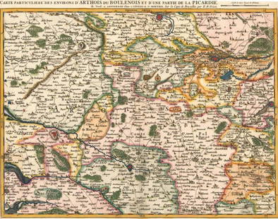
Sold2016Environs d'Arthois du Boulenois. Eugène Henry FricxCarte Particuliere des Environs d'Arthois du Boulenois Maker: Fricx, Eugene Henry. Origin: Amsterdam, circa 1745. Medium: Original copper engraving with later hand-coloring. Sheet size: 21 x 24 1/2 inSee Sold Price
Sold2018Bellin: Two Maps of Robinson Crusoe Island, ChileMap: Carte Particuliere de l'Isle de Juan Fernandes [and on a separate sheet] Coste du Nord Est de l'Isle de Juan Fernandez [Robinson Crusoe Island] Cartographer: Bellin Place/Date: Paris / 1754/1760See Sold Price
Sold2019Carte des Provinces de Nicaragua & Costa Rica'. CentralTITLE/CONTENT OF MAP: 'Carte des Provinces de Nicaragua et Costa Rica [Map of the provinces of Nicaragua and Costa Rica]' DATE PRINTED: 1754 IMAGE SIZE: Approx 21.5 x 18.0cm, 8.5 x 7 inches (Medium) TSee Sold Price
Sold2017Bellin: Antique Map of Southeast Asia, 1750Map: Carte Des Royaume De Siam, De Tunquin. Pegu, Ava, Aracan, &C. Publication Date: 1750 Authors: DIDOT, BELLIN, JACQUES NICOLAS, ELDER (1703-1772) Publisher: DIDOT Size: Quarto – 10.75 H x 10.80 WSee Sold Price
Sold2016J. Bellin: Map of the West Coast of India, 1750Map: Carte des Costes de Perse, Gusarat, et Malabar. Tiree de la Carte Francoise de l'Ocean Oriental Maker: J. Bellin Date: 1750 Size: 9.7 x 8 inches This is a very attractive chart map of the west coSee Sold Price
Sold2018Chanlaire & Mentelle: Map of Hispaniola & Jamaica, 1798Title/Content of Map: Carte des Isles de la Jamaique et de St. Domingue Cartographer: Chanlaire & Mentelle / Tardieu Place & Date: Paris / 1798 Size: 16 3/4" x 13" Condition: outline color; light browSee Sold Price
Sold2016Pierre van der Aa: Belgium 1713Map: Carte des Comte de Hainaut de Namur et de Cambresis (Belgium) Maker: Pieter van der Aa Publishing: Leiden, Netherlands Date: 1713 Size: 9 x 12 inches Medium: Copper engraving with later hand coloSee Sold Price
Sold2018Bellin: Antique Map of Venezuela, Trinidad, 1754Title/Content of Map: Carte des Provinces de Caracas, Comana, et Paria Cartographer: Bellin Place & Date: Paris / 1754/1760 Size: 12" x 8" Condition: b&w; overall age toning and some spotting; a lightSee Sold Price
4 days LeftJasper521719 Chatelain Map of Russian Empire -- Carte Generale des Etats du Czar Empereur de Moscovie…$320
5 days LeftJasper52Carte des Provinces de Tierra Firme, Darien…' Panama Colombia. BELLIN 1756 map$75
5 days LeftJasper52Cartagène, Ste. Marthe et Venezuela'. Colombia. Cartagena. BELLIN 1754 map$80
5 days LeftJasper52Tabasco, Chiapa, Verapaz, Guatimala, Honduras & Yucatan' Mexico BELLIN 1754 map$85
4 days LeftJasper521719 Chatelain Map of the Adriatic and Venice Republic -- Carte de Geographie des Differents Etats$190
Featured5 days LeftJasper52Carte de Colombie et des Guyanes. Colombia Venezuela Guianas. LAPIE 1828 map$100
4 days LeftJasper521760 Maire/Leclerk Map of Eastern Belgium and Liege -- Carte De La Principaute De Liege Et De Ses$500
Jun 07Freeman's | HindmanBELLIN, Jacques-Nicolas. Carte Reduite de L'Ocean Oriental ou Mer Des Indies. Paris, 1757. Second$150
Jun 06BonhamsCÉSAR (CÉSAR BALDACCINI) (1921-1998) Portrait de compression de cartes de garantie Car...€4,000
5 days LeftJasper52Partie méridionale Du Bresil… River Plate basin Brazil Uruguay. BONNE 1780 map$25
5 days LeftJasper52Carte du Nouveau Royaume de Grenade… Colombia Venezuela Guyana. BONNE 1780 map$35
Jun 02Gold Coast Auctioneers17th-19th c. French Wall Art Collection Map City Sea Scapes Scenes etc.$50
Jun 08Leon GalleryPhilippe de Pretot, Etienne Andre (c. 1710 - 1787) and William Walton - Carte de Canal des Isles₱30,000


![Bellin: Maps/Views of Aztec & Colonial Mexico City: Title/Content of Map: Carte des Environs de la Ville de Mexico / Ancien Mexico [and on a second sheet] Nouveau Mexico / Carte du lac de Mexico et de ses Environs Cartographer: Bellin / Chedel Place &](https://p1.liveauctioneers.com/5584/114563/58815203_1_x.jpg?height=310&quality=70&version=1514941693)


![Carte du Lac de Mexico' City Tenochtitlan Lake Texcoco.: TITLE/CONTENT OF MAP: 'Carte du Lac de Mexico, et de ses Environs, lors de la Conquête des Espagnols [Map of Lake Texcoco and its environs, at the time of the Spanish conquest]' The location of Mexic](https://p1.liveauctioneers.com/5584/182355/91727366_1_x.jpg?height=310&quality=70&version=1603285541)


![Bellin: Two Maps of Robinson Crusoe Island, Chile: Map: Carte Particuliere de l'Isle de Juan Fernandes [and on a separate sheet] Coste du Nord Est de l'Isle de Juan Fernandez [Robinson Crusoe Island] Cartographer: Bellin Place/Date: Paris / 1754/1760](https://p1.liveauctioneers.com/5584/121579/61869311_1_x.jpg?height=310&quality=70&version=1525825025)
![Carte des Provinces de Nicaragua & Costa Rica'. Central: TITLE/CONTENT OF MAP: 'Carte des Provinces de Nicaragua et Costa Rica [Map of the provinces of Nicaragua and Costa Rica]' DATE PRINTED: 1754 IMAGE SIZE: Approx 21.5 x 18.0cm, 8.5 x 7 inches (Medium) T](https://p1.liveauctioneers.com/5584/140883/71384644_1_x.jpg?height=310&quality=70&version=1556665642)


