Sold2023Map of 1859 Switzerland by ColtonTitle: Map of 1859 Switzerland by Colton Date/Period: 1859 Materials: Steel engraved Size: 17 1/2 x 14 1/2” Switzerland. 1859. By J. H. Colton & G. W. Colton. From "General Atlas". Published inSee Sold Price
Sold20201859 Colton Map of Paris -- The Environs of ParisTitle: 1859 Colton Map of Paris -- The Environs of Paris Cartographer: J Colton Year/Place: 1859, New York Size: 12.1 X 14.7 in. Additional Information: This is a very attractive city map of greater PSee Sold Price
Sold20211859 Map of SwitzerlandAuthor: Chambers Title: 1859 Map of Switzerland Materials: Ink on Paper Dimensions: 11.5"X9.5" Description: Map of Switzerland dated 1859. Part of the Modern & Ancient Geography Atlas. Engraved by J.GSee Sold Price
Sold2018Switzerland 1859 by Colton. 17x14”. Hand colored. NewSwitzerland 1859 by Colton. 17x14”. Hand colored. New York. Please note that this lot has a confidential reserve. When you leave a bid in advance of the auction, submit your maximum. The bidder whoSee Sold Price
Sold2023Map of 1859. South America by ColtonTitle: Map of 1859. South America by Colton Date/Period: 1859 Materials: Hand colored steering engraved Size: 17 1/2 x 14 1/2” South America. Which has a large Bolivia with a sea coast. Peru extSee Sold Price
Sold20191855 Colton Map of Switzerland -- SwitzerlandTitle/Content of Map: 1855 Colton Map of Switzerland -- Switzerland Date: 1855, New York Cartographer: J Colton Size: 11.8 X 14.6 in. This is a very nice map of Switzerland.Great deal of detail is proSee Sold Price
20231859 Map of Texas. By ColtonTitle: 1859 Map of Texas. By Colton Date/Period: 1859 Materials: Hand colored steering engraved Size: 17 1/2 x 14 1/2” br>Texas right before the civil war, inserts the northern part of the stateSee Sold Price
Sold20231859 Map of Texas. By ColtonDescriptionTitle: 1859 Map of Texas. By ColtonDate/Period: 1859Materials: Hand colored steering engravedSize: 17 1/2 x 14 1/2”br>Texas right before the civil war, inserts the northern part of thSee Sold Price
20231859 Map of Florida by ColtonTitle: 1859 Map of Florida by Colton Date/Period: 1859 Materials: Steel engraved Size: 17 1/2 x 14 1/2” Florida with Florida keys in the insert. From before the civil war. By J. H. Colton & G. WSee Sold Price
Sold20231859 Map of Florida by ColtonTitle: 1859 Map of Florida by Colton1859 Materials: Steel engraved Size: 17 1/2 x 14 1/2” Florida with Florida keys in the insert. From before the civil war. By J. H. Colton & G. W. Colton. From "GeSee Sold Price
Sold2023Map of 1859. Colombia, Venezuela & Ecuador by Colton.Title: Map of 1859. Colombia, Venezuela & Ecuador by Colton.Date/Period: 1859Materials: Hand colored steering engravedSize: 17 1/2 x 14 1/2”Venezuela, Colombia still controls Panama, and EcuadorSee Sold Price
Sold20231859 Map of Connecticut by ColtonTitle: 1859 Map of Connecticut by Colton Date/Period: 1859 Materials: Steel engraved Size: 17 1/2 x 14 1/2” Connecticut. Shows, rivers, lakes, counties cities, towns, villages, roads, and rail lSee Sold Price
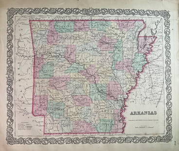
Sold20231859 Map of Arkansas by ColtonTitle: 1859 Map of Arkansas by Colton Date/Period: 1859 Materials: Steel engravedSize: 17 1/2 x 14 1/2” Arkansas. From before the civil war. By J. H. Colton & G. W. Colton. From "General Atlas".See Sold Price
Sold2023Map of 1859 Prussia and Saxony by ColtonTitle: Map of 1859 Prussia and Saxony by Colton Date/Period: 1859 Materials: Steel engraved Size: 17 1/2 x 14 1/2” Prussia and Saxony. 1859. By J. H. Colton & G. W. Colton. From "General Atlas".See Sold Price
Sold2018Antique Map of Indiana by Colton, 1859Title/Content of Map: Indiana by Colton Date Printed: 1859 Cartographer: Material/Medium: Paper Size: 14 x 17" Provenance: New York Please note that this lot has a confidential reserve. When you leaveSee Sold Price
Sold2023Map of 1859 Brazil and Guyana’s by ColtonTitle: Map of 1859 Brazil and Guyana’s by Colton Date/Period: 1859 Materials: Hand colored steering engraved Size: 17 1/2 x 14 1/2” Brazil & Guyana’s. 1859. By J. H. Colton & G. W. CSee Sold Price
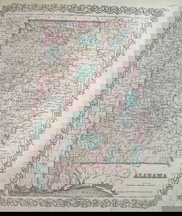
Sold20231859 Map of Alabama by ColtonTitle: 1859 Map of Alabama by Colton Date/Period: 1859 Materials: Steel engravedSize: 17 1/2 x 14 1/2” Alabama. From before the civil war. By J. H. Colton & G. W. Colton. From "General Atlas". PSee Sold Price
Sold2023Map of 1859. Patagonia, Falkland Islands by ColtonTitle: Map of 1859. Patagonia, Falkland Islands by Colton Date/Period: 1859 Materials: Hand colored steering engraved Size: 17 1/2 x 14 1/2” br>Patagonia is still not controlled by Chile or ArgeSee Sold Price
Sold2020Colton's AlabamaTitle/Content of Map: Colton's Alabama Date: 1859 Cartographer: COLTON, JOSEPH HUTCHINS Publisher: J. H. COLTON Size: 15.75Height - 12.75Width No.31 Ornamental border. 1859 year Colton atlas map, justSee Sold Price
Sold2023Map of 1859 Canada and Alaska (Russian ). By ColtonTitle: Map of 1859 Canada and Alaska (Russian ). By Colton Date/Period: 1859 Materials: Hand colored steering engraved Size: 17 1/2 x 14 1/2” What would be Canada, then British possessions withSee Sold Price
Sold20231859 Map of New Jersey by ColtonTitle: 1859 Map of New Jersey by Colton Date/Period: 1859 Materials: Steel engraved Size: 17 1/2 x 14 1/2” New Jersey. By J. H. Colton & G. W. Colton. From "General Atlas". Published in New YorkSee Sold Price
Sold20241859 Map of Netherlands & Belgium by ColtonTitle: 1859 Map of Netherlands & Belgium by Colton Date/Period: 1859 Materials: Steel engraved Size: 17 1/2 x 14 1/2” Netherlands & Belgium. 1859. By J. H. Colton & G. W. Colton. From "General ASee Sold Price
Sold2019Scarce Colton 1855 map of Texas, Johnson/BrowningScarce large map of Texas with 1855 date, but with Johnson & Browning imprint. The Johnson & Browning imprint was found in only the 1859 Colton atlas and 1860 and 1861 Johnson Family atlases. This mapSee Sold Price
Sold2017Colton: Antique Map of Cuba, 1859Title/Content of Map: Cuba by Colton Date Printed: 1859 Cartographer: H. J. Colton Material/Medium: Paper Size: 17 1/2" x 15" Hand colored engraved. Published in New York in 'Colton's General Atlas'.See Sold Price
6 days LeftTrillium Antique Prints & Rare BooksSteinlen - Original, Signed Charcoal Cat Drawing - Un chat assis regardant vers la droite [Seated$500
6 days LeftBrzostek’s Auction Service, Inc.Antique Seneca-Cayuga Wall map 1859 by Arz Dawson, Philadelphia$10
6 days LeftBrzostek’s Auction Service, Inc.Antique Seneca-Cayuga Wall map 1859 by Arz Dawson, Philadelphia$10
5 days LeftHolabird Western Americana CollectionsCalifornia Map by Colton in Frame, 1855 [180767]$150
6 days LeftConnoisseur AuctionsRare 19thc Colton Map, Argentine Republic, Chile, Uruguay, Pataguay$50
4 days LeftJasper52West Africa. Liberia Sahara Senegambia Guinea. Mountains of Kong COLTON 1869 map$20
5 days LeftHolabird Western Americana CollectionsPyramid Lake Print Pair & 1885 NM & UT Territory Map [179398]$150
4 days LeftRapid Estate Liquidators and Auction Gallery1856 Mississippi Map & Info Published By J.H. Colton & Co. No.172 William St. New York$5
5 days LeftHolabird Western Americana CollectionsMaps of San Francisco Bay 1851, 1859 (3) [180180]$150
5 days LeftHolabird Western Americana CollectionsMaps of Spain, France, & Portugal, c1800s (3) [180172]$100


![California Map by Colton in Frame, 1855 [180767] (1 of 3)](https://p1.liveauctioneers.com/2699/331495/178785753_1_x.jpg?height=282&quality=70&version=1717094933)


![Pyramid Lake Print Pair & 1885 NM & UT Territory Map [179398] (1 of 2)](https://p1.liveauctioneers.com/2699/331495/178785761_1_x.jpg?height=282&quality=70&version=1717094933)


![Maps of San Francisco Bay 1851, 1859 (3) [180180] (1 of 3)](https://p1.liveauctioneers.com/2699/331495/178785789_1_x.jpg?height=282&quality=70&version=1717094933)
![Maps of Spain, France, & Portugal, c1800s (3) [180172] (1 of 6)](https://p1.liveauctioneers.com/2699/331495/178785790_1_x.jpg?height=282&quality=70&version=1717094933)
