Sold2016Map, New York Harbor, G. Mathiot, 1886This map depicts the New York Bay and Harbor area as of 1886, printed with color and with as accurate as possible scaling and measurements of depth given the time period. The top left denotes the yearSee Sold Price
Sold20173 BIBLES & DICTIONARY OF THE HOLY BIBLE For General3 BIBLES & DICTIONARY OF THE HOLY BIBLE For General Use in The Study of the Scriptures; w/Engr., Maps, & Tables. New York: American Tract Society, Copyr't., 1886; Rev. & enlarged ed., 12mo. Orig. blacSee Sold Price
Sold2022Large lot of 1960s Nautical Chart Maps New York Harbor, Harlem River, Hudson River, Raritan RiverLarge lot of 1960s Nautical Chart Maps New York Harbor, Harlem River, Hudson River, Raritan RiverSee Sold Price
Sold2023JOHN STOBART, STATUE OF LIBERTY...NEW YORK HARBOR"John Stobart (American 1929-2003), "The Statue of Liberty in a Panorama of New York Harbor 1886", offset lithograph depicting the New York Harbor from the sailor's point of view, pencil signed and numSee Sold Price
Sold2022(NEW YORK CITY.) Sanborn Map Company. Pier Map of New York Harbor.(NEW YORK CITY.) Sanborn Map Company. Pier Map of New York Harbor. Albumen aerial photograph of lower Manhattan to front pastedown, title-page, index, double-page hand-colored lithographed key map, anSee Sold Price
Sold2023[DAKOTA]. The Mercantile Agency Reference Book (And Key) with A List of Banks and Bankers, State[DAKOTA]. The Mercantile Agency Reference Book (And Key) with A List of Banks and Bankers, State Collection Laws, Maps, Etc. New York: R. G. Dun & Co., 1908. Square 8vo. Two maps of North Dakota printSee Sold Price
Sold20151845 U.S. Coastal Survey Print NY Bay and HarborU.S. Coastal Survey Print, Map of New York Bay and Harbor and the Environs, published 1845, A.D. Bache Superintendent, overall 30-1/2 x 38-1/2""See Sold Price
Sold20211898 Cram Map of New York City -- Map of New York City…Title: 1898 Cram Map of New York City -- Map of New York City… Cartographer: G Cram Year / Place: 1898, Chicago Map Dimension (in.): 21.4 X 13.7 in. This is an excellent double-page map of ManhattanSee Sold Price
Sold20211898 Cram Map of New York City -- Map of New York andTitle: 1898 Cram Map of New York City -- Map of New York and Vicinity Cartographer: G Cram Year / Place: 1898, Chicago Map Dimension (in.): 18.8 X 12.2 in. This is an excellent double-page map of ManhSee Sold Price
Sold2023US WALL MAPS AND AERIAL VIEW OF NEW YORK CITYA lot of three antique and vintage wall maps of New York. The lot includes a 1914 map of New York bay and harbor, a D. Lambert Railing Co. color map of New York State, and an aerial view of Hudson RivSee Sold Price
Sold2018Large/scarce 1861 map of New York BayReserve Reduced! Large and scarce 1861 coastal map of New York City and its harbor. One of the earliest 19th century charts to depict New York City as we know it today. It shows Manhattan, Brooklyn anSee Sold Price
Sold2018Statue of Liberty 100th Anny Pocket WatchHunting case watch commemorating the 100th Anniversary of the installation of the Statue of Liberty in New York harbor. Marked on the dial 1886-1986. Limited Edition Commemorative Quartz. Depicts theSee Sold Price
Sold2017Colton MAP OF THE STATE OF MISSISSIPPI 1867 EngravedDetails: COLTON, George W. (1827-1901) & Charles B. (1832-1916). Colton's Map of the State of Mississippi. New York: G.W. & C.B. Colton & Co., 1867. Engraved folding pocket map, full contemporary hanSee Sold Price
Sold2022Engraved Harper's Weekly 1886 "Liberty Enlightening The World"Engraved Harper's Weekly 1886 "Liberty Enlightening The World" six-folded supplement depicting Bartholdi's colossal statue on Bedlow's Island, New York Harbor; drawn by Harry Fenn, Copyright, 1886, bySee Sold Price
Sold2017Civil War Era Map of Charleston, SC and EnvironsE & G. W. Blunt's Map of Charleston and Vicinity (New York: E & G. W. Blunt, 1862), a handy map for military purposes showing both land and sea routes in the region. Unframed in a 1950s mailing/storagSee Sold Price
Sold2021Helen Stimpson (NY,CT,b 1886) oil paintingARTIST: Helen Townsend Stimpson (New York, Connecticut, born 1886) NAME: Harbor Scene MEDIUM: oil on canvas board CONDITION: Good. No visible inpaint under UV light. Some damages to frame. SIGHT SIZE:See Sold Price
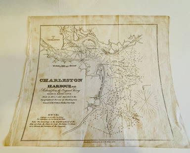
Sold2024Charleston Harbour map- Blunt 1833 mapCharleston Harbour map marked from New York published by E and G W. Blunt 1833. Engraved by William HookerSee Sold Price
Sold2023Framed Antique Agricultural Map Of NY State, 1843Marked on lower left corner reads Agricultural map of the state of New York. Lith of G & W endicott New York, Map is colored in correspondence with the color of agriculture throughout the state. FrameSee Sold Price
Sold2022Christopher G. Willett (Born 1959)Oil on board, "Statue of Liberty, New York Harbor, Sundown", SLR. Sunset landscape of the famed statue. 12"h x 12"w and 15"h x 15"w framedSee Sold Price
Sold20182 Colton Civil War Maps, Military Stations & Forts, 3Two (2) Colton Civil War maps, 3 items total. 1st item: J.H. Colton, Civil War era map of the United States showing Military Stations and Forts, prepared for The Rebellion Record, New York: G.P. PutnaSee Sold Price
Sold2016CHARLES MOTTRAM ENGRAVING, NEW YORK HARBOR AFTER J.W.CHARLES MOTTRAM ENGRAVING, NEW YORK HARBOR AFTER J.W. HILL, PUBLISHED 1855 BY F. AND G.W. SMITH. AGE TONE TO PAPER AND SPOTS OF LIGHT FOXING, SET IN MOULDED GILT WOOD FRAME, FRAMED SIZE APPROX 40" X 6See Sold Price
Sold20181984 NOAA New York Harbor Navigational ChartTitle/Content of Map: 1984 NOAA New Your Harbor Navigational Chart Issued for Statue of Liberty Centennial -- United States East Coast; New York - New Jersy; New York Harbor Date Printed: 1984, WashinSee Sold Price
Sold2023MAP: United States - East Coast. Thames River New York London Harbor Long Island to NorwichDescription: United States - East Coast Connecticut - New York. Thames River/ New York London Harbor Long Island to Norwich. Published at Washington D.C. US Department of Commerce, Environmental ScienSee Sold Price
Sold2021Antique Engraving - New York City & HarborCharles Mottram (1807-1876) engraving of New York Harbor after J.W. Hill, published 1855 by F. and G.W. Smith. Circa 1855. Marked "Proof" in lower left margin. Printed by McQueen. [Image: 33" H x 53"See Sold Price
4 days LeftKamy INCArt Deco Signed The Statue of Liberty 4th July Independent Day Bronze Sculpture$245
Jun 05PiasaHans Arp (Strasbourg, 1886 - Bale, 1966) Configuration de fragments de papiers déchirés se€20,000
Jun 06Freeman's | HindmanTHOREAU, Henry David (1817-1862). [The Season Books]. Early Spring in Massachusetts. 1881. --$400
2 days LeftJasper521886 Adams Chronological Chart of Civilizations -- A Chronological Chart of Ancient, Modern and$550
Jun 06Freeman's | HindmanPUZO, Mario (1920-1999). The Godfather. New York: G.P. Putnam's Sons, 1969.$1,500
6 days LeftCollective HudsonBalthasar Frederich Lazelt Colored Engraving Print Of Lower Manhattan Harbor Entrance Published 1775$200
Featured2 days LeftJasper521867 Beers Map of New York City Area -- Map of New York and Vicinity Accompanying "Atlas of New York$200


![[DAKOTA]. The Mercantile Agency Reference Book (And Key) with A List of Banks and Bankers, State: [DAKOTA]. The Mercantile Agency Reference Book (And Key) with A List of Banks and Bankers, State Collection Laws, Maps, Etc. New York: R. G. Dun & Co., 1908. Square 8vo. Two maps of North Dakota print](https://p1.liveauctioneers.com/197/290824/154051809_1_x.jpg?height=310&quality=70&version=1685134375)


![THOREAU, Henry David (1817-1862). [The Season Books]. Early Spring in Massachusetts. 1881. -- (1 of 1)](https://p1.liveauctioneers.com/197/329405/177652637_1_x.jpg?height=282&quality=70&version=1715364568)


