Sold2022MAP, Madagascar, SansonMadagascar. Nicolas Sanson, Isle de Madagascar ou de St. Laurens, Tiree de Sanut &c., from Geographise en Historise Werelt Beschryving, 1699 (circa). Black & White. Finely engraved, decorative map ofSee Sold Price
Sold20181683 Sanson Map of the Great Lakes and the Upper EastTitle/Content of Map: 1683 Sanson Map of the Great Lakes and the Upper East Coast -- Le Canada, ou Nouvelle France, &c. Tiree de diverses Relations des Francois, Anglois, Hollandois, &c. Date: 1683, PSee Sold Price
Sold20211683 Sanson Map Great Lakes to Newfoundland -- LeTitle: 1683 Sanson Map Great Lakes to Newfoundland -- Le Canada, ou Nouvelle France, &c. Tiree de diverses Relations des Francois, Anglois, Hollandois, &c. Cartographer: N Sanson Year / Place: 1683 c.See Sold Price
Sold20181683 Sanson Map of the Great Lakes and the Upper EastTitle/Content of Map: 1683 Sanson Map of the Great Lakes and the Upper East Coast -- Le Canada, ou Nouvelle France, &c. Tiree de diverses Relations des Francois, Anglois, Hollandois, &c. Date Printed:See Sold Price
Sold20231652 Sanson Map of the World -- L'Hydrographie ou Descriprion de L'Eau c'est a dire des Mers,Title: 1652 Sanson Map of the World -- L'Hydrographie ou Descriprion de L'Eau c'est a dire des Mers, Golfes, Lacs, Destroits, et Rivieres principales, qui font dans la Surface du Globe Terrestre . . .See Sold Price
Sold2022Alexis Hubert Jaillot and Nicolas Sanson - Map of the Grand Duchy of Moscow, Etching, 1708.Alexis Hubert Jaillot (French, 1632-1712) and Nicolas Sanson (French, 1600-1667) - Map of the White Russia or the Grand Duchy of Moscow, Etching, 1708. Title: Les Estats du Czaar de Russie Blanche ouSee Sold Price
Sold2020Nicolas Sanson Map of AsiaNicolas Sanson (1600-1667) "L'Asie divisee en ses Principales Regions, et ou se peuvent voir l'estendue, Des Empires, Monarchies, Royaumes, et Estats," Paris: Jaillot, ca. 1719. Hand colored map of AsSee Sold Price
Sold2024Sanson - Map of Canada or New France with the Great LakesThis strong map engraving is from the Dutch edition of Nicolas d'Abbeville Sanson's Cartes Generales de Toutes les Parties du Monde. The work was published in Utrecht in 1683 for the author. The atlasSee Sold Price
Sold2024Nicolas Sanson - Map of Asia / Asia divided into its Principal RegionsCopper engraving, 1600s/1700s, "Asia divided into its Principal Regions." By Mr. Sanson, Geographer Ordinary to the King. Size: 58 cm x 88 cm.See Sold Price
Sold2018RARE 17TH C. SANSON MAP OF LUXEMBOURGAlexis-Hubert Jaillot (c. 1632-1712); Nicolas Sanson (1600-1667) "Le Duche de Luxembourg Divise en Quarter Walon et Allemand....", hand colored engraving, published 1700 from earlier plates, Paris, frSee Sold Price
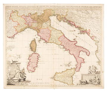
Sold2019Sanson map of Italy 1701Heading: Author: Sanson, Nicolas Title: L'Italie Divisee Suivant l'Estendue de Toutes ses Sourverainetes... Place Published: Amsterdam Publisher:Pieter Schenk Date Published: 1701 DescSee Sold Price
Sold2019MAP - Belarus. SansonBelarus. N. Sanson/Mariette, Partie de Lithuanie ou est le Palatinat de Nowogrodeck Litawiski, Subdivise en ses Chastellenies..., 1665 (dated). Hand Color. This map details much of present-day southweSee Sold Price
Sold20201598 c. de Bry Map of Madagascar -- Insula Madagascar,Title/Content of Map: 1598 c. de Bry Map of Madagascar -- Insula Madagascar, Alias S. Laurentii… / Insula de S. Laurety Cartographer: T de Bry Year/Place: 1598 c., Frankfurt Size: 5.5 X 7.6 in. ThisSee Sold Price
Sold20211652 Sanson Map of the Arabian Peninsula and the RedTitle: 1652 Sanson Map of the Arabian Peninsula and the Red Sea -- L'Arabie Petree, Deserte, et Heureuse Cartographer: N Sanson Year / Place: 1652, Paris Map Dimension (in.): 7.5 X 9.5 in. This is a rSee Sold Price
Sold2023MAP, Alps, SansonAlps - Italy, Switzerland, Austria. Nicolas Sanson, Le Tirol, souz le Nom Duquel s'Entendent le Comte de Tirol; puis les Comtes de Bregentz, Feldkirck, Montfort, Pludentz, &c. Sujets..., from Cartes GSee Sold Price
Sold2023Sanson map of ancient Asia 1650Heading: Author: Sanson, Nicolas Title: Asia Vetus Place Published: Paris Publisher: Date Published: [1650] Description: Copper-engraved map, hand-colored in outline; colored decorSee Sold Price
Sold20191700 c. Sanson Map of the Arabian Peninsula and the RedTitle/Content of Map: 1700 c. Sanson Map of the Arabian Peninsula and the Red Sea -- Arabia Petrea, Deserta et Felix Per N. Sanson Date: c. 1700 Cartographer: Based on N. Sanson Size: 7.5 X 9.5 in. ThSee Sold Price
Sold20231683 Sanson Map of South America -- Amerique MeridionaleTitle: 1683 Sanson Map of South America -- Amerique Meridionale Cartographer: N Sanson Year / Place: 1683, Paris Map Dimension (in.): 7.8 X 10/8 in. This is a superb map of South America with a charmiSee Sold Price
Sold2017Didot/Bellin: Antique Map of Madagascar, 1747Map: Carte De Toute Les Isles Connues a La Coste De Languebar Et Madagascar Publication Date: 1747 Authors: DIDOT, BELLIN, JACQUES NICOLAS, ELDER (1703-1772) Publisher: DIDOT Size: Octavo – 9.25 H xSee Sold Price
Sold2024MAP, Africa, SansonWestern Africa, Cape Verde Islands. Nicolas Sanson, D'Eilanden van Capo Verde, de Kust en't Landt der Negeren..., from Algemeene Weereld-Beschryving…, 1705 (published). Hand Color. This is an attracSee Sold Price
Sold20201690 Hoffmann Map of Madagascar -- Insula MadagascarTitle: 1690 Hoffmann Map of Madagascar -- Insula Madagascar Cartographer: J Hoffmann Year / Place: 1690 c., Nurnberg Map Dimension (in.): 3.9 X 4.7 in. This is an excellent smaller map of Madagascar aSee Sold Price
Sold20211749 Robert de Vaugondy Map of Madagascar and IndianTitle: 1749 Robert de Vaugondy Map of Madagascar and Indian Ocean Islands -- Isle de Madagascar ou de St. Laurent et Isles Circonvoisines Cartographer: D. Robert de Vaugondy Year / Place: 1749, ParisSee Sold Price
Sold2020Nicolas Sanson Map of Morea Greece 1692Nicolas Sanson (1600-1677), "La Moree et les Isles de Zante, Cafalonie, Ste Maure, Cerigo, &c." Paris: Hubert Jaillot, 1692. This hand-colored map depicts Morea, the southern part of Greece, with theSee Sold Price
Sold20191705 Sanson map of Russia w/huge marginsReserve Reduced! Beautiful specimen with modern hand coloring painstakingly applied. A strongly engraved map of European Russia showing its political divisions, major topographical features, cities anSee Sold Price
Jun 13Swann Auction Galleries(AFRICA.) Nicolas Sanson. Group of 10 small-scale engraved regional maps of the continent.$450
2 days LeftJasper52AFRICAN ISLANDS.Mauritius Madagascar Madeira Canaries St Helena 1897 old map$20(1 bid)
4 days LeftTrillium Antique Prints & Rare BooksSanson - Map of California as an Island, Mexico (Audience de Guadalajara)$160(4 bids)
4 days LeftTrillium Antique Prints & Rare BooksSanson - Map of North America with California as an Island$120(3 bids)
4 days LeftTrillium Antique Prints & Rare BooksSanson - Map of Moluccas, Celebes, & Gilolo (Halmahera)$75
BonhamsSPEED (JOHN) AND WILLEM BLAEU Pictorial title-pages to Speed's 'Theatre of the Empire of Great B...£10
Featured2 days LeftJasper52COLONIES FRANÇAISES en AFRIQUE. Africa Sénégal Madagascar. LEVASSEUR c1850 map$65
2 days LeftJasper52Colonial Southern Africa. British Portuguese German. Madagascar. TIMES 1900 map$15
2 days LeftJasper52Colonial Southern Africa. British Portuguese German. Madagascar. TIMES 1895 map$20
2 days LeftJasper52COLONIES FRANÇAISES AFRIQUE. Africa Sénégambie Madagascar. LEVASSEUR 1856 map$20
2 days LeftJasper52Carte du Canal de Mosambique…. Madagascar Bonne Esperance. BONNE 1780 map$30
Jun 15Riverfront AuctionsC. 1730 Map of North Rhine-Westphalia, Germany after N. Sanson by Covens and Mortier$5
18 hrs LeftJasper521760 Bonne Map of Reunion (Bourbon), Mauritius (I. de France) and Rodrigue(s) -- Cartes$80
2 days LeftJasper52Le Canal de Mosambique, l'Isle de Madagascar… Mozambique. Africa. BONNE 1788 map$15
2 days LeftJasper52Le Canal de Mosambique, l'Isle de Madagascar… Mozambique. Africa. BONNE 1790 map$20
2 days LeftJasper52Southern Africa Cape of Good Hope-Madagascar ADMIRALTY sea chart 1935 (1955) map$60


![Sanson map of ancient Asia 1650: Heading: Author: Sanson, Nicolas Title: Asia Vetus Place Published: Paris Publisher: Date Published: [1650] Description: Copper-engraved map, hand-colored in outline; colored decor](https://p1.liveauctioneers.com/642/310901/166355383_1_x.jpg?height=310&quality=70&version=1701367957)


