Sold2018Lower Canada or East CanadaTitle/Content of Map: Lower Canada or East Canada Date Printed: 1861 Cartographer: J.H. Colton Material/Medium: Paper Size: 14" x 17" Provenance: New York From 'Colton's General Atlas.' Published in NSee Sold Price
Sold20181850 Thomas, Cowperthwait Map of Lower Canada -- CanadaTitle/Content of Map: 1850 Thomas, Cowperthwait Map of Lower Canada -- Canada East Formerly Lower Canada Date: 1850, Philadelphia Cartographer: Thomas, Cowpertwait & Co. Size: 12.5 X 15.5 in. A handsoSee Sold Price
Sold202319thc Colton Map of Canada East, Lower Canada, New BrunswickOriginal & beautiful first edition example, 19th Century hand colored steel plate engraving atlas map by J. H. Colton on heavy paper. "Canada East or Lower Canada" with an inset of Montreal shows earlSee Sold Price
Sold2017Colton: Antique Map of East / Lower Canada, 1861Title/Content of Map: Canada east or lower Canada Date Printed: 1861 Cartographer: J. H. Colton Material/Medium: Paper Size: 17 1/2" x 13" Condition: Excellent Hand colored, steel engraved. From 'ColtSee Sold Price
Sold2017J. H. Colton Canada East (or Lower Canada) MapMap of Canada East (or Lower Canada) J. H. Colton 1857, 17.25 x 14 in Please note that this lot has a confidential reserve. When you leave a bid in advance of the auction, submit your maximum. Jasper5See Sold Price
Sold20231859. Canada east. By Colton>Title: 1859. Canada east. By Colton Date/Period: 1859 Materials: Hand colored steering engraved Size: 17 1/2 x 14 1/2” Canada east, or lower Canada. Insert of Montreal. 1859. By J. H. Colton & G. WSee Sold Price
Sold2024A framed 1844 Mitchell map of New EnglandA hand colored copy of S. Augustus Mitchell's Map of the New England or Eastern States, published in 1844, showing also parts of New York, New Brunswick and "Canada East", as Lower Canada was known frSee Sold Price
Sold2019Two Maps by A. J. Johnson, consisting of " NorthTwo Maps by A. J. Johnson, consisting of " North America," 1861, hand colored, h.- 27 in., W.- 18 1/8 in.; together with "Canada, East or Lower Canada and New Brunswick," 1863-1869, H.- 11 7/8 in., W.See Sold Price
Sold2022ROBERT CARDINAL (Massachusetts/New York/Canada, b. 1936), "East Chop"., Oil on canvas, 14” xROBERT CARDINALMassachusetts/New York/Canada, b. 1936"East Chop". Signed lower right “Cardinal”.Oil on canvas, 14” x 18”. Framed 19” x 23.25”.See Sold Price
Sold2023AQUATINT OF EAST VIEW OF MONTREALAquatint after Richard Dillon ("His Excellency most Obedient Servant"), by S. Alken, "The East View of the City of Montreal, To His Excell. Sir Robert Shore Milnes Bar. Lieutenant of Lower Canada", puSee Sold Price
Sold20211867 Map Canada / British America by Michaud"Part of British America". Depicting Canada from British Columbia east to Newfoundland. C. E. Michaud lower right corner. Very good condition; normal age toning, etc. Folds as issured. 9.75" x 35.25"See Sold Price
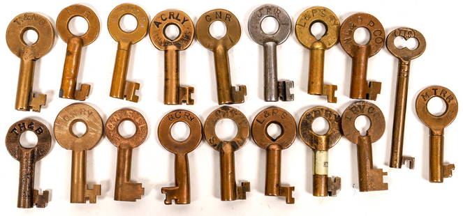
Sold2021Railroad Lock Keys (18) w/Coach Key, Canada - EastMTRR (Montreal Terminal RR); TTC (Toronto Transportation Community) (coach key); L&PS (London & Port Stanley); L&PSRY (London & Port Stanley RY); GRRY (Grand River RY); ACRLY (Algoma Central RY); CNRSee Sold Price
Sold2020NORTH AMERICA EAST Canada & USA. Canal profiles.TITLE/CONTENT OF MAP: 'NORTH AMERICA, CANADA AND THE UNITED STATES; inset canal profiles' DATE PRINTED: 1874 IMAGE SIZE: Approx 40.0 x 34.0cm, 15.75 x 13.25 inches (Large) TYPE: Antique steel engravedSee Sold Price
Sold2018Tallis/Rapkin: Antique Map East Canada & New BrunswickTitle/Content of Map: 'East Canada and New Brunswick' The map shows the southern part of Quebec and New Brunswick, in districts/counties. Vignettes: North American Indians; Quebec City Date Printed: 1See Sold Price
Sold2018NORTH AMERICA EAST. Canada USA. Canal Profiles. 1830Reserve Reduced! TITLE/CONTENT OF MAP: 'NORTH AMERICA, CANADA AND THE UNITED STATES; inset canal profiles; table of 1830 census' DATE PRINTED: 1846 IMAGE SIZE: Approx 38.5 x 33.5cm, 15.25 x 13.25 inchSee Sold Price
Sold2017Tallis/ Rapkin: Antique Map East Canada, New BrunswickTitle/Content of Map: 'East Canada and New Brunswick' The map shows the southern part of Quebec and New Brunswick, in districts/counties. Vignettes: North American Indians; Quebec Date Printed: 1851 ISee Sold Price
Sold2019EAST CANADA & NEW BRUNSWICK. Quebec. Québec city view.TITLE/CONTENT OF MAP: 'East Canada and New Brunswick' The map shows the southern part of Quebec and New Brunswick, in districts/counties. Vignettes: North American Indians; Quebec The top image on theSee Sold Price
Sold2021Tallis, John (Pub) 1852 Map East Canada & New BrunswickSteel Engraved Map with Original Outline Hand Color Published 1852-56 by John Tallis, London for "The Universal Pronouncing Dictionary" by Thomas Wright. Drawn & Engraved by John Rapkin. Centre fold aSee Sold Price
Sold2023"East Canada and New Brunswick" by John Tallis, London, c1851"East Canada and New Brunswick" by John Tallis, London, c1851.See Sold Price
Sold2017John Rapkin Map Of East Canada & New Brunswick, 1851Map: East Canada and New Brunswick Cartographer: John Rapkin Illustrator: H. Warren Publisher: John Tallis & Company Published: London and New York, 1851 Size: 10 x 13 inches Extremely clean, authentiSee Sold Price
Sold2022Times Atlas 1895 Pair of Maps. Canada - East & WestLithograph Map Published 1895, London for "The Times Atlas" Two with Centre fold as published. Up to Paper Size: 16 x 10 inch (41 x 26cm) Good ConditionSee Sold Price
Sold20191837 Return of Names of Persons Imprisoned in LowerTitle: 1837 Return of Names of Persons Imprisoned in Lower Canada Treason Provenance: [Canada] “Return of the Names of Persons Imprisoned in Lower Canada, Charged with Treason or Offences of a TreasSee Sold Price
Sold201919th Century Canadian Salt Glazed Stoneware JugInscribed “Macdonald & Charlton, St. Johns CE, 3”. St. Johns is now Saint-Jean-sur-Richelieu, Quebec. “CE” stood for “Canada East”, which was the designation for that area in the mid-19thSee Sold Price
Sold2020Maps C1840-1905 Mixed Lot of 10 Antique MapsIncl Cape of Good Hope, Monmouthshire, South America, North Asia, East Canada, West Siberia, Scotland, Greece, Russia, and Turkey. Examples by Encyclopaedia Brittannica, Stieler, Butler, and Moule. PaSee Sold Price
JG AutographsClyde East - WWII Army Air Forces Ace - Autographed Canadian Dec. of War 50 Anniv. Cover$10


![1837 Return of Names of Persons Imprisoned in Lower: Title: 1837 Return of Names of Persons Imprisoned in Lower Canada Treason Provenance: [Canada] “Return of the Names of Persons Imprisoned in Lower Canada, Charged with Treason or Offences of a Treas](https://p1.liveauctioneers.com/5584/143059/72374019_1_x.jpg?height=310&quality=70&version=1559682289)


