Sold2021Kitchin, Thomas 1785 Map of Germany & Netherlands"Germany with the Seven United Provinces" Copper Engraved Map Published 1783-85, London for "A New Geographical, Historical and Commercial Grammar..." by William Guthrie. Drawn and Engraved by ThomasSee Sold Price
Sold2021Kitchin, Thomas 1785 Antique Map of The West Indies"The West Indies Drawn and Engrav'd from the most approv'd Maps and Charts" Copper Engraved Map Published 1783-85, London for "A New Geographical, Historical and Commercial Grammar..." by William GuthSee Sold Price
Sold2021Kitchin, Thomas 1785 Antique Map of AsiaCopper Engraved Map Published 1783-85, London for "A New Geographical, Historical and Commercial Grammar..." by William Guthrie. Drawn and Engraved by Thomas Kitchin (Kitchen) and John Barber. Rare, ESee Sold Price
Sold2021Kitchin, Thomas 1785 Antique Map of The East IndiesCopper Engraved Map Published 1783-85, London for "A New Geographical, Historical and Commercial Grammar..." by William Guthrie. Drawn and Engraved by Thomas Kitchin (Kitchen) and John Barber. Rare, ESee Sold Price
Sold2021Kitchin, Thomas 1785 Antique Map of Spain & Portugal"Spain and Portugal drawn from the latest and best Authorities" Copper Engraved Map Published 1783-85, London for "A New Geographical, Historical and Commercial Grammar..." by William Guthrie. Drawn aSee Sold Price
Sold2021Kitchin, Thomas 1785 Antique Map of England and Wales"England and Wales with the Roads from the latest Surveys" Copper Engraved Map Published 1783-85, London for "A New Geographical, Historical and Commercial Grammar..." by William Guthrie. Drawn and EnSee Sold Price
Sold2021Kitchin, Thomas 1785 Antique Map of England and Wales"England and Wales with the Roads from the latest Surveys" Copper Engraved Map Published 1783-85, London for "A New Geographical, Historical and Commercial Grammar..." by William Guthrie. Drawn and EnSee Sold Price
Sold2021Barber, John 1785 Antique Map of Russia"Russia or Muscovy in Europe" Copper Engraved Map Published 1783-85, London for "A New Geographical, Historical and Commercial Grammar..." by William Guthrie. Drawn and Engraved by Thomas Kitchin (KitSee Sold Price
Sold2021Barber, John 1785 Antique Map of Turkey & Hungary"Turky in Europe &c. Hungary" Copper Engraved Map Published 1783-85, London for "A New Geographical, Historical and Commercial Grammar..." by William Guthrie. Drawn and Engraved by Thomas Kitchin (KitSee Sold Price
Sold2021Guthrie, William 1806 Map. Holland Netherlands"The Severn United Provinces" Copper Engraved Map Published 1806, London for "A New Geographical, Historical and Commercial Grammar..." by William Guthrie. The maps are by John Senex, Thomas Kitchin aSee Sold Price
Sold2021Guthrie, William 1790 Antique Map. NetherlandsCopper Engraved Map Published 1790, London for "A New Geographical, Historical and Commercial Grammar..." by William Guthrie. The maps are by John Senex, Thomas Kitchin and others. Folds as issued. EaSee Sold Price
Sold2021Guthrie, William 1806 Map. GermanyCopper Engraved Map Published 1806, London for "A New Geographical, Historical and Commercial Grammar..." by William Guthrie. The maps are by John Senex, Thomas Kitchin and others. Folds as issued. PaSee Sold Price
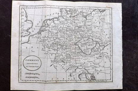
Sold2021Guthrie, William 1798 Map. GermanyCopper Engraved Map Published 1798, London for "A New Geographical, Historical and Commercial Grammar..." by William Guthrie. The maps are by John Senex, Thomas Kitchin and others. Folds as issued. PaSee Sold Price
Sold2021Guthrie, William 1798 Map. GermanyCopper Engraved Map Published 1798, London for "A New Geographical, Historical and Commercial Grammar..." by William Guthrie. The maps are by John Senex, Thomas Kitchin and others. Folds as issued. PaSee Sold Price
Sold2021Guthrie, William 1798 Pair of Maps. Netherlands HollandCopper Engraved Map Published 1798, London for "A New Geographical, Historical and Commercial Grammar..." by William Guthrie. The maps are by John Senex, Thomas Kitchin and others. Folds as issued. PaSee Sold Price
Sold2022Guthrie & Kitchin 1782 Map. GermanyCopper Engraved Map Published 1782, London for "A New Geographical, Historical and Commercial Grammar..." by William Guthrie. The maps are by John Senex, Thomas Kitchin and others. Folds as issued. PaSee Sold Price
Sold2021Guthrie, William 1806 Map. NetherlandsCopper Engraved Map Published 1806, London for "A New Geographical, Historical and Commercial Grammar..." by William Guthrie. The maps are by John Senex, Thomas Kitchin and others. Folds as issued. PaSee Sold Price
Sold2021Kitchin, Thomas 1785 Astronomy Print. Armillary SphereCopper Engraved Plate Published 1783-85, London for "A New Geographical, Historical and Commercial Grammar..." by William Guthrie. Drawn and Engraved by Thomas Kitchin (Kitchen) and John Barber. Rare.See Sold Price
Sold20241730 antique MAP of GERMANY Netherlands Belgium Luxemburg 18th CENTURYNetherlands, Belgium, Luxemburg Tabula generalis totius Belgii qua Provinciae XVII Infer. Germania olim sub S.R.I. Vircula Burgundiae by Homann, Johann Baptist, 1663-1724 Nuremberg, 1730 Size 20.5 bySee Sold Price
Sold2019Kitchin, Thomas 1758 Map of England and Wales"A New Map of England and Wales" Copper Engraved Map Published 1758, London for "A Complete History of England…" by Thomas Smollett. Map by Thomas Kitchin (Kitchen) Folds as issued. Paper Size: 20 xSee Sold Price
Sold2023Baedeker, Karl 1900 Lot of 63 Maps. Rhine - Germany, Netherlands, AustriaLithograph Maps Published 1900, Leipzig for "The Rhine from Rotterdam to Constance" by Karl Baedeker. Folds as issued. Paper Size: Up to 22.5 x 6 inch (57 x 15cm) Good ConditionSee Sold Price
Sold2020KITCHIN, THOMAS. A New Map of the British Empire inKITCHIN, THOMAS. A New Map of the British Empire in Nth. America. Hand-colored engraved folding map of colonial North America from George Millar's New and Universal System of Geography. 13½x15See Sold Price
Sold2019Thomas Kitchin Map [Europe]Thomas Kitchin (cartographer) color map of 'Europe Drawn from the best Authorities by T. Kitchin'. Published London, mid-18th century. In G/G+-VG condition, with foxing and spotting in margins. Two foSee Sold Price
Sold2016Electorate of Brandenburg, Germany. Thomas Kitchin.From A New Universal Atlas Maker: Kitchin, Thomas. Origin: London, Laurie & Whittle, 1798. Medium: Original engraving hand-colored at publication. Sheet size: 21 1/4 x 15 3/4 in. No Reserve: This lotSee Sold Price
4 days LeftJasper521552 Munster Map of Netherlands and Western Germany -- Brabantia III Rheniet X Nova Tabula$240
4 days LeftJasper521636 Jansson Map of the Course of the Rhine River -- Rhenus Fluviorum Europae Celeberrimus$320
Jun 15Riverfront Auctions'1785 Bocage Map of the City of Athens in Ancient Greece' Par M. Barbié du Bocage$5(1 bid)
4 days LeftJasper521552 Munster Map of Southern Germany and Switzerland -- Suevia et Bavaria XII Nova Tabula$160
Jun 07Freeman's | HindmanHUGHES, Griffith. The Natural History of Barbados. 1750. FIRST EDITION.$1,000
Jun 08Early American History AuctionsTHOMAS CRANSTON Signed Rhode Island, Seven Years War Pay Order from the Committee of War$650
6 days LeftNY Elizabeth ILLUSTRATED ANCIENT ROMAN CHURCH HISTORY FRANCE ITALY GERMANY SWITZERLAND 1700$50
14 hrs LeftTrillium Antique Prints & Rare BooksDe Jode, Rare, pub. 1593 - Electors of the Holy Roman Empire (Ordines Sacri Romani Imp: Ab Ottone$100(1 bid)
6 days LeftLeland LittleEnglish School (19th Century), Five Racehorse and Jockey Portraits Published by Sporting Gallery$50
15 hrs LeftAuction WallstreetVintage Seth Thomas Woodbury Westinster Chime Mantle Clock. Made in Germany$40
Jun 02Tremont AuctionsJoseph Jansen. Germany. Large Alpine landscape painting depicting Lauterbrunnen and the Staubbach$1,500


![Thomas Kitchin Map [Europe]: Thomas Kitchin (cartographer) color map of 'Europe Drawn from the best Authorities by T. Kitchin'. Published London, mid-18th century. In G/G+-VG condition, with foxing and spotting in margins. Two fo](https://p1.liveauctioneers.com/5755/147592/74586078_1_x.jpg?height=310&quality=70&version=1565302309)


