Sold2023Johnson & Exley 1812 Antique Map. EuropeCopper Engraved Map Published 1812, London for "The Imperial Encyclopaedia; Or, Dictionary of the Sciences and Arts" by William Moore Johnson & Thomas Exley. Paper Size: 10.5 x 8.5 inch (27 x 22cm) WaSee Sold Price
Sold2023Johnson & Exley 1812 Antique Map. North AmericaCopper Engraved Map Published 1812, London for "The Imperial Encyclopaedia; Or, Dictionary of the Sciences and Arts" by William Moore Johnson & Thomas Exley. Paper Size: 10.5 x 8.5 inch (27 x 22cm) WaSee Sold Price
Sold2024Johnson & Exley 1812 Antique Map. AfricaCopper Engraved Map Published 1812, London for "The Imperial Encyclopaedia; Or, Dictionary of the Sciences and Arts" by William Moore Johnson & Thomas Exley. Paper Size: 10.5 x 8.5 inch (27 x 22cm) WaSee Sold Price
Sold2023Johnson & Exley 1812 Antique Map. England & WalesCopper Engraved Map Published 1812, London for "The Imperial Encyclopaedia; Or, Dictionary of the Sciences and Arts" by William Moore Johnson & Thomas Exley. Paper Size: 10.5 x 8.5 inch (27 x 22cm) WaSee Sold Price
Sold2023Johnson & Exley 1812 Antique Map. AsiaCopper Engraved Map Published 1812, London for "The Imperial Encyclopaedia; Or, Dictionary of the Sciences and Arts" by William Moore Johnson & Thomas Exley. Paper Size: 10.5 x 8.5 inch (27 x 22cm)See Sold Price
Sold2023Johnson & Exley 1812 Antique Map. GermanyCopper Engraved Map Published 1812, London for "The Imperial Encyclopaedia; Or, Dictionary of the Sciences and Arts" by William Moore Johnson & Thomas Exley. Paper Size: 10.5 x 8.5 inch (27 x 22cm) WaSee Sold Price
Sold2023Johnson & Exley 1812 Antique Folio Map. World HemispheresCopper Engraved Map Published 1812, London for "The Imperial Encyclopaedia; Or, Dictionary of the Sciences and Arts" by William Moore Johnson & Thomas Exley. Paper Size: 17 x 10.5 inch (43 x 27cm) WatSee Sold Price
Sold2017Johnson: Four Antique Historical Maps of Europe, 1881Map: Europe Under the Romans (2nd Century). | Europe Under the Carlovingians (9th Century). | Europe Under Napoleon I. (1810-1812). | Map of The Languages of Europe. Publication Date: 1881 Authors: A.See Sold Price
Sold2023Johnson & Exley 1812 Antique Print. Boa Constrictor, SnakesCopper Plate Pulished 1812, London for "The Imperial Encyclopaedia; Or, Dictionary of the Sciences and Arts" by William Moore Johnson & Thomas Exley. Paper Size: 10.5 x 8.5 inch (27 x 22cm) Good CondiSee Sold Price
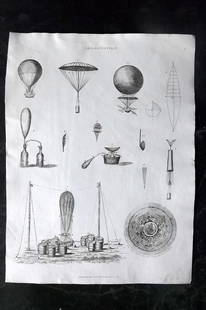
Sold2023Johnson & Exley 1812 Antique Print. Aerostation BalloonCopper Plate Pulished 1812, London for "The Imperial Encyclopaedia; Or, Dictionary of the Sciences and Arts" by William Moore Johnson & Thomas Exley. Paper Size: 10.5 x 8.5 inch (27 x 22cm) Good CondiSee Sold Price
Sold2017Johnson: Antique Map of Europe, 1864Map: 1864 Johnson Map of Europe -- Johnson's Europe Cartographer: A Johnson Year / Place: 1864, New York Dimensions: 17 X 23 in. Condition: Excellent - very good. Hand colored. Issued centerfold. SligSee Sold Price
Sold2023Johnson & Exley 1812 Pair of Antique Fish PrintsCopper Plate Pulished 1812, London for "The Imperial Encyclopaedia; Or, Dictionary of the Sciences and Arts" by William Moore Johnson & Thomas Exley. Paper Size: 10.5 x 8.5 inch (27 x 22cm) Good CondiSee Sold Price
Sold2023Johnson & Exley 1812 Lot of 3 Antique Ship PrintsCopper Plate Pulished 1812, London for "The Imperial Encyclopaedia; Or, Dictionary of the Sciences and Arts" by William Moore Johnson & Thomas Exley. Paper Size: 10.5 x 8.5 inch (27 x 22cm) A few smalSee Sold Price
Sold2023Johnson & Exley 1812 Lot of 4 Antique Mammal PrintsCopper Plate Pulished 1812, London for "The Imperial Encyclopaedia; Or, Dictionary of the Sciences and Arts" by William Moore Johnson & Thomas Exley. Paper Size: 10.5 x 8.5 inch (27 x 22cm) One with cSee Sold Price
Sold2017Malte-Brun: Antique Double Map of Europe in 1500 & 1789Title/Content of Map: 1812 Malte-Brun Map Double Map of Europe in 1500s and 1789 -- Europe sons Charles-Quint [together with] Europe en 1789 Date Printed: 1812, Paris Cartographer: M Malte-Brun Size:See Sold Price
Sold2024Europe by Arrowsmith & Lewis 1812 old antique vintage map plan chartTITLE/CONTENT OF MAP: 'Europe' DATE PRINTED: 1812 IMAGE SIZE: Approx 25.0 x 20.0cm, 9.75 x 8 inches (Medium) TYPE: Antique steel engraved map CONDITION: Good; suitable for framing. Please check the scSee Sold Price
Sold2020AN ANTIQUE MAP, "Europe (Evrop)," JOHN SPEED,AN ANTIQUE MAP, "Europe (Evrop)," JOHN SPEED, CARTOGRAPHER, 1626-1676, hand-colored engraving on paper, Abraham Goos (1589-1643), engraver, published for merchants Thomas Basset and Richard Chiswell iSee Sold Price
Sold2017Johnson: Antique Map of Florida, 1864Map: 1864 Johnson Map of Florida -- Johnson's Florida Cartographer: A Johnson Year / Place: 1864, New York City Map Dimensions: 12 x 15.3 in. Condition: Very Good. Vivid colors. Slight age toning throSee Sold Price
Sold2017Johnson: Antique Map of New York City, 1866Title/Content of Map: 1866 Johnson Map of New York City -- Johnson's New York and Brooklyn Date Printed: 1866, New York Cartographer: A Johnson Size: 22.8 x 16.3 in Condition: Very good. Age toning noSee Sold Price
Sold2017Johnson: Antique Map Nebraska Dakota Idaho MontanaJohnson’s Nebraska, Dakota, Idaho and Montana, c1865. One of the earliest appearances of Wyoming on a map -- so early, it has not been added to the map title. Pre-dates Yellowstone. Wyoming is in aSee Sold Price
Sold2017Johnson: Antique Map of Palestine, 18611861 Johnson’s Palestine. Beautiful layout with engraved view of City of Damascus and inset map of Jerusalem. Excellent impression and great original hand coloring. From the final Johnson & BrowningSee Sold Price
Sold2021de Fer, Nicolas 1717 Antique Map. Europe"L'Europe Suivant les Nouvelles Observations" Copper Engraved Map Published 1717, Paris for "Introduction a la Geographie" by Nicolas de Fer. Folds as issued. Paper Size: 14 x 10 inch (36 x 25cm) GoodSee Sold Price
Sold2017Johnson: Antique Map of Australia, 1863Title/Content of Map: 1863 Johnson's Map of Australia -- Johnson's Australia Date Printed: 1863, New York Cartographer: A Johnson Size: 13.1 x 15.2 in. An eloquent map showing six territories of AustrSee Sold Price
Sold2018Johnson: Antique Map of North and South Carolina, 1864Title/Content of Map: 1864 Johnson Map of North and South Carolina -- Johnson's North and South Carolina Date Printed: 1864, New York Cartographer: Johnson & Ward Size: 17.3 x 24 in. An excellent, larSee Sold Price
Featured1 day LeftJasper52Johnson's Europe. Navigators' routes. Continental Shelf 1861 old antique map$65
1 day LeftJasper52Johnson's Roman Empire. Imperium Romanorum. Graecia Italia Greece Italy 1861 map$160
May 30NY Elizabeth ANTIQUE MAP-ILLUSTRATED FLORAL ILLUSTRATION 1761 NEW DICTIONARY OF TRADE AND COMMERCE R. ROTH$50
Featured1 day LeftJasper52Europe after the Congress of Vienna. 4 sheets. 128x106cm. THOMSON 1817 old map$550
Featured1 day LeftJasper52Pictorial map of the Caucasus. Russia Georgia Azerbaijan Armenia INTOURIST c1932$850


![Malte-Brun: Antique Double Map of Europe in 1500 & 1789: Title/Content of Map: 1812 Malte-Brun Map Double Map of Europe in 1500s and 1789 -- Europe sons Charles-Quint [together with] Europe en 1789 Date Printed: 1812, Paris Cartographer: M Malte-Brun Size:](https://p1.liveauctioneers.com/5584/112159/57581953_1_x.jpg?height=310&quality=70&version=1510710796)


