Sold2018India 1882 Pair of Maps by BlackieLithograph Maps Published 1882 by Blackie & Son, London for "The Comprehensive Atlas & Geography of the World" by W. G. Blackie. Paper Size: 22 x 15 inch (56 x 38cm) Small margin tear to one. Good conSee Sold Price
Sold2019Blackie & Weller 1882 Pair of Maps of IndiaIndia and India South Part. Lithograph Maps Published 1882 by Blackie & Son, London for "The Comprehensive Atlas & Geography of the World" by W. G. Blackie. Maps by Edward Weller. Centre fold as issueSee Sold Price
Sold2019Blackie & Weller 1882 Pair Maps of USA & North America"The United States of North America, Pacific States" and "North America" Lithograph Maps Published 1882 by Blackie & Son, London for "The Comprehensive Atlas & Geography of the World" by W. G. BlackieSee Sold Price
Sold2019Blackie & Weller 1882 Pair of Maps of China"China" and "The Chinese Empire and Japan" Lithograph Maps Published 1882 by Blackie & Son, London for "The Comprehensive Atlas & Geography of the World" by W. G. Blackie. Maps by Edward Weller. CentrSee Sold Price
Sold2024Blackie (Pub) 1882 Folio Map. West India Islands & Central AmericaLithograph Map Published 1882 by Blackie & Son, London for "The Comprehensive Atlas & Geography of the World" by W. G. Blackie. Centre fold as published. Paper Size: 22 x 15 inch (56 x 38cm) Good condSee Sold Price
Sold2019Japan C1880 Pair of Maps by Nolan & Blackie"The Islands of Japan with Corea..." Steel Engraved Map Published C1880, London for "The Illustrated History of the British Empire in India and the East" by Edward H. Nolan. Centre fold as published.See Sold Price
Sold2019West Indies/Caribbean 1874-82 Pair of MapsLithograph Maps Published 1882 by Blackie & Son, London for "The Comprehensive Atlas & Geography of the World" by W. G. Blackie. Maps by Edward Weller. Plus one other Published 1874, London for "The PSee Sold Price
Sold2023NILE VALLEY. Upper & Lower. Egypt Sinai Nubia Sudan Abyssinia. BLACKIE 1882 mapTITLE/CONTENT OF MAP: 'The Nile-Valley from the Sea to the second cataract including Egypt and part of Nubia. Also the Peninsula of Mt. Sinai; The Nile-Valley from the second cataract upwards, includiSee Sold Price
Sold2024NILE VALLEY. Upper & Lower. Egypt Sinai Nubia Sudan Abyssinia. BLACKIE 1882 mapTITLE/CONTENT OF MAP: 'The Nile-Valley from the Sea to the second cataract including Egypt and part of Nubia. Also the Peninsula of Mt. Sinai; The Nile-Valley from the second cataract upwards, includiSee Sold Price
Sold2024NILE VALLEY. Upper & Lower. Egypt Sinai Nubia Sudan Abyssinia. BLACKIE 1882 mapTITLE/CONTENT OF MAP: 'The Nile-Valley from the Sea to the second cataract including Egypt and part of Nubia. Also the Peninsula of Mt. Sinai; The Nile-Valley from the second cataract upwards, includiSee Sold Price
Sold2024Duval - Pair: Map of India & Map of MaldivesThis fascinating map is from Pierre Duval. It was part of a composite or collector's atlas of his maps. It was done in Paris circa 1670s. The composite atlas originally included maps from the followinSee Sold Price
Sold2019Blackie & Weller 1882 Map of The World HemispheresLithograph Map Published 1882 by Blackie & Son, London for "The Comprehensive Atlas & Geography of the World" by W. G. Blackie. Maps by Edward Weller. Centre fold as issued. Paper Size: 21.5 x 15 inchSee Sold Price
Sold2019Blackie & Weller 1882 Map of the North Pole"North Circumpolar Regions" Lithograph Map Published 1882 by Blackie & Son, London for "The Comprehensive Atlas & Geography of the World" by W. G. Blackie. Maps by Edward Weller. Paper Size: 15 x 11 iSee Sold Price
Sold2019Blackie & Weller 1882 Map of MexicoLithograph Map Published 1882 by Blackie & Son, London for "The Comprehensive Atlas & Geography of the World" by W. G. Blackie. Maps by Edward Weller. Centre fold as issued. Paper Size: 21.5 x 15 inchSee Sold Price
Sold2019Blackie & Weller 1882 Map of the East Indies, Indonesia"The Indian Archipelago" Lithograph Map Published 1882 by Blackie & Son, London for "The Comprehensive Atlas & Geography of the World" by W. G. Blackie. Maps by Edward Weller. Centre fold as issued. PSee Sold Price
Sold20211882 Map of South AfricaAuthor: Blackie Title: 1882 Map of South Africa Medium: Ink on Paper Dimensions: 21"X15" Map of South Africa dated 1882. Part of the Comprehensive Atlas & Geography of the World. Engraved by Edwin WelSee Sold Price
Sold20211882 Map of TurkeyAuthor: Blackie Title: 1882 Map of Turkey Medium: Ink on Paper Dimensions: 21"X15" Map of Turkey in Asia dated 1882. Part of the Comprehensive Atlas & Geography of the World. Engraved by Edwin WellerSee Sold Price
Sold20211882 Map of FinlandAuthor: Blackie Title: 1882 Map of Finland Medium: Ink on Paper Dimensions: 15"X10.5" Map of Finland dated 1882. Part of the Comprehensive Atlas & Geography of the World. Engraved by James William LowSee Sold Price
Sold2017Blackie: Map of East Asia, 1882Title/Content of Map: 'The Chinese empire and Japan'. EAST ASIA: Chinese Empire & Japan. Scale in Chinese Li. BLACKIE, 1882 old map This map is folding hence the centrefold line may show on the imageSee Sold Price
Sold2024Blackie (Pub) 1882 Large Map. World on Mercators ProjectionLithograph Maps Published 1882 by Blackie & Son, London for "The Comprehensive Atlas & Geography of the World" by W. G. Blackie. Paper Size: 22.5 x 15.5 inch (57 x 39cm) Good conditionSee Sold Price
Sold2024Blackie (Pub) 1882 Large Map. World HemispheresLithograph Maps Published 1882 by Blackie & Son, London for "The Comprehensive Atlas & Geography of the World" by W. G. Blackie. Paper Size: 22.5 x 15.5 inch (57 x 39cm) Good conditionSee Sold Price
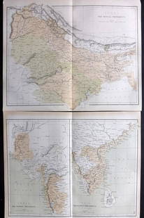
Sold2021Nolan, Edward C1880 Pair of Maps of India"India. The Bombay Presidency/India. The Madras Presidency" and "India The Bengal Presidency" Steel Engraved Map Published C1880, London for "The Illustrated History of the British Empire in India andSee Sold Price
Sold2022Blackie & Weller 1882 Large Map of North AmericaLithograph Map Published 1882 by Blackie & Son, London for "The Comprehensive Atlas & Geography of the World" by W. G. Blackie. Maps by Edward Weller. Centre fold as issued. Paper Size: 21.5 x 15 inchSee Sold Price
Sold2022Blackie & Weller 1882 Large Map of MexicoLithograph Map Published 1882 by Blackie & Son, London for "The Comprehensive Atlas & Geography of the World" by W. G. Blackie. Maps by Edward Weller. Centre fold as issued. Paper Size: 21.5 x 15 inchSee Sold Price
5 days LeftJasper52S AMERICA. Patagonia La Plata.Bolivia with Litoral.New Granada/Colombia 1882 map$8
Jun 02Schilb Antiquarian Rare Books1897 History of British Empire England Scotland Canada James II MAPS India 6v$5(3 bids)
19 hrs LeftYorkville Auction Appraisalspair Indian Mughal Silver gold Inlaid Bidri Spitt pair Indian Mughal Silver and gold Inlaid Bidri$100
Jun 15Riverfront AuctionsMaps of the Miami Canal and Spring Grove, Avondale & Cincinnati Railway Deed$5
398 Lots AwayHermann Historica GmbHA pair of Indian gold bracelets with enamel and diamonds, circa 1900See Sold Price