Sold2023GEORGE CRAM'S AMERICAN ATLAS OF THE UNITED STATESGEORGE CRAM'S AMERICAN ATLAS OF THE UNITED STATESGeorge F. Cram, proprietor of the Western Map Depot, Chicago, IL, 1878. Color maps within.22.1 x 17.6 in. (56.1 x 44.7 cm.)See Sold Price
Sold2023Il Regno della China detto presentemente Catay e Mangin… ROSSI/CANTELLI 1682 mapTitle: Il Regno della China detto presentemente Catay e Mangin… ROSSI/CANTELLI 1682 map Description: Il Regno della China detto presentemente Catay e Mangin, diviso sopra le carte piu esatte nelSee Sold Price
Sold2022[MANUSCRIPT MAP-FLORIDA & MISSISSIPPI RIVER] Map Showing Raiford's Proposed Artificial River and[MANUSCRIPT MAP-FLORIDA & MISSISSIPPI RIVER] Map Showing Raiford's Proposed Artificial River and Plan to Continue the Western and Southern Inland System of Navigation to Harbors in the Atlantic. [FernSee Sold Price
Sold2022Dudley Sea Chart of Western FranceDUDLEY, Sir Robert (1574-1649). [France] Carta particolare della costa di Guasconnia in Francia che comincia con il Fiuime di Burdeaux e Finisce con l'Isola di Heys. Engraved map. Florence, 1646. 20 7See Sold Price
Sold2022Antique Japanese MapAntique Japanese Map, Marked Ishi-Kawa-Ryugi, Genroku Yonen-Ban-Nippon-zu, Tokyo, Sagamiya, 1691, Maps Of Japan. Folded Approximately 10.375L x 7.0625W in. Unfolded Approximately 66L x 40.25W in.See Sold Price
Sold2021MAP, Western Hemisphere, BlaeuBlaeu's Stunning Carte-a-Figures Map of the Americas in Full Contemporary Color. Western Hemisphere - America. Willem Blaeu, Americae Nova Tabula, 1642 (circa). Hand Color. This stunning carte-a-figurSee Sold Price
Sold2021Late 16th C. North Italian Steel Field Armor SuitWestern/Southern Europe, northern Italy, perhaps Brescia or Milan, and Germany, ca. 1580s CE. A suit of steel-plate armor used for field duties. The close helmet features a roped vertical crest, a visSee Sold Price
Sold20211721 Map of America With California as an IslandHistoric Maps 1721 Hand-Colored "A New Map of America from the Latest Observations" with "California" Shown as an Island 1721 Hand-Colored Engraved Western Hemisphere Map titled, "A New Map of AmericaSee Sold Price
Sold2022Ortelius 16th Cent. ''Americae Siv Novi Orbis' MapAbraham Ortelius 16th Cent. ''Americae Siv Novi Orbis Nova Descriptio'' Map Engraving. Hand tinted Western Hemisphere map of America circa 1570-73, printed in Antwerp. Gallery framed with glass on botSee Sold Price
Sold2020Mitchell Map of Western U.S.*** START PRICE IS THE RESERVE *** [America] MITCHELL, Samuel Augustus (1792-1868). A New Map of Texas, Oregon and California with the Regions Adjoining. Engraving with original hand color, with origiSee Sold Price
Sold2018South East Asia.- Ortelius (Abraham) Indiae OrientalisSouth East Asia.- Ortelius (Abraham) Indiae Orientalis Insularumque Adiacientium Typus, map of southern Asia from India across to Java and New Guinea, and including China and Japan to the north, withSee Sold Price
Sold2022Colom's Map of the Western Indian Ocean, c. 1658COLOM, Arnold (1624-1668). Oost Indien van Cabo de Bona Esperanca tot Ceilon. Engraved map with original hand color in outline. Amsterdam, c. 1658. 22 1/4" x 25 1/2" sheet. Colom's Zee Atlas is amongSee Sold Price
Sold2022ORTELIUS, ABRAHAM. Americae Sive Novi Orbis, Nova Descriptio.ORTELIUS, ABRAHAM. Americae Sive Novi Orbis, Nova Descriptio. Double-page engraved map of the Western Hemisphere. 17½x22¼ inches sheet size, wide margins, Spanish text on verso; uncolored; cSee Sold Price
Sold2024Abraham Ortelius (Belgian 1527 - 1598)Abraham Ortelius (Belgian 1527 - 1598) "Americae Sive Novi Orbis, Nova Descriptio", circa 1602 Copper engraved hand colored map of the Western Hemisphere 15" x 20" Condition: aging, yellowing to paperSee Sold Price
Sold2021Rare set H.C. Tunison Wall MapsHeading: Author: Tunison, Henry Cuthbert Title: Tunison’s Twentieth Century Series of School Maps Place Published: Jacksonville, IL Publisher:H.C. Tunison, Publisher Date Published: c.1905See Sold Price
Sold2022(NETHERLANDS.) Nicolaas and Jacob Cruquius. T Hooge Heemraedschap van Delflant.(NETHERLANDS.) Nicolaas and Jacob Cruquius. T Hooge Heemraedschap van Delflant. Atlas-format wall map of the vicinity of Delft and The Hague in western Netherlands. Double-page engraved key map in stuSee Sold Price
Sold2018Very Rare Rockingham-Glazed Anna Pottery Pig BottleVery Rare Rockingham-Glazed Anna Pottery Pig Bottle with Incised Railroad Map, Wallace and Cornwall Kirkpatrick, Anna, IL, circa 1880, molded in the form of a reclining pig with incised snout and hoovSee Sold Price
Sold2024Coronelli's elegant two-sheet hemispheric world map[MAP - WORLD] CORONELLI, VINCENZO MARIA. Planisfero Del Mondo Vecchio; [and] Planisfero Del Mondo Nuovo. [Venice: circa 1691]. Two hand-colored engraved hemispheric world maps printed on separate sheeSee Sold Price
Sold2022Railroad Lock Keys (18), multiple Iowa RR LinesID Marks: N&NRR (Newton & Northwestern RR); CR&ICRY (Cedar Rapids &Iowa City RY); DM&CI (Des Moines & Central Iowa); FDDM&S (Fort Dodge Des Moines & Southern); DEMCRYCO (Des Moines City RY); DMURR (DeSee Sold Price
2021GREAT NORTHERN’S 2 GREAT TRAINS SYSTEM MAP.Huge dramatic reverse glass advertising Great Northern's two great trains, Empire Builder and Western Star. In script just below Great Northern logo it states "Steamliners twice a day, each way, betweSee Sold Price
Sold2020Good Early Southern HighboyGood early highboy. Primary wood looks like walnut. Yellow pine secondary wood. Probably South western Pennsylvania. H 72", W lower case: 40"; W upper case 38-1/2, overall D 22-1/4". Provenance. SuzieSee Sold Price
Sold2022Antique Powel and Kingmans New Mexico MapSouth Western New Mexico, 1883. 34 x 46 inchesSee Sold Price
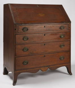
Sold2020Southern Federal Eagle Inlaid DeskSouthern Federal Eagle inlaid & carved slant lid desk, wild cherrywood with hard pine secondary , probably western Maryland, ca. 1795-1802. The dovetailed case presents a molded and inlaid hinged slanSee Sold Price
1 day LeftJasper52WESTERN ASIA 970-1070 AD. under the Mohammadan Muslim Dynasties 1902 old map$15(1 bid)
1 day LeftJasper52WESTERN ASIA 1190. Saladin's Syrian conquests. Atabegs Kingdom 1160 1902 map$8(1 bid)
1 day LeftJasper52WESTERN ASIA IN 786 AD. under the Abbāsid Abbasid Caliphs 1902 old antique map$20
Featured1 day LeftJasper52Asie. Tartarie #42 South Kazakhstan. North Kyrgyzstan. VANDERMAELEN 1827 map$60
Jun 23Schilb Antiquarian Rare Books1848 Emory Military Reconnaissance 1ed California MAP Indians Texas New Mexico$2(2 bids)
3 days LeftMeander Auctions by Andrew Richmond and Hollie DavisOHIO VALLEY SHERATON CHEST OF DRAWERS$200(2 bids)
Featured6 hrs LeftJasper52Johnson's New Military Map of the United States Showing the Forts, Military Posts &C. With Enlarged$65
Jun 30JM Hobby Supply and Railroad Artifact AuctionsTwo Micro-Trains HOn3 Narrow Gauge Cars-Colorado and Southern/Denver Boulder and Western$20


![[MANUSCRIPT MAP-FLORIDA & MISSISSIPPI RIVER] Map Showing Raiford's Proposed Artificial River and: [MANUSCRIPT MAP-FLORIDA & MISSISSIPPI RIVER] Map Showing Raiford's Proposed Artificial River and Plan to Continue the Western and Southern Inland System of Navigation to Harbors in the Atlantic. [Fern](https://p1.liveauctioneers.com/292/250642/130213644_1_x.jpg?height=310&quality=70&version=1654271664)
![Dudley Sea Chart of Western France: DUDLEY, Sir Robert (1574-1649). [France] Carta particolare della costa di Guasconnia in Francia che comincia con il Fiuime di Burdeaux e Finisce con l'Isola di Heys. Engraved map. Florence, 1646. 20 7](https://p1.liveauctioneers.com/1968/250616/130196506_1_x.jpg?height=310&quality=70&version=1654190895)


![Mitchell Map of Western U.S.: *** START PRICE IS THE RESERVE *** [America] MITCHELL, Samuel Augustus (1792-1868). A New Map of Texas, Oregon and California with the Regions Adjoining. Engraving with original hand color, with origi](https://p1.liveauctioneers.com/1968/163248/82424595_1_x.jpg?height=310&quality=70&version=1583340284)


![Coronelli's elegant two-sheet hemispheric world map: [MAP - WORLD] CORONELLI, VINCENZO MARIA. Planisfero Del Mondo Vecchio; [and] Planisfero Del Mondo Nuovo. [Venice: circa 1691]. Two hand-colored engraved hemispheric world maps printed on separate shee](https://p1.liveauctioneers.com/292/326828/175962847_1_x.jpg?height=310&quality=70&version=1713473479)


![[MAPS]. A group of 3 engraved maps, most with hand-coloring. (1 of 4)](https://p1.liveauctioneers.com/197/328642/177014805_1_x.jpg?height=282&quality=70&version=1714760103)


