Sold2018(I) Map of Louisiana Representing the Several LandTitle: (I) Map of Louisiana Representing the Several Land Districts... Publication Date: 1851-10-25 Cartographer: BOYD, R.W. (SURVEYOR GENERAL, LA) Publisher: BOYD, R.W. Size: 15 X 16.5 Prepared to acSee Sold Price
Sold2018Antique Surveyor's Map of Louisiana, 1860Title/Content of Map: 1860 Surveyor's Map of Louisiana -- No. 8 (H) Map of Louisiana Representing the Several Land Districts Date Printed: 1860 New York Cartographer: W. McCulloh Size: 15.5 x 16 in. TSee Sold Price
Sold20181855 Land Office Survey Map of Louisiana -- (H) Map ofReserve Reduced! Title/Content of Map: 1855 Land Office Survey Map of Louisiana -- (H) Map of Louisiana Representing the Several Land Districts Prepared to Accompany the Surveyor Generals Report Date:See Sold Price
Sold2023ANTIQUE c.1850 MAP of LOUISIANA w LAND DISTRICT s by W R BOYD SURVEYOR GEN'L, LAANTIQUE c.1850 MAP of LOUISIANA w LAND DISTRICT s by W R BOYD SURVEYOR GEN'L, LA ANTIQUE c.1850 MAP of LOUISIANA w LAND DISTRICT s by W R BOYD SURVEYOR GEN'L, LA Description Antique 1850 Map of LouisiSee Sold Price
Sold2024Land McNally Roadmap Countertop Display15" x 13" x 11", with several mapsSee Sold Price
Sold2022Texas, Indian Terr. and SW states, Steinwehr 1870Striking map from 1870 school atlas. Shows military posts, tribes, railroads, cities and towns in Texas, Arkansas, Mississippi, "Indian Territory," and Louisiana, and public lands. Printed color. MapSee Sold Price
Sold2020Il Canada, le Colonie Inglesi con la Luigiana, eTITLE/CONTENT OF MAP: 'Il Canada, le Colonie Inglesi con la Luigiana, e Florida di nuova projezione' "The British colonies in North America, with Louisiana and Florida". Much of the lands between theSee Sold Price
Sold2020Rollin, Charles 1780 Map of The Holy Land"Chart of the Expedition of Cyrus..." Copper Engraved Map Published 1780, London for "The Ancient History..." by Charles Rollin. Folds as issued. Paper Size: 15 x 9.5 inch (38 x 24cm) Several closed tSee Sold Price
Sold20161760 French + Indian War Map Louisiana + FloridaHistoric Maps French & Indian War Era Map of Louisiana & Florida c. 1760 French & Indian War Era, Historic Map Titled, “Carte de la Louisiane, et de la Floride. Par M. Bonne, Ingenieur-Hydrographe dSee Sold Price
Sold20192 Hand Colored Maps - Louisiana - MississippiTwo Gray's Atlas Maps on one sheet - Louisiana & Mississippi Depicts railroad lines, common roads, canals, topography, etc. Maps are on each side of one sheet. A bSee Sold Price
Sold20221874 Louisiana land grant, signed by Ulysses S Grant, Beniah P. Patton and Vincent C. Vick of1874 Louisiana land grant, signed by Ulysses S Grant, Beniah P. Patton and Vincent C. Vick of Morehouse ParishSee Sold Price
Sold2022Pair 19th C Framed Color Maps, Louisiana & New OrleansPair of 19th C Framed Color Maps, Louisiana & New Orleans. A set of framed maps; a state map of Louisiana from 1848 and a city plan of New Orleans from 1884. Both are published by S. Augustus MitchellSee Sold Price
Sold20171860 MAP LOUISIANA, MISSISSIPPI, ARKANSASFramed hand colored 1860 map, 'Map of Louisiana, Mississippi and Arkansas" by Augustus Mitchell (American, 1790-1868), sight: 14"h, 11.25"w, overall: 21.5"h, 18.75"w, 4.25lbs Start Price: $100.00See Sold Price
Sold2024Antique Map - Map representing the peninsula of Florida - United States - Andrea ScacciatiThis wonderful engraving " Carta rappresentante la Penisola della Florida" (Map representing the peninsula of Florida.) originates from "ll Gazzettiere americano contenente un distinto ragguaglio di tSee Sold Price
Sold2021A GROUP OF TWO MAPS, LOUISIANA AND NEW ORLEANS, EARLYA GROUP OF TWO MAPS, LOUISIANA AND NEW ORLEANS, EARLY 20TH CENTURY, comprising, "The RAND-McNALLY New Commercial Atlas Map of New Orleans," 1912, page 238, from Commercial Atlas Map of America, a reisSee Sold Price
Sold202450 acres of Louisiana Land Document1838 Deed, hand written on thin parchment paper, Fishbourn Wharton of PA, transferring 50 acres of Louisiana land to Christopher and Samuel Kearney, 20" x 17". CONDITION: Good, with folds and tear atSee Sold Price
Sold2022BRITISH ISLES LILY (GEORGE) Britanniae insulae quae nunc Angliae et Scotiae regna continet cum H...BRITISH ISLES LILY (GEORGE) Britanniae insulae quae nunc Angliae et Scotiae regna continet cum Hibernia adiacente nova descriptio, double-page engraved map, land masses hand-coloured, title cartoucheSee Sold Price
Sold2022c 1760 Northern Colonies French + Indian War MapHistoric Maps Louisiana & Florida French & Indian War Era Map c. 1760 c. 1760 French & Indian War Era, Hand-Colored Map of Pennsylvania and New England titled, "Carte de la Partie Nord, Des Etats UnisSee Sold Price
Sold2024Gordon, Patrick Geography Anatomiz'dGeography Anatomiz'd Or, The Compleat Geographical Grammar... London: Robert Morden, 1699. Second edition, 8vo in fours, 15 (of 16) maps, lacking the world map, several maps hand-coloured in outline,See Sold Price
Sold2017Vintage Sterling Souvenir Spoons plus more, 37 pcs(37 pcs total). Group of 36 vintage sterling silver teaspoons, souvenir and demitasse spoons plus 1 butter spreader. Lot includes 15 sterling souvenir spoons by various makers representing several locSee Sold Price
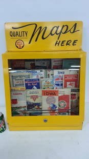
Sold2015Petroliana service station maps display cabinetBeautiful metal countertop maps display cabinet loaded with vintage road maps. Several of the maps are from the 1930's. The map display has a glass front with 3 shelves for displaying maps. A great seSee Sold Price
2022Pre-Columbian Moche Ai apaec Snakes Terra Cotta VesselTitle: Pre-Columbian Moche Ai apaec Snakes Terra Cotta Vessel.Provenance: from a collection of pre-Columbian/ pre-Columbian manner pottery and artifacts representing several cultures from an AmericanSee Sold Price
Sold2022Mongolian Painting- modern.Mongolian Painting- modern. Purchased in the 1990's from someone representing several up and coming Mongolian artists. 10.75" x 8.25"See Sold Price
Sold2018Nine US Mint Boxed Silver DollarsLot of Nine US Mint Boxed Silver Dollars, Representing Several US Armed Services. Consisting of: 2-1991 USO, San Francisco mint. 1-1991 USO, uncirculated, Denver mint. 2-2005 Marine Corps 230th AnniveSee Sold Price
Jun 12Dan Morphy AuctionsGEOLOGY OF THE BLACK AND GRAND RAPIDS OF TEXAS INCLUDING THE EASTERN AND WESTERN CROSS TIMBERS,$100
Jun 07Freeman's | HindmanMURCHISON, Roderick Impey, Sir. The Silurian System. 1839. COMPLETE WITH VERY RARE HAND-COLORED$1,500
Jun 23Schilb Antiquarian Rare Books1790 Life of Jesus Christ Fleetwood Bible ART Miracles Jerusalem MAP Holy Land$42(2 bids)
1 day LeftTrillium Antique Prints & Rare BooksSanson - Map of Canada or New France with the Great Lakes$75(1 bid)
1 day LeftTrillium Antique Prints & Rare BooksSanson - Map of Florida (encompassing most of Southeast North America)$130(2 bids)
1 day LeftTrillium Antique Prints & Rare BooksSanson - Map of the British Isles (Ireland, Scotland, England)$75
4 days LeftJasper521814 Aaron Arrowsmith map. Israelites from Egypt to Canaan through the desert of Arabia Petraea$140
Jun 08Simpson Galleries, LLC.MATTHAUS SEUTTER (1678-1757) A MAP OF THE HOLY LAND AND TWELVE TRIBES, "Terra Sancta Vocatta Que$150
Jun 12Dan Morphy AuctionsINDIAN TERRITORY - DEPARTMENT OF THE INTERIOR GENERAL LAND OFFICE, C.1883$100(1 bid)


![Ohio- Documents Land, etc. c1823-1932 (12) [180896] (1 of 5)](https://p1.liveauctioneers.com/2699/331499/178846665_1_x.jpg?height=282&quality=70&version=1717095214)
![Nevada Ore Deposit Map, 1866 [173205] (1 of 1)](https://p1.liveauctioneers.com/2699/331499/178846263_1_x.jpg?height=282&quality=70&version=1717095214)


![[MAP]. ORTELIUS, Abraham. Africae Tabula Nova. 1592. (1 of 2)](https://p1.liveauctioneers.com/197/329395/177650533_1_x.jpg?height=282&quality=70&version=1715364962)