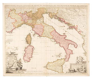
Sold2016Hubert Jaillot Sanson 1692 Map of ItalyFrame: 38" x 26" image sight: 36.25" x 24.25"See Sold Price
Sold2020Nicolas Sanson Map of Morea Greece 1692Nicolas Sanson (1600-1677), "La Moree et les Isles de Zante, Cafalonie, Ste Maure, Cerigo, &c." Paris: Hubert Jaillot, 1692. This hand-colored map depicts Morea, the southern part of Greece, with theSee Sold Price
Sold2024Sanson & Jaillot "Le Royaume de Naples Divisé en Douze Provinces"Map was originally created by Nicholas Sanson d'Abbeville and published by Hubert Jaillot in "Atlas Nouveau" in Paris in 1692See Sold Price
Sold20191694 HUBERT JAILLOT MAP OF ITALY1694 Hubert Jaillot Publishers Paris - Topographic Map of Italy. 19" x 23.50". Laid on silk. As found condition.See Sold Price
Sold2022Alexis Hubert Jaillot and Nicolas Sanson - Map of the Grand Duchy of Moscow, Etching, 1708.Alexis Hubert Jaillot (French, 1632-1712) and Nicolas Sanson (French, 1600-1667) - Map of the White Russia or the Grand Duchy of Moscow, Etching, 1708. Title: Les Estats du Czaar de Russie Blanche ouSee Sold Price
Sold2019Alexis Hubert Jaillot (French 1632-1712) - Map of Asia,Alexis Hubert Jaillot (French 1632-1712) - Map of Asia, 1692. L'Asie Divisee en ses Principales Map, 1692. Map of Asia. 57x87cm. Folds, tears.See Sold Price
Sold2021Antique French Regional MapLa Lorraine qui Comprend les Duches de Lorraine et de Bar. Nicolas Sanson -- Charles Hubert Jaillot, Paris, 1700. Engraving, uncolored.. 21" x 28".See Sold Price
Sold2018RARE 17TH C. SANSON MAP OF LUXEMBOURGAlexis-Hubert Jaillot (c. 1632-1712); Nicolas Sanson (1600-1667) "Le Duche de Luxembourg Divise en Quarter Walon et Allemand....", hand colored engraving, published 1700 from earlier plates, Paris, frSee Sold Price
Sold2018[JAILLOT] MAP OF HUNGARY & SURROUNDINGS'Le Royaume De Hongrie Et Les Estats qui en ont este sujets....La Partie Septentrionale De La Turquie en Europe, by Alexis-Hubert Jaillot (ca. 1632-1712) and Guillaume Sanson (1633-1703), engraving wiSee Sold Price
Sold2020Grp: 5 Maps of Sicily Italy 18th/19th c. JaillotGroup of five 18th and 19th century maps of Sicily. Includes Hubert Jaillot , "La Sicile divisee en ses trois Provinces ou Valees, scavoir Valle Demona, Valle Di Noto, et Valle Di Mazara;" and GuillauSee Sold Price
Sold2021Jaillot 1681 Map of ItalyThis map by Jaillot originated by Nicholas Sanson, the cartographer's predecessor. It depicts the boot of Italy with Albania and Greece. The title cartouche is surrounded by two soldiers, horses, angeSee Sold Price
Sold2020Hubert Jaillot Map South America 1719Hubert Jaillot (1632-1712), "Amerique Meridionale divisee en ses pricipales Parties ou sont distingues les uns des autres les Estats suivant qu'ils appartiennent presentement aux Francois, Castillans,See Sold Price
Sold2019Sanson map of Italy 1701Heading: Author: Sanson, Nicolas Title: L'Italie Divisee Suivant l'Estendue de Toutes ses Sourverainetes... Place Published: Amsterdam Publisher:Pieter Schenk Date Published: 1701 DescSee Sold Price
Sold2017Alexis Hubert Jaillot (French 1632-1712) map of Asia,Alexis Hubert Jaillot (French 1632-1712) map of Asia, "L' Asie, Distinquee en ses principales Parties. 1687", framed and glazed, "L'asie divisee en ses Principales Regions, et ousepeut voir l'estendueSee Sold Price
Sold20241694 Alexis-Hubert Jaillot Highly Detailed Map Of ItalyMap of Italy, the Adriatic, Mediterranean and contiguous islands, including Corsica, Sardinia and SicilySee Sold Price
Sold20201692 - 1696 JAILLOT ALEXIS HUBERT (1632 - 1712)1692 - 1696 JAILLOT ALEXIS HUBERT (1632 - 1712) INCISIONE con coloritura coeva "La Sicilie divisee en ses trois provinces..." (cm 40,5 x 53) tratta dal libro A Amsterdam chez covens et mortier avec prSee Sold Price
Sold20182 Maps: L’Italia + Italia Antiqua.[De Rossi/Sanson/Italy] 2 Maps. ++ Nicholas Sanson. Italia Antiqua cum Itineribus antiquis. Cum Insulis Sicilia Sardinia & Corsica. Rome: Jo. Jacob. De Rubeis. [C. 1690s.] At lower left: “Joannes L�See Sold Price
Sold2016CARTE PARTICULIERE DE VIRGINIE, MARYLAND, PENNSYLVANIA;CARTE PARTICULIERE DE VIRGINIE, MARYLAND, PENNSYLVANIA; ALEXIS-HUBERT JAILLOT (1632-1712), ENGRAVED HAND COLORED MAP, AMSTERDAM AND PAIRIS, PIERRE MORTIER, C.1693-1710 (AN IMPORTANT CHART OF THE MID-ASee Sold Price
Sold2020A LOUIS XIV MAP, "L'Amerique Septentrionale," HUBERTA LOUIS XIV MAP, "L'Amerique Septentrionale," HUBERT JAILLOT, PARIS, 1696, hand colored engraving on paper, "Divisée en ses principals parties, ou sont distingués les uns des autres Les Estats suivaSee Sold Price
Sold2021Alexis-Hubert Jaillot, Le Duche de Brabant, 1692Title: Le Duche de Brabant, qui comprend les Quartiers de Louvain, Brusselles, Anvers et Bosleduc... Cartographer: Alexis-Hubert Jaillot (1632-1712) Copper plate engraving, 1692-93.Two plates (joinedSee Sold Price
Sold2021Alexis-Hubert Jaillot, Duche de Gueldre, 1692Title: La Veluwe, La Betuwe et Le Comte de Zutphe dans le Duche de Gueldre...Cartographer: Alexis-Hubert Jaillot (1632-1712) Copper plate engraving, 1692-93.Two plates (joined) 22 x 29 7/8" (56 x 75.See Sold Price
Sold2021Alexis-Hubert Jaillot, Pays-Bas, 1692Title: Les Provinces des Pays-Bas Catholique. Cartographer: Alexis-Hubert Jaillot (1632-1712) Copper plate engraving, 1692-93.Two plates (joined) 21 1/4 x 34 1/2" (54 x 87.7 cm) plus margins. A fineSee Sold Price
Sold2021Alexis-Hubert Jaillot, Le Comte d'Artois, FranceTitle: Le Comte d'Artois... .Cartographer: Alexis-Hubert Jaillot (1632-1712) Copper plate engraving, 1692-93.Two plates (joined) 21 1/4 x 33 3/8" (53.9 x 84.8 cm) plus margins. A fine and detailed maSee Sold Price
2 days LeftJasper521693 Jaillot Map of the Adriatic Sea and Much of Italy -- Le Golfe de Venise, Avec ses Principaux$500
5 days LeftTrillium Antique Prints & Rare BooksSanson - Map of Canada or New France with the Great Lakes$75
2 days LeftJasper521652 Sanson Map of Parts od Southeast Asia -- Les Isles de la Sonde. Entre Lesquelles sont Sumatra,$200
5 days LeftTrillium Antique Prints & Rare BooksSanson - Map of Florida (encompassing most of Southeast North America)$75(1 bid)
5 days LeftTrillium Antique Prints & Rare BooksSanson - Map of the British Isles (Ireland, Scotland, England)$75
2 days LeftJasper521719 Chatelain Map of the Adriatic and Venice Republic -- Carte de Geographie des Differents Etats$190
Jun 07Freeman's | Hindman[MAP]. ORTELIUS, Abraham. Peregrinationis Divi Pauli Typus Corographicus. 1592.$150(1 bid)
Jun 08Early American History Auctions1776 Map, PARTIE ORIENTALE DU CANADA, AVEC LA NOUVELLE ANGLETERRE, L'ACADIE... by P. Santini, Framed$950
3 days LeftForum AuctionsItaly.- Rizzi-Zannoni (Giovanni Antonio) [Atlante Geografico del Regno di Napoli], c.1788-1812£500
Jun 08Leon GalleryAbraham Ortelius (1527 - 1598) - Indiae Orientalis (Philippines/China/ India/ Southeast Asia)₱200,000
5 days LeftTrillium Antique Prints & Rare BooksBraun & Hogenberg, pub. 1575 - View of Ostia, Italy$100
3 days LeftForum AuctionsItaly.- Zuccagni-Orlandini (Attillio) Atlante Geografico degli stati Italiani...[&] Atlante£1,500


![[JAILLOT] MAP OF HUNGARY & SURROUNDINGS: 'Le Royaume De Hongrie Et Les Estats qui en ont este sujets....La Partie Septentrionale De La Turquie en Europe, by Alexis-Hubert Jaillot (ca. 1632-1712) and Guillaume Sanson (1633-1703), engraving wi](https://p1.liveauctioneers.com/522/124271/63207925_1_x.jpg?height=310&quality=70&version=1530290718)


![[Map] Pologne by Hubert Jaillot: 17th century; framed 49 in. L., 26 in. H.](https://p1.liveauctioneers.com/523/84219/43476547_1_x.jpg?height=310&quality=70&version=1453240168)

![2 Maps: L’Italia + Italia Antiqua.: [De Rossi/Sanson/Italy] 2 Maps. ++ Nicholas Sanson. Italia Antiqua cum Itineribus antiquis. Cum Insulis Sicilia Sardinia & Corsica. Rome: Jo. Jacob. De Rubeis. [C. 1690s.] At lower left: “Joannes L�](https://p1.liveauctioneers.com/179/117971/60557721_1_x.jpg?height=310&quality=70&version=1520636872)


![[MAP]. ORTELIUS, Abraham. Peregrinationis Divi Pauli Typus Corographicus. 1592. (1 of 2)](https://p1.liveauctioneers.com/197/329395/177650535_1_x.jpg?height=282&quality=70&version=1715364962)

![Italy.- Rizzi-Zannoni (Giovanni Antonio) [Atlante Geografico del Regno di Napoli], c.1788-1812 (1 of 2)](https://p1.liveauctioneers.com/5458/329231/177514979_1_x.jpg?height=282&quality=70&version=1715269091)


![Italy.- Zuccagni-Orlandini (Attillio) Atlante Geografico degli stati Italiani...[&] Atlante (1 of 4)](https://p1.liveauctioneers.com/5458/329231/177514980_1_x.jpg?height=282&quality=70&version=1715269091)

