Sold2021Great 1828 map of Penn. by Anthony FinleyVery lovely map of the Keystone State by Anthony Finley. Great hand coloring by county in a style notable to Finley. Copperplate engraving (plate impression still very evident). This is a map that jusSee Sold Price
Sold2022Great 1833 map of Kentucky by Anthony FinleyVery nice impression on this 190-year-old map. State maps from the later Finley atlases are rarely available. A lovely example with just a tiny repaired edge tear at top. Nice representation of mountaSee Sold Price
Sold2022Great example of 1833 Illinois by Anthony FinleyBeautiful and clean map of Illinois from the very scarce 1833 edition of Anthony Finley’s New General Atlas. Maps from later Finley atlases are rarely available. This map was published just afteSee Sold Price
Sold2015Spain & Portugal, 1828Original map, from A New General Atlas, by Anthony Finley, 1828. Dimensions: 20" L x 15" WSee Sold Price
Sold2019Northern AfricaTitle: Northern Africa Date: 1828 Cartographer: YOUNG, J. H. Publisher: Anthony Finley Size: 8Height - 9.8Width Provenance: Detailed map, Plate XXV from his New General atlas. Northern half down to thSee Sold Price
Sold2024Original Illinois 1830 Map, Anthony Finley20" x 15.75". Anthony Finley's map of Illinois, from this scarce 1830 edition, hand colored by counties. Large unnamed territory still belonging to the Native Americans in the upper part of the state.See Sold Price
Sold20232 Maps of Delaware by Finley of Philadelphia & Lucasc.1824 Delaware Map by Anthony Finley, from A New General Atlas. Hand Colored with details of the county seats, roads, towns and settlements, and watershed. I The Cypress Swamp is well drawn along theSee Sold Price
Sold2020FINLEY, ANTHONY. Map of the United States.FINLEY, ANTHONY. Map of the United States. Fine pocket map of the United States engraved by James Hamilton Young. Thin banknote paper, 17x21 inches sheet size, folding into publisher's red roan case wSee Sold Price
Sold2023Scarce and sharp 1833 map of Missouri, Anthony FinleyExtremely scarce map of Missouri from Anthony Finley’s 1833 New General Atlas. Osage, Kickapoo, Delaware and Shawnee tribes shown occupying most of the Ozark Mountains in the lower left quarterSee Sold Price
Sold2023Scarce map of Maine, Anthony Finley 1833Striking and extremely scarce map of Maine from the elusive 1833 New General Atlas by Anthony Finley. Issued when the state had just ten counties. Original hand coloring by county, showing towns, roadSee Sold Price
Sold2022Scarce Heights of Mountains, 1833 Anthony Finley mapStriking and very scarce visual Table of the Comparative Heights of the Principal Mountains in the World. Highly sought-after chart from the elusive 1833 edition of Anthony Finley’s New GeneralSee Sold Price
Sold2023Very scarce 1833 Finley map of IndianaStriking early map of Indiana from the very scarce 1833 New General Atlas by Anthony Finley (maps from later Finley atlases are proving to be very elusive for collectors). This map is an excellent exaSee Sold Price
Sold2024Beautiful 1833 map of Egypt by Anthony FinleyScarce and lovely map of Egypt centered on the Nile River and showing the river settlements as far south as Assouan (Aswan). Shows the pyramids of Geeza and Saccara (Saqqara) and delineates what has bSee Sold Price
Sold2021Anthony Finley (1784-1836) Map of New JerseyCirca 1920, hand colored, Published by Finley and engraved by Young and Delleker. In a period lemon gilt frame. Dimensions: Sight is 11 1/4" x 8 3/4", the frame 17 1/2" x 14 1/2".See Sold Price
Sold2022Very scarce 1833 Finley map of GeorgiaExtremely sharp and scarce map of Georgia from the elusive 1833 New General Atlas by Anthony Finley. This map predates the appearance of Atlanta. Cherokee Indians still present in upper northwest areaSee Sold Price
Sold2016Map of North America...David H. Vance, engraved by J.H. Young. Philadelphia: Anthony Finley, 1825. Engraved map in 5 parts with original hand color in outline. 25 7/8 x 20 1/2 inches sheet, 30 5/8 x 25 1/2 inches framed.See Sold Price
Sold2022Scarce 1833 map of West Indies – fine impressionTrue fully hand colored map of the Caribbean by Anthony Finley features the West Indies and Caribbean Islands. The map extends from southern Florida to northern South America and includes the Bahamas,See Sold Price
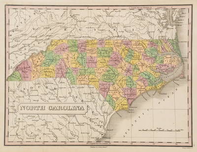
Sold2023Anthony Finley North Carolina Counties MapA Anthony Finley (American, 1784-1834) handcolored engraving depicting the counties within North Carolina and the surrounding areas. Stamped 'Published By A. Finley Phliad.' lower center. Presented inSee Sold Price
Sold2023Lovely and scarce map of Louisiana, Finley 1833Extremely elusive map of Louisiana from a very late Anthony Finley atlas. Later Finley maps are rarely available. Engraving with original hand coloring. Shows early county divisions. Includes historicSee Sold Price
Sold2022Scarce 1833 Finley map of Alabama – near fineExcellent example of Anthony Finley's very scarce 1833 map of Alabama from a rare late edition of his New General Atlas, one of the earliest obtainable separate maps of Alabama. Map is hand-colored bySee Sold Price
Sold20221833 Finley map of Florida – very scarceExcellent example of Florida from the extremely scarce 1833 New General Atlas by Anthony Finley. One of the earliest maps of Florida to appear in a commercial atlas. The map is a significant departureSee Sold Price
Sold2022Illinois State Map AssortmentIllinois State Map Assortment (5) items including 'Illinois' by Anthony Finley, Philadelphia c.1830, depicting land assigned to the Sac and Fox, Winnebago and Ottawa Nations before forcibly removed; 'See Sold Price
Sold2021ESSAY ON ORGANIC DESEASES AND LESIONS OF THE HEARTAn Essay on the Organic Diseases and Lesions of the Heart and Great Vessels, by J.N. Corvisart, published by Anthony Finley, and by Bradford and Read, Boston, 1812. Some foxing, front cover is attacheSee Sold Price
Sold20221833 Jos. Perkins A New General Atlas Map Book1833, written and engraved by Jos. Perkins, publisher - Anthony FinleySee Sold Price
Jun 07Freeman's | Hindman[MAP]. TODESCHI, Pietro. [Nova et Acurata Totius Americae Tabula auct. G.I. Blaeu] America quarta$5,000
3 days LeftSchilb Antiquarian Rare Books1871 Alfred the Great King of England MAP Battle of Ashdown Vikings Thom Hughes$125(3 bids)
5 days LeftJasper521893 Civil War Map of Knoxville Area -- Topographical Map of the Approaches and Defences of$70
Jun 07Freeman's | HindmanHOMANN, Johann Baptist. Amplissimae Regionis Mississipi Seu Provinciae Ludovicianae. Nuremburg, [ca$400(1 bid)
Jun 07Freeman's | Hindman[MORMONS]. MILLROY & HAYES (fl. 1899). Route of the Mormon Pioneers from Nauvoo to Great Salt Lake,$300
2 days LeftLink Auction GalleriesDry, Camille, N. Pictorial St. Louis: The Great Metropolis of the Mississippi Valley. A$1,500
Jun 23Schilb Antiquarian Rare Books1870 BEAUTIFUL Life of Jesus Christ Fleetwood Bible ART Miracles Jerusalem Map$34(2 bids)
2 days LeftTrillium Antique Prints & Rare BooksSanson - Map of Canada or New France with the Great Lakes$75(1 bid)
2 days LeftRipley AuctionsAnthony Louis Popcheff, American (1954-2003), 2 collages, prints, 17"H x 21"W (each)$10
2 days LeftRipley AuctionsAnthony Louis Popcheff, American (1954-2003), untitled, 1985, mixed media, 16 1/2"H x 11 1/2"W$100
6 days LeftLion Heart AutographsRare Redouté ALS On His Last, Great Work, “Le Choix de Plus Belles Fleurs”$1,600(2 bids)
Jun 22Check the Oil Promotions, LLCMr Penn Metal One Quart Motor Oil Can with Quaker Graphics$25(1 bid)
2 days LeftRipley AuctionsAnthony Louis Popcheff, American (1954-2003), 3 green fish / flowers and fish / abstract, print /$10
2 days LeftRipley AuctionsAnthony Louis Popcheff, American (1954-2003), 6 photographs and photographic collages, photographic$50
Jun 23Schilb Antiquarian Rare Books1790 Life of Jesus Christ Fleetwood Bible ART Miracles Jerusalem MAP Holy Land$42(2 bids)
2 days LeftRipley AuctionsAnthony Louis Popcheff, American (1954-2003), blue-violet abstract with bones, 1982 / abstract with$100
2 days LeftRipley AuctionsAnthony Louis Popcheff, American (1954-2003), untitled, mixed media, paint and printing on paper, 22$10


![[MAP]. TODESCHI, Pietro. [Nova et Acurata Totius Americae Tabula auct. G.I. Blaeu] America quarta (1 of 1)](https://p1.liveauctioneers.com/197/329395/177650542_1_x.jpg?height=282&quality=70&version=1715364962)


![[MORMONS]. MILLROY & HAYES (fl. 1899). Route of the Mormon Pioneers from Nauvoo to Great Salt Lake, (1 of 2)](https://p1.liveauctioneers.com/197/329395/177650560_1_x.jpg?height=282&quality=70&version=1715364962)


