Sold2022Fun Map of New Zealand. Wellington, ca. 1940. Pictorial map...Fun Map of New Zealand. Wellington, ca. 1940. Pictorial map of New Zealand, designed by the Charles Haines Advertising Agency of Wellington, and published by the New Zealand Government Tourist DepartmSee Sold Price
Sold2017New York State MapNew York State Map ca. 1940 paper/linen/wood/metal 48.13" W x 1.75" D x 64.75" H Vintage New York social studies map manufactured by Denoyer-Geppert Co. of Chicago, IL, with working pull-down mechanisSee Sold Price
Sold2022PAIGE, Paul. A Map of Cape Cod. East Brewster, MA, ca. 1940...PAIGE, Paul. A Map of Cape Cod. East Brewster, MA, ca. 1940s. Pictorial map showing towns, forests, bridges, lighthouses, and landmarks, marking vacation and tourist attractions, including a key to goSee Sold Price
Sold2020NEW ZEALAND. Shows NZ Company settlements in 1851.TITLE/CONTENT OF MAP: 'New Zealand' Vignettes: Auckland; Mount Egmont from New Plymouth; Wellington. North Island is indicated as "New Ulster or North Island"; the island known today as South Island iSee Sold Price
Sold2024Map of New Zealand Print from 1772 RecordThorndon Fine Prints (Wellington, New Zealand) reprodcued this chart of the 1772 record of New Zealand, which was compiled by Lieutenant James Cook Commander of the Endeavor, using the running surveySee Sold Price
Sold2024Pictorial Map of the United States, 1849PICTORIAL MAP OF THE UNITED STATES 1849. New York: Ensign and Thayer, [ca. 1849.] Sheet 44" x 32.25".*** An attractive hand-colored map providing a view of the United States as it was in the mid-19thSee Sold Price
Sold2020New ZealandPublishers pictorial cover with gilt titles. ix, 241 pages. 75 colour plates with captioned tissue-guards. Fold-out colour map. A lovely copy.; Publishers pictorial cover with gilt titles. ix, 241 pagSee Sold Price
Sold2020Angas, George French Portraits of the New Zealand MaoriWellington: A.H. & A.W. Reed, [1972.] Folio, contemporary half morocco, map, 49 platesSee Sold Price
Sold2018Books: Handbook for European & Oriental Travelers 1896Handbook for European & Oriental Travelers 1896, w/ads for Steamship, Hard cover, Denmark 1923, nice ads & Illustrated New Zealand Luggage Labels, ca. 1940See Sold Price
Sold2021Dutch Nicolaes Visscher I Map of New Amsterdam, ca 1690Nicolaes Visscher I. Map of Northeast with Early View of New York City. Ca. 1690 to 1729. A finely hand-colored example of Nicolaes Visscher I's illustrated map of the Northeast of America with an insSee Sold Price
Sold2023A Decorative Pictorial Map of The New York Worlds Fair by William L. Longyear (American, 1899-1980)A Decorative Pictorial Map of The New York Worlds Fair by William L. Longyear (American, 1899-1980). Framed. Designed and copyrighted by William Longyear. Lithographed in U.S.A by Polygraphic CompanySee Sold Price
Sold20201950s New Zealand Wood / Shell Tiki Lamp**Originally Listed At $150** Oceania, New Zealand, ca. 1950s CE. A fun carved wooden tiki lamp with two large pearlescent shell eyes embedded in its face. Relief carvings on three sides contribute toSee Sold Price
Sold2024John Speed and Francis Lamb "Map of New England and New York", ca. 1676. Hand colored engraved mapJohn Speed and Francis Lamb "Map of New England and New York", ca. 1676. Hand colored engraved map with depictions of animals such as beavers, elk, bears, foxes, and more. Vivid colors. Slight tear upSee Sold Price
Sold2023New Zealand / “The Angler’s Paradise.” Hastings: Pictorial ...New Zealand / “The Angler’s Paradise.” Hastings: Pictorial Publications Ltd., ca. 1950s. Photographic poster of a fisherman in a New Zealand river. 36 ½ x 25”. Linen backeSee Sold Price
Sold2019Nicolao Visscher. Orbis Terrum Nova MapNicolao Visscher (Dutch, 1618-1709). A hand-colored engraved map, circa 1658. Orbis Terrum Nova et Accuratussna Tabula. Showing partial coastlines of New Zealand and Australia. Unframed. 23-1/2 in x 2See Sold Price
Sold2021FRAMED J.H. COLTON MAP OF NORTH AMERICA CA INSETFramed engraving on paper, Map of North America from the Latest Authorities, published by J.H. Colton (Joseph Hutchins Colton, 1800-1893), No. 86 Cedar St., New York, 1846, drawn and engraved by J.M.See Sold Price
Sold2018Philip Trusttum (New Zealand, 1940- )Horse gouache on paper, 1988 signed 130 x 175mm Provenance: Gifted by the artist to Frank and Lyn Corner on the occasion of Lyn speaking at the opening of his 1988 exhibition.See Sold Price
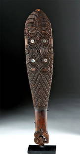
Sold2018Early 20th C. Maori Patu Wood War Club with Shell InlayOceania, New Zealand, ca. 1930s CE. A carved patu (war club), made of dark wood, with inlaid haliotis (abalone) shell forming a cross motif on one side and the eyes of Janus-faced zoomorphic motifs onSee Sold Price
Sold2022(REPUBLIC OF TEXAS.) James Hamilton Young. A New Map of Texas, with the Contiguous American &(REPUBLIC OF TEXAS.) James Hamilton Young. A New Map of Texas, with the Contiguous American & Mexican States. Hand-colored engraved map of Texas with inset text panels relating information on its riveSee Sold Price
Sold2023MITCHELL'S NEW MAP of TEXAS, OREGON & CALIFORNIA1846 Philadelphia, S. Augustus Mitchell. hardcover leather bound. 5 1/4 x 3 1/4 inches. Map unfolded 22 x 20 1/2 inches and presented in a custom frame 23 1/2 x 22 inches (overall)See Sold Price
Sold2022MITCHELL, S. AUGUSTUS. A New Map of Texas, Oregon and California.MITCHELL, S. AUGUSTUS. A New Map of Texas, Oregon and California. Engraved pocket map of the American territories west of the Mississippi River. 22¾x21 inches overall, ample margins; strong origiSee Sold Price
Sold2018Young New Map of TexasA New Map of Texas with the contiguous American and Mexican States. James Hamilton Young. Engraved map with original hand color. Philadelphia: S. Augustus Mitchell, 1839. 13 x 15 1/2 inches visible, 1See Sold Price
Sold2021A New Map of Texas, Oregon and California"A New Map of Texas, Oregon and California with the Regions Adjoining" by S. Augustus Mitchell, engraving with hand-coloring, 1st edition, published Philadelphia, 1846; framed together with original bSee Sold Price
2 days LeftFreeman's | Hindman[HARDY, Thomas]. -- WINDLE, C.A. The Wessex of Thomas Hardy. Edmund H. New, illustrator. 1902.$200
BonhamsPeter McIntyre (New Zealand 1910-1995) The Rangitikei river near Mangaweka, New Zealand, 1973 (T...£5,000
Jun 13Julien's AuctionsThe Hobbit: The Desolation of Smaug | Erebor Treasure Jewel Plaque and "An Unexpected Journey"$100
Jun 26Potter & Potter AuctionsRYAN, Anne (American, 1889-1954). Dancer. [Ca. 1940]. Oil o...$225(3 bids)
Jun 15Crescent City Auction GalleryTwelve Stations of the Cross Wall Plaques, ca. 1930-1940, H.- 50 1/2 in., W.- 33 3/8 in., D.- 3 7/8$400
3 days LeftPotter & Potter Auctions[PEPPER’S GHOST]. Strange & Wilson’s New Entertainment. Not...$200(1 bid)
2 days LeftFreeman's | HindmanCOOK, James, Captain. The Three Voyages of Captain James Cook. 1842.$175(2 bids)
BonhamsCHURCHILL (WINSTON S.) An unsmoked 'Winston Churchill La Corona' cigar, with box and supporting ...£800
Jun 23Schilb Antiquarian Rare Books1848 Emory Military Reconnaissance 1ed California MAP Indians Texas New Mexico$3(3 bids)
Jun 14DuMouchellesWilliam H. Gamble (American, B. 1863) Hand Colored Engraving, Ca. 1863, "County Map of Michigan And$50(1 bid)
Jun 14Crescent City Auction GalleryAfter Marie Adrien Persac (French/Louisiana, 1823-1873), "Plantations on the Mississippi River from$325
Jun 12Jasper52A plan of the operations of the King's army… in New York… FADEN/STEDMAN 1794 map$6,500


![Pictorial Map of the United States, 1849: PICTORIAL MAP OF THE UNITED STATES 1849. New York: Ensign and Thayer, [ca. 1849.] Sheet 44" x 32.25".*** An attractive hand-colored map providing a view of the United States as it was in the mid-19th](https://p1.liveauctioneers.com/3532/326332/175680404_1_x.jpg?height=310&quality=70&version=1713150771)

![Angas, George French Portraits of the New Zealand Maori: Wellington: A.H. & A.W. Reed, [1972.] Folio, contemporary half morocco, map, 49 plates](https://p1.liveauctioneers.com/94/178654/90043159_1_x.jpg?height=310&quality=70&version=1599751213)


![[MAP]. SPEED, John. A New Mappe of the Romane Empire. 1676. (1 of 2)](https://p1.liveauctioneers.com/197/329395/177650541_1_x.jpg?height=282&quality=70&version=1715364962)
![[HARDY, Thomas]. -- WINDLE, C.A. The Wessex of Thomas Hardy. Edmund H. New, illustrator. 1902. (1 of 3)](https://p1.liveauctioneers.com/197/329395/177650387_1_x.jpg?height=282&quality=70&version=1715364962)


![RYAN, Anne (American, 1889-1954). Dancer. [Ca. 1940]. Oil o... (1 of 3)](https://p1.liveauctioneers.com/928/330686/178765822_1_x.jpg?height=282&quality=70&version=1716992685)


![[PEPPER’S GHOST]. Strange & Wilson’s New Entertainment. Not... (1 of 1)](https://p1.liveauctioneers.com/928/329228/177514542_1_x.jpg?height=282&quality=70&version=1715272280)


