Sold2024EARLY 18TH C. DUTCH CHART OF PACIFIC OCEAN BY FREDERIK DE WIT (1629-1706) WITH CALIFORNIA AS AN"Magnuum Mare del Zur, cum Insula California, De Groote Zuyd-Zee en't Eylandt California; Gedruck't Amsterdam by Frederick De Wit ince Calver Street". Handcolored copper engraving. Engraver: Romeyn deSee Sold Price
Sold2023North Pole, 'Polkarte'; Frederik De Wit (1610-1698) - "Poli Arctici, et circumiacentium terrarumArtis/Title: North Pole, 'Polkarte'; Frederik De Wit (1610-1698) - "Poli Arctici, et circumiacentium terrarum descriptio novissima" - 1661-1680 Date: 1670 Material: Paper Dimensions: 62 cm x 67 cm DesSee Sold Price
Sold2023Frederik De Wit Map of Hungary and the Balkans.This antique hand-colored map is matted and mounted to a cardstock backing. The map is dated 1686, and is accredited to Frederici (Frederik) de Wit. The text is in Latin. It looks to be in overall gooSee Sold Price
Sold2024Frederik De Wit Map Of SpainIn the region of Catalonia and the counties of Ruscinone and CerretaniaSee Sold Price
Sold2021FREDERIK DE WIT Zealand MapFREDERIK DE WIT Zealand Map, inscriptions to piece in Latin, subject an overhead map, measures 21 1/8 x 24 5/8 inches, yellow wooden frame, surface wear to frame, broken glass to lower portion of piecSee Sold Price
Sold2023[MAP] DE WIT, F. NOVA ORBIS TABULA IN LUCEM EDITAde Wit, Frederik. NOVA ORBIS TABULA, IN LUCEM EDITA. (Amsterdam: circa 1670s.) Beautiful map in exquisite full handcolouring, with elaborate corner scenes illustrating the four seasons and the Zodiac,See Sold Price
Sold2017WIT, Frederick de (1630-1706). [Composite Atlas].WIT, Frederick de (1630-1706). [Composite Atlas]. Amsterdam: F. de Wit, [n.d. ma circa 1680]. Bellissimo atlante composito con oltre 117 mappe di cui la maggior parte a doppia pagina e colorate all'epSee Sold Price
Sold20211690 ANTIQUE MAP OF LIMBURG NETHERLANDS by Frederik de1690 ANTIQUE MAP OF LIMBURG NETHERLANDS TABULA DUCATUS LIMBURCH ET COMITATUS VALCKENBURCH IN LUCEM EDITA A.F.WIT Copper-plate engraved map printed on laid paper,hand colored, no text on the verso By FSee Sold Price
Sold2022MAP, South America, WitNorthwestern South America & Central America. Frederick de Wit, Novae Hispaniae, Chili, Peruviae, et Guatimalae Littorae, from Orbis Maritimus ofte Zee Atlas, 1680 (circa). Hand Color. This handsome sSee Sold Price
Sold2021Mauritz Frederik De Haas Oil, Rocky CoastMauritz Frederik De Haas (Dutch/American 1832-1895) Rocky Coast with Figures Along the Rocks and Sails at Sea, oil on canvas, signed M.F.H.De Haas, N.A. lower right, framed in 19thc. frame under glassSee Sold Price
Sold2017De Wit Portolan Sea Chart of EuropeTotius Europae Victoria... Frederic De Wit (1630-1706). Engraved map with original hand color. Amsterdam, 1675. 20 x 35 1/2 inches sheet, 27 1/2 x 43 inches framed. “The most striking and decorativeSee Sold Price
Sold2022De Wit - Nova Orbis Tabula In Lucem Edita, MapFrederick De Wit (circa 1629-1706), Nova Orbis Tabula In Lucem Edita, A.F. De Wit, published by Covens and Mortier, Amsterdam, circa 1720, in two sheets, engraving on laid paper, double hemisphere vieSee Sold Price
Sold2023Mauritz Frederik De Haas (NY,Dutch,1832-1895) oil painting antiqueARTIST: Mauritz Frederik Hendrick De Haas (New York, Holland, 1832 - 1895) TITLE: Sunset Seascape with Shipwreck MEDIUM: oil on canvas CONDITION: Relined. Few scratches. Few scattered inpaitings. ARTSee Sold Price
Sold2022De Wit, Map of North and South America, c. 1720Property of a Private Collector, Hilton Head Island, SC Description: Frederick De Wit (circa 1629-1706), Nova Orbis Tabula In Lucem Edita, A.F. De Wit, Amsterdam: Covens and Mortier, c. 1720, publSee Sold Price
Sold2022Theo de Wit, ArmchairTheo de Wit Armchair EMS OverschieThe Netherlands, c. 1935chrome-plated steel, plywood, lacquered plywood 29.5 h × 20 w × 19 d in (75 × 51 × 48 cm) TSee Sold Price
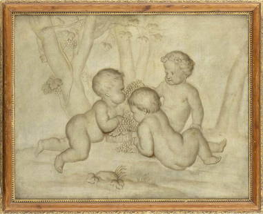
Sold2023JACOB DE WIT (Amsterdam, 1695-1754), ATTRIBUTED TOThree puttos with bunches of grapes Oil on canvas, cm. 65x82. FramedSee Sold Price
Sold2022Jean Paul de Wit (Belgium,1851-?) oil painting antiqueARTIST: Jean Paul de Wit (Belgian, 1851 - ???) NAME: Portrait of Woman MEDIUM: oil on canvas CONDITION: Some craquelure. Minor paint losses along edges. No visible inpaint under UV light. SIGHT SIZE:See Sold Price
SoldJacob De Wit (Dutch, 1695-1754) A Flying Putto (framed 46.5 x 40.3 x 5.0 cm (18 5/16 x 15 7/8 x ...Jacob De Wit (Dutch, 1695-1754) A Flying Putto unsigned; attributed by Dr. A.W.F.M. Meij, (former) curator of Museum Boijmans-van Beuningen, Rotterdam (according to an inscription on the backing paperSee Sold Price
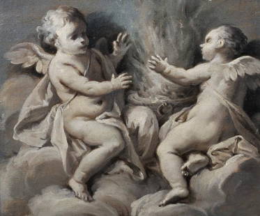
Sold2019Attributed to Jacob de Wit (c.1695-1754) Dutch.Attributed to Jacob de Wit (c.1695-1754) Dutch. 'Allegory of Summer', en grisaille, Oil on Canvas, 7.75" x 9", and a companion piece, 'Putti with a Scythe and Hay', a Pair (2).See Sold Price
2023Nelson Mandela and Frederik de Klerk Signed Commemorative PostcardNelson Mandela and Frederik de Klerk Signed Commemorative Postcard with Additional Signatures from South African Fighter Pilots and Additional 1994 Newsweek Magazine - Displayed in Museum-Quality CustSee Sold Price
Sold2017(MAP, SICILY) DE WIT, FREDERICK. Insula sive regnumMAP, SICILY by DE WIT, FREDERICK, Insula sive regnum Siciliae urbibus praecipuis exornatum. Amsterdam, circa 1680. Hand-colored engraved map of Sicily. With inset plans of Messina, Milazzo and PalermoSee Sold Price
Sold2017de Wit: Map of Southeast Asia, 1670Map: Tabula Indiae Orientalis Cartographer: Frederick De Wit Place & Date: Amsterdam / 1670 Size: 22 1/4" x 18 1/4" Condition: light overall age-toning A highly decorative and beautifully colored lateSee Sold Price
Sold2016An important map of Asia, c1680 by Frederick De WitAn important map of Asia, c1680 by Frederick De Wit depicting the area of Asia, including China, Japan, Tibet, India, Russia, Persia, Arab and more (center folding area repair), 19.5"x23"See Sold Price
Jun 06Austin Auction Gallery(2) JOHN DE WIT (20TH C.) ORIENT & FLUME ART GLASS SPIRAL PAPERWEIGHT VASES$150
2 days LeftTrillium Antique Prints & Rare BooksDe Jode, Rare, pub. 1593 - Map of Kingdom of Napoli, Italy (Neapolitani Regni exacta ac diligens$130(3 bids)
2 days LeftTrillium Antique Prints & Rare BooksDe Jode, Rare, pub. 1593 - Map of Hainut, Belgium (Hannoniae Comitatus Descriptio)$100(1 bid)
Jun 02Schilb Antiquarian Rare Books1698 Blaise PASCAL Provincial Letters Witchcraft Sorcery JESUIT Philosophy RARE$125(3 bids)
Jun 07Freeman's | HindmanHAUY, Rene-Just. Traite de Mineralogie. 1801. FIRST EDITION, SIGNED BY PUBLISHER.$500
5 days LeftJasper521764 Bellin Map of Northern Portion of Martinique -- Partie Septentrionale de la Martinique$45
5 days LeftJasper521764 Bellin Map of Port Antonio, Jamaica -- Plan des Havres de Port Antonio et de Saint Francois$70
5 days LeftJasper521764 Bellin Chart of Three South Haitian Bays -- Carte des Bayes du Mesle des Flamands et de$40
5 days LeftJasper521764 Bellin Map of Eastern Guadeloupe in the Lesser Antilles -- Partie Orientale de l'Isle de la$80
Featured6 days LeftJasper52Carte L’Asie. Asia. Mughal Empire. Oirat Kingdom. Tartary. VAUGONDY 1750 map$280


![Frederik DE WIT - [Atlas]. First Image](https://p1.liveauctioneers.com/828/27981/10670364_1_x.jpg?height=300&quality=1&version=1326189346&width=300)
![Frederik DE WIT - [Atlas]. First Image](https://p1.liveauctioneers.com/828/27981/10670364_1_x.jpg?height=300&quality=95&version=1326189346&width=300)


![[MAP] DE WIT, F. NOVA ORBIS TABULA IN LUCEM EDITA: de Wit, Frederik. NOVA ORBIS TABULA, IN LUCEM EDITA. (Amsterdam: circa 1670s.) Beautiful map in exquisite full handcolouring, with elaborate corner scenes illustrating the four seasons and the Zodiac,](https://p1.liveauctioneers.com/8124/310027/165853624_1_x.jpg?height=310&quality=70&version=1700184289)
![WIT, Frederick de (1630-1706). [Composite Atlas].: WIT, Frederick de (1630-1706). [Composite Atlas]. Amsterdam: F. de Wit, [n.d. ma circa 1680]. Bellissimo atlante composito con oltre 117 mappe di cui la maggior parte a doppia pagina e colorate all'ep](https://p1.liveauctioneers.com/3662/102842/52581030_1_x.jpg?height=310&quality=70&version=1492593376)