Sold2023Framed Colored Print Of Historical Map Of Stuttgart In 1592-View After Jonathan SauterThis lot contains a framed colored print of a Historical Map Of Stuttgart In 1592-View After Jonathan Sauter. The print itself is approx 13 1/2" x 32" while the frame is approx 18 1/2" x 3See Sold Price
Sold20191600s View of Mexico Hand Colored Map PrintNot sure when this was printed, but probably 18th or early 19th century. It has been in its current for about 100 years. Image size is 9 x 10.5, but is larger with border. Framed to 12.75 x 14.75. ImaSee Sold Price
Sold2017German Moscovia Map PrintTitled "Mosvavw", hand colored, note on verso "Braun and Hogenburg, Cologne c. 1585 The earliest obtainable map or view of Moscow". Map, 15-1/2" x 21", framed 22-1/2" x 28"See Sold Price
Sold2022LeRoy Neiman Colored Serigraph Framed PrintsTo be offered on Thursday, 22 September 2022 Las Vegas Grand Prix 1972, Grand Prix de Monaco, Ferrari on the Beach; Las Vegas Grand Prix 1972, Grand Prix de Monaco, Ferrari on the BeachSee Sold Price
Sold2022Rare Tony Sarg Colored Map of New Hope, Pennsylvania 1941Rare Tony Sarg (1880-1942) Colored Map of New Hope, Pennsylvania 1941, depicting George Washington crossing the Delaware River among other local points of interest 19 in. x 25 in. Framed 27.5 in. x 33See Sold Price
Sold2018Hand drawn and colored map of Massachusetts includingHand drawn and colored map of Massachusetts including Cape Cod, Plymouth, Kingston, Duxbury, etc. professionally matted and framed. sight size: 15 1/2" x 19 1/2" Provenance: Property from Credit SuiSee Sold Price
Sold2016ANTIQUE NEW-FRANCE HAND COLORED MAPANTIQUE NEW-FRANCE HAND COLORED MAP, H 27 1/2" IMAGE, W 20 1/2":Framed, measures H.30" x 23" overall.See Sold Price
Sold2024Three 19th C. Patriotic Americana Framed Printscomprising Currier and Ives,"Grand National Union Banner for 1864", together with Felton,"View of the Bunker Hill Monument" and J. Baker,"Battle of Lexington". Largest frame size: 15 1/2" high, 21" wiSee Sold Price
Sold2024Mixed Prints & Maps 18th-20th Cent. Lot of 70 Engravings & LithosLot of 70 Engravings, Lithos and Maps. Incl Botanical & Fungi, Natural History, Portraits, Views, Charts, Anatomy/Medical etc. Paper Size: Up to 14 x 11.5 inch (36 x 29cm) Some faults, Good ConditionSee Sold Price
Sold2016A Map of the United States & MexicoHenry Tanner (1786-1858). New York: Tanner, 1850. Hand-colored Pocket Map. 23 x 29 inches visible, 38 x 39 1/2 inches framed.See Sold Price
Sold2017After Rembrandt, Etching - View of AmsterdamAfter Rembrandt, framed etching of a landscape with buildings and a windmill. Possibly British Museum sanctioned print of "View of Amsterdam from the Northwest" (Kadjik). [Art: 3 1/2" x 5"; Frame: 12"See Sold Price
Sold2022Kawase Hasui Height of sheet 7 1/4 x width 18 3/4 in., 18.3 x 47.5 cm.Kawase Hasui (Japanese, 1883-1957) Densensui no zenkei (Panoramic View of Daisensui Pond) from the set Mitsubishi Fukagawa bettei (Pictures of Mitsubishi Fukagawa Villa), 1920 colored woodblock printSee Sold Price
Sold2018ATTRIBUTED TO WILLEN BLAEU 2 ENGRAVED MAPSATTRIBUTED TO WILLEN BLAEU, 2 HAND COLORED ENGRAVED MAPS, "NAVA BELGICA" & "MAPPA AESTIVARUM", 15 1/4" X 19 3/4" & 16" X 21" DATES OF PRINTING ARE UNKNOWN; FRAMED. ARNOLD KLEIN FRAMING LABEL.See Sold Price
2022Blaeu, Johannes (Netherlands, 1596-1673) "The New World Map" Double Hemisphere World Map C. 1664Nova et Accuratissima Totius Terrarum Orbis Tabula Translated "The New World Map", Hand Colored w/ Elaborately Decorated Spandrels.   Sight View 16" x 21-1/2", Overall View 21" x 25-1/2"See Sold Price
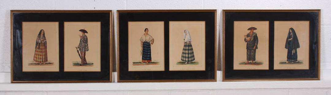
Sold2017Six 19th C Philippine Fashion Costume ColoredSix 19th C Philippine Fashion Costume Colored Lithographs. Framed under glass in pairs. Size: 15" x 20.5" frame, 10.25 x 7.5" each view.See Sold Price
Sold2021c 1730 Seutter Map: Novi Belgii, in America ...Historic Maps c. 1730 Historic Rare Earlier State of Seutter's Important American Northeast Map & New York City Restitutio View c. 1730 Hand-Colored Copper-Engraved Map titled, "Recens Edita totius NoSee Sold Price
Sold2021KAWASE HASUI (1883-1957)KAWASE HASUI (1883-1957) Taisho (1912-1926) era, 1924 An oban tate-e and an oban yoko-e print (both framed); the first entitled Osaka Takatsu (View from Takatsu in Osaka); the second entitled KinosakiSee Sold Price
Sold2024Two John Gould Hummingbird Prints20th century. Each having been colored nicely and framed in conforming frames. H29 1/4" W23 1/4"See Sold Price
Sold2016Beautifully Colored Jan Van Loon World MapOrbis Terrarum Nova... Jan Van Loon (c. 1611-1686). Engraved map with original hand color in full. London: Moses Pitt, 1680. 17 3/4 x 21 inches visible, 28 1/4 x 31 3/4 inches framed. A fine example oSee Sold Price
Sold2021Dutch Nicolaes Visscher I Map of New Amsterdam, ca 1690Nicolaes Visscher I. Map of Northeast with Early View of New York City. Ca. 1690 to 1729. A finely hand-colored example of Nicolaes Visscher I's illustrated map of the Northeast of America with an insSee Sold Price
Sold2022NEIL LEIFER (B. 1942): MUHAMMAD ALImachine-print color photograph, matted and framed under acrylic; signed lower right, numbered 269/350 lower left; aerial view of Muhammad Ali celebrating after his round-two knockdown of Cleveland WilSee Sold Price
Sold2022(lot of 6) Utagawa Hiroshige woodblock prints(lot of 6) Utagawa Hiroshige woodblock prints, each from the One Hundred Famous Views of Edo, framed and glazed, 13.25"h. x 9"w.See Sold Price
Sold2024Braun & Hogenberg, pub. 1575 - View of Strasbourg, FranceThis extraordinary, originally hand-colored engraving is from Georg Braun & Frans Hogenberg's Civitates Orbis Terrarum or Atlas of the Cities of the World. This was from a combined Latin and French edSee Sold Price
Sold2024Braun & Hogenberg, pub. 1575 - View of Orleans, FranceThis extraordinary, originally hand-colored engraving is from Georg Braun & Frans Hogenberg's Civitates Orbis Terrarum or Atlas of the Cities of the World. This was from a combined Latin and French edSee Sold Price
1 day LeftArarity AuctionsC. G. Reichard "Charte des Osmanische Reichs in Asien" 1804 Antique Hand Colored Framed Map$50
1 day LeftArarity AuctionsThomson's 1817 Hand Colored Map Comparative Heights of the World's Great Mountains$50
7 days LeftRbfineartsHistorical Map of the State of Kentucky by Karl Smith 1933 Daniel Boone & Companions View$30(2 bids)
Jun 07Freeman's | Hindman[MAP]. ORTELIUS, Abraham. Peregrinationis Divi Pauli Typus Corographicus. 1592.$150(1 bid)
6 days LeftCottone AuctionsBowles and Carver, "A South-West View of the City of New York in North America" and "A South-East$150
6 days LeftFreeman's | Hindman[SHERMAN, William T. (1820-1891)]. [BRADY, Mathew (1822-1896), photographer]. Sherman and his Genera$1,000
6 days LeftFreeman's | Hindman[CIVIL WAR]. BARNARD, George N. (1819-1902), photographer. View on Tennessee River looking towards$200
5 days LeftThe Rug LifeANDRE CASTAIGNE (1860-1930) ORIGINAL, HAND COLORED COLLOTYPE TITLED EXECUTION OF A DESERTER, 18.5IN$300
5 days LeftThe Rug LifeANDRE CASTAIGNE (1860-1930) ORIGINAL, HAND COLORED COLLOTYPE TITLED CAPTAIN AND TROOPERS, 1861,$250
5 days LeftThe Rug LifeORIGINAL, HAND COLORED PHOTOGRAVURE TITLED OFFICERS OF THE FRENCH CONTINGENT, 18.5IN x 24.5IN (47cm$250


![[MAP]. ORTELIUS, Abraham. Turcici Imperii Descriptio.1592. (1 of 2)](https://p1.liveauctioneers.com/197/329395/177650538_1_x.jpg?height=282&quality=70&version=1715364962)
![[MAP]. ORTELIUS, Abraham. Romani Imperii Imago. 1592. (1 of 2)](https://p1.liveauctioneers.com/197/329395/177650537_1_x.jpg?height=282&quality=70&version=1715364962)
![[MAP]. ORTELIUS, Abraham. Peregrinationis Divi Pauli Typus Corographicus. 1592. (1 of 2)](https://p1.liveauctioneers.com/197/329395/177650535_1_x.jpg?height=282&quality=70&version=1715364962)


![[SHERMAN, William T. (1820-1891)]. [BRADY, Mathew (1822-1896), photographer]. Sherman and his Genera (1 of 3)](https://p1.liveauctioneers.com/197/329785/177758265_1_x.jpg?height=282&quality=70&version=1716403914)


![[CIVIL WAR]. BARNARD, George N. (1819-1902), photographer. View on Tennessee River looking towards (1 of 2)](https://p1.liveauctioneers.com/197/329785/177758317_1_x.jpg?height=282&quality=70&version=1715625218)


