Sold2020First separate map of El CerritoHeading: (California - El Cerrito) Author: Title: Map of the City of El Cerrito and Vicinity, Contra Costa County, California, showing official zoning Place Published: No place Publisher: Date PSee Sold Price
Sold2019Map of East Bay Cities and other districts. Oakland, ElTitle: Map of East Bay Cities and other districts. Oakland, El Cerrito, Piedmont, Berkeley, Alameda, San Leandro Publication Date: ©1926 Cartographer: Thomas Brothers Publisher: Thomas Brothers Size:See Sold Price
Sold2022Military.- Montgomery (Bernard Law, Viscount of ) El Alamein to the River Sangro, one of 265 copiesMilitary.- Montgomery (Bernard Law, first Viscount of Alamein) El Alamein to the River Sangro, number 86 of 265 copies signed by the author to title, portrait frontispiece, plates, maps, original blacSee Sold Price
Sold2017Ortelius: First Map of Japan in European Atlas, 1595Title: Iaponiae Insulae Descriptio. Ludoico Teisera Auctore. [first map of Japan published in European atlas] Map maker: Abraham Ortelius, Theatrum Orbis Terrarum Place and Year: Antwerp, 1595 DimensiSee Sold Price
Sold2022Einstein (Albert) Die Grundlage der allgemeinen Relativitätstheorie, first separate edition,Einstein (Albert) Die Grundlage der allgemeinen Relativitätstheorie, first separate edition, scattered foxing and ink ownership inscription to title, contemporary half-cloth, spine ends and corneSee Sold Price
Sold2018Map, United States, 1784, first map of the nationMap, United States, 1784,"Carte Des Etats-Unis De L'Amerique Suivant le Traite de Paix de 1783. Dediee et Presentee A.S. Excellence M. Benjamin Franklin Ministre Pleinipotentaire des Etats-Unis", theSee Sold Price
Sold2020Bret Harte's Heathen Chinee first separate editionHeading: Author: Harte, F. Bret Title: The Heathen Chinee Place Published: Chicago Publisher:Western News Company Date Published: 1870 Description: 9 lithographed cards & tSee Sold Price
Sold2022Copper engraving, original color First map with contemporary information, Aegypti recentiorCopper engraving, original color First map with contemporary information, Aegypti recentior descriptio, drawn by Ortelius for his pocket atlas: “Epitome THEATRI ORTELIANI: praecipuarum orbis. .&See Sold Price
Sold20201st separate map of Paramount, California, 1962Heading: (California - Paramount) Author: Title: Paramount California "The City of Progress" Place Published: Santa Monica, Cal. Publisher:Bay Area Publications Date Published: 1962 DeSee Sold Price
Sold2018First separate edition of Nicholas Coxe's The FowlerHeading: Author: Coxe, Nicholas Title: The Fowler. Containing Rules for Taking Every Species of Land and Water Fowl...Such as, Woodcocks, Felfares, Pigeons, Magpies... Likewise, Instructions for theSee Sold Price
Sold2022SHAW, George Bernard. Cashel Byron's Profession. [London:] The Modern Press, 1886. FIRST SEPARATESHAW, George Bernard (1856-1950). Cashel Byron's Profession. [London:] The Modern Press, 1886.   Tall 8vo (235 x 147 mm). Blank leaf at end. (Some spotting.) Original blue printed wrappers (someSee Sold Price
Sold2018Norwich (England). First map of the cityReserve Reduced! Title/Content of Map: Norwich (England). First map of the city Date: 1572-1617 Size: 20x15 1/2” from Civitates Orbis Terrarum by Braun & Hogenberg, Cologne. Hand colored Reserve: $4See Sold Price
Sold2022(MORMONS.) Reply of Joseph Smith to the Letter of J. A. B--- of A---n House, New York.(MORMONS.) Reply of Joseph Smith to the Letter of J. A. B--- of A---n House, New York. 24 pages. 12mo, disbound; minor wear and soiling. Liverpool: R. Hedlock and T. Ward, [1844] First separate editioSee Sold Price
2021Bradford's Map of Texas 1835/36"Bradford's Map of Texas, 1st Separate Map of Texas to Appear in an Atlas" by Thomas G. Bradford, copper engraving with hand-colored outlines, published Boston, 1835/1836, together with accompanying aSee Sold Price
Sold2022World.- Plancius (Petrus) Orbis Terrarum Typus de Integro Multis in Locis Emendatus auctore PetroWorld.- Plancius (Petrus) Orbis Terrarum Typus de Integro Multis in Locis Emendatus auctore Petro Plancio, double-hemisphere world map, after Mercator's world map of 1587, and the first map to show JaSee Sold Price
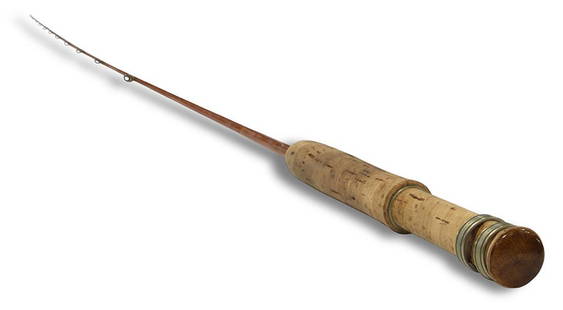
Sold2020A rare Per Brandin bamboo fly fishing rodA rare Per Brandin bamboo fly fishing rod, the 7-foot bamboo fishing rod for a #3 line, 1992, El Cerrito, CA, with translucent olive wraps and semi-hollow construction, marked 1/92 indicating that thiSee Sold Price
Sold2020Disneyland 1958a Map - First Full Size ReleaseHere's a beautiful piece of Disney History. A rare 1958a Map. This was the first Map full-size souvenir map released at Disneyland. It was a rolled map, not folded like most of the 1958 Maps. The MAPSee Sold Price
Sold2023"Europa das ein Drittheil der Erden nach Gelegenheit unsern Zeiten", Sebastian Munster, ca. 1569"Europa das ein Drittheil der Erden nach Gelegenheit unsern Zeiten". (First Map of the Continent of Europe). Basle, ca. 1569. Sebastian Munster (German 1488-1552), was a cartographer, cosmographer, anSee Sold Price
Sold2022Blaeu Novus Brasiliae Typus, c. 1640BLAEU, Willem Janszoon (1571-1638). Novus Brasiliae Typus. Engraved map with original hand color in full. Amsterdam. c. 1640. 18" x 21 7/8" sheet. Fine old color example of Blaeu's first map of BrazilSee Sold Price
Sold2019Ireland.- Ortelius (Abraham) Eryn. Hiberniae,Ireland.- Ortelius (Abraham) Eryn. Hiberniae, Britannicae Insulae, Nova Descriptio. Irlandt, the first map of Ireland to include any geographic details, based on Mercator's 1564 wall map of the BritisSee Sold Price
Sold2022Ireland.- Ortelius (Abraham) Eryn. Hibernaie, Britannicae Insuale, engraved map, [c. 1590].NO RESERVE Ireland.- Ortelius (Abraham) Eryn. Hibernaie, Britannicae Insuale, the first map of Ireland to include any geographic details, based on Mercator's 1564 wall map of the British Isles and isSee Sold Price
Sold2022Rontgen, Wilhelm, Eine neue Art von Strahlen [About a new kind of rays],Offprint of Rontgen's announcement of the discovery of the X-ray, Original paper wrappers, first issue of the "2. Auflage," with the wrappers of the first separate printing dated "Ende 1895". This isSee Sold Price
Sold2021HOMANN, ENGLISH TERRITORIES IN NORTH AMERICA, MAPJohann Baptist Homann (German, 1664-1724). "Dominia Anglorum in America Septentrionali" - circa 1740, engraving with hand coloring. Note: Map depicts four separate maps including plans of Virginia, MaSee Sold Price
Sold2021Scarce c1610 map of Scotland, Wm. HoleFirst map of Scotland made by an Englishman in England. Fine map of Scotland engraved by William Hole (one of the earliest English engravers) for the first illustrated edition of Camden’s Britannia,See Sold Price
2 days LeftHolabird Western Americana CollectionsAuriferous Gravels of Sierra Nevada of CA, J. D. Whitney, 1880 [183996]$200
Jun 13Swann Auction Galleries(UNITED STATES.) James Hamilton Young; and Samuel Augustus Mitchell. Traveller's Guide Through the$450
3 days LeftFreeman's | HindmanJOHNSON, Samuel. Irene: A Tragedy. As it is Acted at the Theatre Royal in Drury-Lane. 1749. FIRST$200
20 hrs LeftJasper521581 Ortelius Map of Tuscany [with] Corsica [with] Ancona -- Senensis Ditionis, Accurata Descrip [on$140
BonhamsAFRICA MUNSTER (SEBASTIAN) Africa Lybia Morenlandt mit allen königreichen so zu unsern zeit...£300
4 days LeftLeon GalleryGiovanni Battista Ramusio (1485 - 1557) Giacomo Gastaldi (1500 - 1566) - Terza Ostro Tavola (The₱1,300,000
BonhamsETHIOPIA ORTELIUS (ABRAHAM) Presbiteri Iohannis, sive, Abissinorum Imperii Descriptio, [1573 or ...£300
Jun 13Swann Auction Galleries(NEW ENGLAND.) Johannes van Keulen. Pas-Kaart vande Zee Kusten van Niew Nederland Anders Genaamt$2,200
5 days LeftWorthington GalleriesFirst Edition Hand-colored Map THE NORTH RIDING OF YORKSHIRE by Robert Morden$50
2 days LeftFreeman's | HindmanHEMINGWAY, Ernest. Men Without Women. FIRST EDITION, FIRST PRINTING. In the FIRST ISSUE DUST JACKET.$500(1 bid)


![Ortelius: First Map of Japan in European Atlas, 1595: Title: Iaponiae Insulae Descriptio. Ludoico Teisera Auctore. [first map of Japan published in European atlas] Map maker: Abraham Ortelius, Theatrum Orbis Terrarum Place and Year: Antwerp, 1595 Dimensi](https://p1.liveauctioneers.com/5584/108292/55552479_1_x.jpg?height=310&quality=70&version=1503667951)


![SHAW, George Bernard. Cashel Byron's Profession. [London:] The Modern Press, 1886. FIRST SEPARATE: SHAW, George Bernard (1856-1950). Cashel Byron's Profession. [London:] The Modern Press, 1886.   Tall 8vo (235 x 147 mm). Blank leaf at end. (Some spotting.) Original blue printed wrappers (some](https://p1.liveauctioneers.com/197/243560/126320649_1_x.jpg?height=310&quality=70&version=1649297800)

![(MORMONS.) Reply of Joseph Smith to the Letter of J. A. B--- of A---n House, New York.: (MORMONS.) Reply of Joseph Smith to the Letter of J. A. B--- of A---n House, New York. 24 pages. 12mo, disbound; minor wear and soiling. Liverpool: R. Hedlock and T. Ward, [1844] First separate editio](https://p1.liveauctioneers.com/199/261738/136414927_1_x.jpg?height=310&quality=70&version=1663269541)


![Ireland.- Ortelius (Abraham) Eryn. Hibernaie, Britannicae Insuale, engraved map, [c. 1590].: NO RESERVE Ireland.- Ortelius (Abraham) Eryn. Hibernaie, Britannicae Insuale, the first map of Ireland to include any geographic details, based on Mercator's 1564 wall map of the British Isles and is](https://p1.liveauctioneers.com/5458/248003/128645375_1_x.jpg?height=310&quality=70&version=1652282230)
![Rontgen, Wilhelm, Eine neue Art von Strahlen [About a new kind of rays],: Offprint of Rontgen's announcement of the discovery of the X-ray, Original paper wrappers, first issue of the "2. Auflage," with the wrappers of the first separate printing dated "Ende 1895". This is](https://p1.liveauctioneers.com/6656/268202/140247424_1_x.jpg?height=310&quality=70&version=1668029675)


![Auriferous Gravels of Sierra Nevada of CA, J. D. Whitney, 1880 [183996] (1 of 10)](https://p1.liveauctioneers.com/2699/331494/178785579_1_x.jpg?height=282&quality=70&version=1717094654)


![Wah To Yah & The Taos Trail [181869] (1 of 5)](https://p1.liveauctioneers.com/2699/331494/178785312_1_x.jpg?height=282&quality=70&version=1717094654)
![Cartographers Silver Medal [179723] (1 of 2)](https://p1.liveauctioneers.com/2699/331499/178846389_1_x.jpg?height=282&quality=70&version=1717095214)
![[MAP]. ORTELIUS, Abraham. Turcici Imperii Descriptio.1592. (1 of 2)](https://p1.liveauctioneers.com/197/329395/177650538_1_x.jpg?height=282&quality=70&version=1715364962)


![Jacob Monk 1853 Map of North America [173506] (1 of 11)](https://p1.liveauctioneers.com/2699/331495/178785775_1_x.jpg?height=282&quality=70&version=1717094933)
![1581 Ortelius Map of Tuscany [with] Corsica [with] Ancona -- Senensis Ditionis, Accurata Descrip [on (1 of 1)](https://p1.liveauctioneers.com/5584/331064/178466435_1_x.jpg?height=282&quality=70&version=1716924723)
![[MAP]. ORTELIUS, Abraham. Africae Tabula Nova. 1592. (1 of 2)](https://p1.liveauctioneers.com/197/329395/177650533_1_x.jpg?height=282&quality=70&version=1715364962)


![Maps of Asia & India, c1800's (2) [180164] (1 of 2)](https://p1.liveauctioneers.com/2699/331495/178785787_1_x.jpg?height=282&quality=70&version=1717094933)

