Sold20181675 John Ogilby Britannia Atlas England HUGE FOLIOS1675 John Ogilby Britannia Atlas England HUGE FOLIOS Roads Scotland Wales 2v In 1675, John Ogilby, a famed Scottish cartographer, began working on his famous road atlas known as ‘The Britannia.’ BSee Sold Price
Sold2019Senex & Ogilby 1719 Road Map. London to Montgomery"The Road from London to Montgomery in North Wales" Copper Engraved Map Published 1719, London for "An Actual Survey of all the Principal Roads of England and Wales" by John Ogilby and John Senex. PapSee Sold Price
Sold2020Senex & Ogilby 1719 Road Map. London to Montgomery"The Road from London to Montgomery in North Wales" Copper Engraved Map Published 1719, London for "An Actual Survey of all the Principal Roads of England and Wales" by John Ogilby and John Senex. PapSee Sold Price
Sold2022England.- Ogilby (John) Ogilby's Road Maps of England and Wales from Ogilby's 'Britannia', 1675,NO RESERVE England.- Ogilby (John) Ogilby's Road Maps of England and Wales from Ogilby's 'Britannia', 1675, double- and whole-page maps, original cloth, Osprey, [1971]; and 16 others British TopographSee Sold Price
Sold20241645 Road Map by John Ogilby Buckingham to Bridgnorth Plate 23An antique road map showing the first accurate survey of the roads of England and Wales. This map shows the continuation of the extended road from Buckingham to Bridgnorth. 1 of over 100 maps publisheSee Sold Price
Sold2017[Maps] Britannia Depicta, 1720Bowen, Emanuel. BRITANNIA DEPICTA OR OGILBY IMPROV'D; BEING A CORRECT COPPY OF MR. OGILBY'S ACTUAL SURVEY OF ALL YE DIRECT & PRINCIPAL CROSS ROADS IN ENGLAND AND WALES. London: Tho. Bowles, 1720. 8vo.See Sold Price
Sold2023England, 17th century. John Ogilby (1600-1676). Printed in London, 1671. An execptional intaglioEngland, 17th century. John Ogilby (1600-1676). Printed in London, 1671. An execptional intaglio print of Vizlipuztli Idolum Mexicanorum (Huitzilopochtli Mexican Deity). Overall good condition; foxingSee Sold Price
Sold2022British Isles.- Taylor (Thomas) England Exactly Described or a Guide to Travellers, In a CompleatBritish Isles.- Taylor (Thomas) England Exactly Described or a Guide to Travellers, In a Compleat Sett of Most Correct Mapps of Counties in England ... according to Mr. Ogilby's Survey, double page tiSee Sold Price
Sold2022Leigh, Samuel 1826 Lot of 4 British County MapsCopper Engraved Map Published 1826, London for "Leigh's New Pocket Road-Book of England, Wales and Part of Scotland..." by Samuel Leigh. Maps Engraved by Sidney Hall. Paper Size: 5.5 x 3.5 inch (14 xSee Sold Price
Sold2022Leigh, Samuel 1826 Lot of 12 British County Maps of WalesCopper Engraved Maps Published 1826, London for "Leigh's New Pocket Road-Book of England, Wales and Part of Scotland..." by Samuel Leigh. Maps Engraved by Sidney Hall. Paper Size: 5.5 x 3.5 inch (14 xSee Sold Price
Sold2022Leigh, Samuel 1826 Lot of 4 British County MapsCopper Engraved Map Published 1826, London for "Leigh's New Pocket Road-Book of England, Wales and Part of Scotland..." by Samuel Leigh. Maps Engraved by Sidney Hall. Paper Size: 5.5 x 3.5 inch (14 xSee Sold Price
Sold2022Leigh, Samuel 1826 Lot of 4 British County MapsCopper Engraved Map Published 1826, London for "Leigh's New Pocket Road-Book of England, Wales and Part of Scotland..." by Samuel Leigh. Maps Engraved by Sidney Hall. Paper Size: 5.5 x 3.5 inch (14 xSee Sold Price
Sold2022Leigh, Samuel 1826 Lot of 4 British County MapsCopper Engraved Map Published 1826, London for "Leigh's New Pocket Road-Book of England, Wales and Part of Scotland..." by Samuel Leigh. Maps Engraved by Sidney Hall. Paper Size: 5.5 x 3.5 inch (14 xSee Sold Price
Sold2022Leigh, Samuel 1826 Lot of 3+ British County MapsEngraved Title Page plus 3 Copper Engraved Maps Published 1826, London for "Leigh's New Pocket Road-Book of England, Wales and Part of Scotland..." by Samuel Leigh. Maps Engraved by Sidney Hall. PaperSee Sold Price
Sold2022Leigh, Samuel 1826 Lot of 4 British County MapsCopper Engraved Map Published 1826, London for "Leigh's New Pocket Road-Book of England, Wales and Part of Scotland..." by Samuel Leigh. Maps Engraved by Sidney Hall. Paper Size: 5.5 x 3.5 inch (14 xSee Sold Price
Sold2022Leigh, Samuel 1826 Lot of 4 British County MapsCopper Engraved Map Published 1826, London for "Leigh's New Pocket Road-Book of England, Wales and Part of Scotland..." by Samuel Leigh. Maps Engraved by Sidney Hall. Paper Size: 5.5 x 3.5 inch (14 xSee Sold Price
Sold2022Leigh, Samuel 1826 Lot of 4 British County MapsCopper Engraved Map Published 1826, London for "Leigh's New Pocket Road-Book of England, Wales and Part of Scotland..." by Samuel Leigh. Maps Engraved by Sidney Hall. Paper Size: 5.5 x 3.5 inch (14 xSee Sold Price
Sold2022Leigh, Samuel 1826 Lot of 4 British County MapsCopper Engraved Map Published 1826, London for "Leigh's New Pocket Road-Book of England, Wales and Part of Scotland..." by Samuel Leigh. Maps Engraved by Sidney Hall. Paper Size: 5.5 x 3.5 inch (14 xSee Sold Price
Sold2022[ANTIQUE MAPS] OGILBY--YORK TO WHITBY, SCARBORO 1675[ANTIQUE MAPS] OGILBY, John "YORK TO WHITBY, SCARBORO" London, UK 1675. 50X36cm. Scrolled road map. Framed. Hand-coloured. The complete route, with a spur from New Malton to Scarborough. Frame not incSee Sold Price
Sold20241665 VIRGIL Aeneid Georgics Eclogues Bucolics Mythology RARE John Ogilby ENGLISH1665 VIRGIL Aeneid Georgics Eclogues Bucolics Mythology RARE John Ogilby ENGLISH “Audaces fortuna iuvat- (Fortune favors the bold).” ― Virgil Virgil is regularly considered one of tSee Sold Price
Sold2023'Fable of the Old Lion'' by Dirk Stoop/John OlgibyEngland, 17th century. A plate from Aesop's Fables by Dirk Stoop and John Ogilby. Dates to c.1655. Toning/light staining throughout; tearing.See Sold Price
Sold20181814 ATLAS Maps of England & Wales Scotland Color Nav1814 ATLAS Maps of England & Wales Scotland Color Navigation Travel John Cary An incredible atlas consisting of 42 color maps of Great Britain by John Cary. The atlas covers cities in England, Wales,See Sold Price
Sold20201798 1ed Cary ROADS New Itinerary England Wales1798 1ed Cary ROADS New Itinerary England Wales Topography Atlas Travel Guide John Cary was a famous English cartographer from the 18th-century. Cary gained his reputation as a map maker from his workSee Sold Price
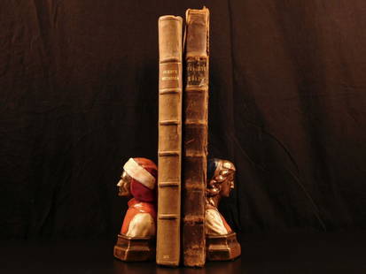
Sold2021Rare book titled "Poems On Various Subjects, ReligiousRare book titled "Poems On Various Subjects, Religious And Moral" 1793 edition, by Phillis Wheatley "Negro servant to Mr. John Wheatley of Boston, in New England.". Published in "Albany: Re-printed, FSee Sold Price
20 hrs LeftRapid Estate Liquidators and Auction GalleryAntique Book - "Mr. Punch's Pocket Book for 1874"$50(1 bid)
4 days LeftFreeman's | HindmanMURCHISON, Roderick Impey, Sir. The Silurian System. 1839. COMPLETE WITH VERY RARE HAND-COLORED$1,500
6 days LeftWorthington Galleries2v. Set DICTIONNAIRE UNIVERSEL DES SYNONYMES DE LA LANGUE FRANCAISE, 1810$10
Jun 11John Moran Auctioneers, Inc.KAWS, Barry (Twist) McGee, Margaret Kilgallen, Shepard Fairey, Ruby Rose Neri, Jared (Geso) Costa,$7,500
Jun 23Schilb Antiquarian Rare Books1675 Imitation of Christ Thomas a Kempis Italian Paris Faraudi Pocket-size RARE$52(3 bids)


![England.- Ogilby (John) Ogilby's Road Maps of England and Wales from Ogilby's 'Britannia', 1675,: NO RESERVE England.- Ogilby (John) Ogilby's Road Maps of England and Wales from Ogilby's 'Britannia', 1675, double- and whole-page maps, original cloth, Osprey, [1971]; and 16 others British Topograph](https://p1.liveauctioneers.com/5458/257239/133765092_1_x.jpg?height=310&quality=70&version=1659622051)

![[Maps] Britannia Depicta, 1720: Bowen, Emanuel. BRITANNIA DEPICTA OR OGILBY IMPROV'D; BEING A CORRECT COPPY OF MR. OGILBY'S ACTUAL SURVEY OF ALL YE DIRECT & PRINCIPAL CROSS ROADS IN ENGLAND AND WALES. London: Tho. Bowles, 1720. 8vo.](https://p1.liveauctioneers.com/3532/111460/57224161_1_x.jpg?height=310&quality=70&version=1509131847)


![[ANTIQUE MAPS] OGILBY--YORK TO WHITBY, SCARBORO 1675: [ANTIQUE MAPS] OGILBY, John "YORK TO WHITBY, SCARBORO" London, UK 1675. 50X36cm. Scrolled road map. Framed. Hand-coloured. The complete route, with a spur from New Malton to Scarborough. Frame not inc](https://p1.liveauctioneers.com/8321/253807/131946541_1_x.jpg?height=310&quality=70&version=1657215628)


![[John Newton interest] Halyburton, Thomas (1 of 1)](https://p1.liveauctioneers.com/94/330664/178342131_1_x.jpg?height=282&quality=70&version=1716466933)


