Sold20181814 ATLAS Maps of England & Wales Scotland Color Nav1814 ATLAS Maps of England & Wales Scotland Color Navigation Travel John Cary An incredible atlas consisting of 42 color maps of Great Britain by John Cary. The atlas covers cities in England, Wales,See Sold Price
Sold20181850 McDowall Diamond Maps ATLAS Geography England1850 McDowall Diamond Maps ATLAS Geography England Scotland Ireland World Color A collection of 19th-century McDowall maps. These four maps are extremely desirable, hand-colored views. Maps include: �See Sold Price
Sold2024Becker, F. P. C1845 Pair of Maps. England & Wales and ScotlandSteel Engraved Map Published C1845, London for "A Complete and Universal English Dictionary" by the Rev. James Barclay and B. B. Woodward. Maps by F. P. Becker. Outline hand color. Paper Size: 11 x 8See Sold Price
Sold2022Antique Map Print - Ireland - England - Wales - ScotlandSet of 4 Map Prints. Antique lithographic map originates from "Letts's Popular Atlas", being a series of maps delineating the whole surface of the globe, with many special and original features; and aSee Sold Price
Sold2020Bryce, James 1881 Lot of 3 Maps of the British IslesEngland & Wales, Scotland and Physical Map of the British Isles. Lithograph Maps Published 1881, London for ""The International Atlas and Geography..." by James Bryce. Maps by Edward Weller & John BarSee Sold Price
Sold2020Bryce, James 1881 Pair of Maps England/Wales & ScotlandEngland & Wales, Scotland and Physical Map of the British Isles. Lithograph Maps Published 1881, London for ""The International Atlas and Geography..." by James Bryce. Maps by Edward Weller & John BarSee Sold Price
Sold2019Cornwell & Dower 1849 Lot of 7 Miniature MapsIncl America Continent, Solar System, Mexico/West Indies, Oceania, Ireland, Scotland, and England/Wales. Steel Engraved Maps Published 1849, London for "A School Atlas" by James Cornwell. Maps by JohnSee Sold Price
Sold2018MAPS: Roads of England and Wales c1860 color mapMAPS: Roads of England and Wales c1860 color map, The Roads of England and Wales, with the whole of Scotland, showing the Distances between each Town, and from London; also the tracks of the Steam NavSee Sold Price
Sold2022Times Atlas 1895 Mixed Lot of 6 Large MapsIncl Mediterranean, England/Wales, Italy, Balkans, Scotland and South America. Lithograph Map Published 1895, London for "The Times Atlas" Centre fold as published. Paper Size: Mostly 21 x 16 inch (53See Sold Price
Sold2019Bryce, James 1881 Lot of 4 Maps of the UK, ScotlandIncl England/Wales, British Isles and Scotland. Lithograph Maps Published 1881, London for ""The International Atlas and Geography..." by James Bryce. Maps by Edward Weller & John Bartholomew. UncommoSee Sold Price
Sold2019Blackie & Weller 1882 Lot of 4 Maps. UK & IrelandIncl Ireland South Part, Scotland South Part, British Islands and The North Sea, and England & Wales. Lithograph Maps Published 1882 by Blackie & Son, London for "The Comprehensive Atlas & Geography oSee Sold Price
Sold2015TEESDALE, HENRY. New British AtlasTEESDALE, HENRY. New British Atlas Containing a *Complete Set of County Maps...Preceded by General Maos of England, Ireland, Scotland, North & South Wales, the Whole Carefully Revised and CorrecteSee Sold Price
Sold20221814 Needlework Map of England and WalesEllen Slow worked this map in the year of our lord Dated 1814. Frame 25 x 24.5 inchesSee Sold Price
Sold2020Lyttleton, George 1810 Map of England, Scotland, Wales"An Accurate Map of England, Scotland, and Wales" Copper Engraved Map Published 1810, London for "The History of England..." by George Courtney Lyttleton. Folds as issued. Paper Size: 18 x 14 inch (46See Sold Price
Sold2020Lyttleton, George 1810 Map of England, Scotland, Wales"An Accurate Map of England, Scotland, and Wales" Copper Engraved Map Published 1810, London for "The History of England..." by George Courtney Lyttleton. Folds as issued. Paper Size: 18 x 14 inch (46See Sold Price
Sold2019Lyttleton, George 1810 Map of England, Scotland, Wales"An Accurate Map of England, Scotland, and Wales" Copper Engraved Map Published 1810, London for "The History of England..." by George Courtney Lyttleton. Folds as issued. Paper Size: 18 x 14 inch (46See Sold Price
Sold2019Walker, John 1795 Pair Maps of Scotland, England, WalesCopper Engraved Maps Published 1795, London for "Elements of Geography, and of Natural and Civil History" by John Walker. Centre fold as published. Paper Size: 10 x 8.5 inch (26 x 22cm) Minor toning aSee Sold Price
Sold2017British Isles: C England Wales Scotland Ireland MapBritish Isles: Counties. England Wales Scotland Ireland. Tallis/rapkin 1851 Map. Vignettes: London; Edinburgh; Dublin. Approx 36.5 x 26.5cm, 14.5 x 10.25 inches (Large). Antique engraved map by J RapkSee Sold Price
Sold2019Physical Map of England & Wales With Part of ScotlandTitle/Content of Map: Physical Map of England & Wales With Part of Scotland Date: 1848 Cartographer: HUGHES, W. (DRAWN BY) Publisher: THE NATIONAL SOCIETY Size: 17.5Height - 12.8Width Published by theSee Sold Price
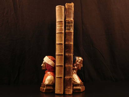
Sold20181675 John Ogilby Britannia Atlas England HUGE FOLIOS1675 John Ogilby Britannia Atlas England HUGE FOLIOS Roads Scotland Wales 2v In 1675, John Ogilby, a famed Scottish cartographer, began working on his famous road atlas known as ‘The Britannia.’ BSee Sold Price
Sold2020Grp: Assorted Maps of EuropeLarge group of assorted 18th and 19th century maps of Europe. Includes two overall maps of Europe, one map of England and Wales, one map of Scotland, one map of France, one map of Greece, two maps ofSee Sold Price
Sold2022England & Wales.- Bingley (James) The OfficialNO RESERVE England & Wales.- Bingley (James) The Official Travelling Map of England and Wales with part of Scotland, engraving with original hand-colouring, 595 x 485 mm (23 1/2 x 19 in), dissected anSee Sold Price
Sold2020Antique Picot & Co map of England and WalesAntique Picot & Co framed map of England and Wales with part of Scotland. Overall size 37"h x 31"w overall. Paper sight size 27 1/2"h x 21 1/4"w. Published by Picot & Co London and Manchester.See Sold Price
Sold2021Antique 18th C Map, England, Johann Baptist HomannOriginal decorative copperplate engraving on hand-laid paper with strike impression, map of England and Wales in full wash color, cartouche with title, two coats of arms and vignette, titled "Magnae BSee Sold Price
Jun 02Schilb Antiquarian Rare Books1897 History of British Empire England Scotland Canada James II MAPS India 6v$1
5 days LeftJasper521890s Cram Map of Vermont [verso] New Hampshire -- Vermont [verso] New Hampshire$30
Jun 02Schilb Antiquarian Rare Books1803 King Charles II Escape from Worcester English Civil War Samuel Pepys RARE$2(2 bids)
3 days LeftSchilb Antiquarian Rare Books1869 ATLAS 42 MAPS America Africa Australia GERMANY Switzerland Sydow RARE$155(4 bids)
May 18RbfineartsWilliam Russell (Sir William) Flint 1880-1969 "The Farm Girl And The Nymphs" Watercolor$100(1 bid)
13 hrs LeftRail & Road AuctionsSeven Pieces of Steamship Silver and China - Detroit & Cleveland, New England, New South Wales, and$40
6 days LeftThe Benefit Shop Foundation Inc.Fredrick Reynolds Sgd Age Of Innocence Mezzotint$20(2 bids)
7 days LeftZikorn Arts & History ObjectsLeon Uris, Jill Uris: Jerusalem, 1981 Signed First Edition$50
Jun 02Schilb Antiquarian Rare Books1797 Polwhele DEVONSHIRE Devon England Exeter Archbishops South Wales HUGE FOLIO$1
May 23Potter & Potter Auctions[BRITISH CAVALRY]. British Officer’s Sabretache, 10th (Prin...$1,000
May 22Hannam's Auctioneers LtdThe Complete Atlas of Modern, Classical and Celestial Maps, together with Plans of the Principal Cit£240
13 hrs LeftNew England Auctions - Fred GiampietroScottish Regency Wrought Iron Bench, circa 1820$200(5 bids)
13 hrs LeftNew England Auctions - Fred GiampietroPair of 19th C Fireclay Urns from Michael Douglas’ Former Estate, Signed J&M Craig$275(5 bids)


![1890s Cram Map of Vermont [verso] New Hampshire -- Vermont [verso] New Hampshire (1 of 2)](https://p1.liveauctioneers.com/5584/328338/176911596_1_x.jpg?height=282&quality=70&version=1715113718)


![[EPHEMERA]. Group of Booklets, Magazines, Postcards, Brochu... (1 of 1)](https://p1.liveauctioneers.com/928/328184/176813372_1_x.jpg?height=282&quality=70&version=1714496988)


![[BRITISH CAVALRY]. British Officer’s Sabretache, 10th (Prin... (1 of 3)](https://p1.liveauctioneers.com/928/328184/176813488_1_x.jpg?height=282&quality=70&version=1714496988)
![[POTTERY]. [WELLESLEY, Arthur, First Duke of Wellington (17... (1 of 1)](https://p1.liveauctioneers.com/928/328184/176813332_1_x.jpg?height=282&quality=70&version=1714496988)


