Sold2022EASTERN HEMISPHERE. Climatic regions according to the ancients. MALLET 1683 mapTITLE OF THE MAP: 'Climats selon les anciens' (De la Sphere) DATE PRINTED: 1683 IMAGE SIZE: Approx Overall page size 13 x 21cm approximately (5 x 8 inches); image size 10.5 x 14.5cm approximately (4 xSee Sold Price
Sold2022EASTERN HEMISPHERE. Circles of Longitude. Southern continent. MALLET 1683 mapTITLE OF THE MAP: 'Cercles de Longitude' (De la Sphere) Tenerife is marked. Partial outline of Terra Australis, the hypothesised southern continent, is shown. The outline of Australia is shown incomplSee Sold Price
Sold2023SUB-SAHARAN AFRICA. 'Ancienne Ethiopie'. Ancient Ethiopia. MALLET 1683 old mapTITLE OF THE MAP: 'Ancienne Ethiopie' (De L'Afrique) Central, Eastern & Southern Africa plus Madagascar DATE PRINTED: 1683 IMAGE SIZE: Approx Overall page size 13 x 21cm approximately (5 x 8 inches);See Sold Price
Sold2022NORTH & CENTRAL ASIA ANCIENT. Scythia Serique Sarmatia Siberia. MALLET 1683 mapTITLE OF THE MAP: 'Partie Septentrionale de L'Ancienne Asie; Scythie de la la M. Imaus; Region Serique; Sarmatie Asiatique; Scythie deca le M.Imaus' (De L'Asie) Scythia (Ancient Greek: Σκ	See Sold Price
Sold2017Mallet: Antique Map of the Eastern Hemisphere, 1683Title/Content of Map: 'Paralleles de Latitude' Date Printed: 1683 Image Size: Approx Overall page size 13 x 21cm approximately (5 x 8 inches); image size 10.5 x 14.5cm approximately (4 x 5.5 inches) TSee Sold Price
Sold2017Mallet: Antique Map of the Eastern Hemsiphere, 1683Map Title: 'Ancien Continent avec plusieurs Isles, Oceans et Mers' Partial outline of Terra Australis, the hypothesised southern continent, is shown. Asia Africa Europe, Eastern Hemisphere. Date PrintSee Sold Price
Sold2022HEAVENS & EARTH. 5 zones according to Thales & Pythagoras. MALLET 1683 old mapTITLE OF MAP (NOT PRINTED ON THE PAGE):[Covenance des Zones du Ciel & de la Terre] (De la Sphere) Shows Australia with a very inaccurate (and incomplete) shape. Partial outline of Terra Australis, theSee Sold Price
Sold2022HELIOCENTRIC SOLAR SYSTEM. Earth's movement as per Copernicus. MALLET 1683 mapTITLE OF MAP (NOT PRINTED ON THE PAGE):[Raisons de Copernic touchant le troisiéme mouvement de la Terre] (De la Sphere) Illustrates the changing seasons according to the angle of the earth's axisSee Sold Price
Sold2022ANCIENT LEVANT. 'Syrie Ancienne'. Syria Palestine Cyprus Jordan. MALLET 1683 mapTITLE OF THE MAP: 'Syrie Ancienne' (De L'Asie) DATE PRINTED: 1683 IMAGE SIZE: Approx Overall page size 13 x 21cm approximately (5 x 8 inches); image size 10.5 x 14.5cm approximately (4 x 5.5 inches) TSee Sold Price
Sold2017Ancient World Divided Between Noah's 3 Sons 1683 MapAncient World. Divided Between Noah's 3 Sons. Japeth Shem Ham. Mallet 1683 Map. Title of the Map: 'la Terre Partagee Aux Trois Enfans De Noe; Ancienne Division De La Terre En Divers Peuples' australiaSee Sold Price
Sold2021Mallet, Alain 1683 Antique Map. Ancient Libya"Ancienne Libye Interievre" Copper Engraved Map Published 1683, Paris for "Description de l'Univers" First Edition by Alain Manesson Mallet. French text to verso. Paper Size: 8 x 5 inch (20 x 13cm) SoSee Sold Price
Sold2022BALKANS. Illyria 'Illyrie'. Danube basin. Pannonia Mysia. MALLET 1683 old mapTITLE OF THE MAP: 'Illyrie' (De L'Europe) In classical antiquity, Illyria was a region in the western part of the Balkan Peninsula inhabited by the Illyrians. The Romans conquered the region in 168 BCSee Sold Price
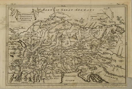
Sold20201750 c. Map of Eastern Alps Region in Ancient Times --Title: 1750 c. Map of Eastern Alps Region in Ancient Times -- The Countries of Vindelicia, Rhaethia & Noricum Cartographer: G Sale et al Year/Place: 1750 c., London Size: 7.8 X 11.8 in. Additional InfSee Sold Price
Sold2018Mallet, Alain Manesson 1683 HCol Map of India & China"Ancienne Region des Sines" Hand Coloured Copper Engraved Map Published 1683, Paris for "Description de l'Univers" by Alain Manesson Mallet. French text to verso. Paper Size: 8 x 5 inch (20 x 13cm) GoSee Sold Price
Sold2021Map of the Polar Regions - Arctic DiscoveriesMap of the Polar Regions Showing Recent Discoveries With Mercator Map of the Eastern Hemisphere on verso Cartographer: George Franklin Cram Dated: Circa 1900See Sold Price
Sold2017Ancient World Maps, Mela Posidonius & Ptolemy 1683 MapAncient World. Maps by Mela, Posidonius & Ptolemy. Mallet 1683 Old Antique. Title of the Map: 'globe De Mella; Globe De Posidonius; Globe De Ptolomee' date Printed: 1683 image Size: Approx Overall PagSee Sold Price
Sold2017Mallet: Antique Map of Ancient India, 1683Title/Content of Map: 'Inde Ancienne a l'Occident du Gange' Ancient India from the Ganges westwards Date Printed: 1683 Image Size: Approx Overall page size 13 x 21cm approximately (5 x 8 inches); imagSee Sold Price
Sold2017Map of Ancienne ArabieANCIENT ARABIA. Saudi UAE Oman Qatar Petra. 'Ancienne Arabie'. MALLET 1683 map Size: Approx Overall page size 13 x 21cm approximately (5 x 8 inches); image size 10.5 x 14.5cm approximately (4 x 5.5 inSee Sold Price
Sold2018Mallet: Antique Map of Ancient North Italy, 1683Title of the Map: 'Partie Septentrionale de l'Ancienne Italie' ANCIENT ITALY NORTH. Gallia Cisalpina. Ancienne Italie Septent. Date Printed: 1683 Image Size: Approx Overall page size 13 x 21cm approxiSee Sold Price
Sold2018Mallet: Antique Map of Ancient Northern Italy, 1683Title of the Map: 'Partie Septentrionale de l'Ancienne Italie' ANCIENT ITALY NORTH. Gallia Cisalpina. Ancienne Italie Septent. Date Printed: 1683 Image Size: Approx Overall page size 13 x 21cm approxiSee Sold Price
Sold2017Mallet: Antique Map of Ancient Northern Italy, 1683Title of the Map: 'Partie Septentrionale de l'Ancienne Italie' ANCIENT ITALY NORTH. Gallia Cisalpina. Date Printed: 1683 Image Size: Approx Overall page size 13 x 21cm approximately (5 x 8 inches); imSee Sold Price
Sold2017Mallet: Antique Map of World Planisphere, 1683Map Title: 'Planisphere de Turquet; Planisphere de Bertius; Planisphere d'Arzael' 5 hemispheres on 1 plate. California appears as an island on the Arzeal projection. Twof the plates shown Terra AustraSee Sold Price
Sold2017Mallet: Antique Map of the Western Hemisphere, 1683Title/Content of Map: 'Nouveau Continent avec plusieurs Isles et Mers' shows California as an Island. Date Printed: 1683 Image Size: Approx Overall page size 13 x 21cm approximately (5 x 8 inches); imSee Sold Price
Sold2018Mallet: Antique Map of France in Regions, 1683TITLE OF THE MAP: 'France' DATE PRINTED: 1683 IMAGE SIZE: Approx Overall page size 13 x 21cm approximately (5 x 8 inches); image size 10.5 x 14.5cm approximately (4 x 5.5 inches) TYPE: Original 17th cSee Sold Price
Jun 12Dan Morphy AuctionsGEOLOGY OF THE BLACK AND GRAND RAPIDS OF TEXAS INCLUDING THE EASTERN AND WESTERN CROSS TIMBERS,$100
Jun 12Dan Morphy AuctionsINDIAN TERRITORY - DEPARTMENT OF THE INTERIOR GENERAL LAND OFFICE, C.1883$100
1 day LeftJasper521693 Jaillot Map of the Adriatic Sea and Much of Italy -- Le Golfe de Venise, Avec ses Principaux$500
Jun 08Simpson Galleries, LLC.J.H. Young (1792-1870) AN AMERICAN FEDERAL PERIOD MAP, "Mitchell's Travellers Guide Through the$500
5 days LeftTrillium Antique Prints & Rare BooksSanson - Map of Canada or New France with the Great Lakes$75
3 days LeftPandora AuctionsVery Unusual Vintage Brutalist European Silver & Baltic Amber Rosary$45(1 bid)
3 days LeftPandora AuctionsPair of Vintage Mid-Century Modern Brutalist Israeli Judaica Brass Candlesticks$25
Jun 14DuMouchellesRigobert Bonne (French, 1727-1794) Hand Colored Engraving Ca. 18th Century, Les Etats Unis De$50


![HEAVENS & EARTH. 5 zones according to Thales & Pythagoras. MALLET 1683 old map: TITLE OF MAP (NOT PRINTED ON THE PAGE):[Covenance des Zones du Ciel & de la Terre] (De la Sphere) Shows Australia with a very inaccurate (and incomplete) shape. Partial outline of Terra Australis, the](https://p1.liveauctioneers.com/5584/265755/138774165_1_x.jpg?height=310&quality=70&version=1666735665)
![HELIOCENTRIC SOLAR SYSTEM. Earth's movement as per Copernicus. MALLET 1683 map: TITLE OF MAP (NOT PRINTED ON THE PAGE):[Raisons de Copernic touchant le troisiéme mouvement de la Terre] (De la Sphere) Illustrates the changing seasons according to the angle of the earth's axis](https://p1.liveauctioneers.com/5584/265755/138774175_1_x.jpg?height=310&quality=70&version=1666735665)