Sold2024Crams Township and Railroad Map of Pennsylvania-1898This is a Crams Township and Railroad Map of Pennsylvania dated 1898. Booklet contains an excellent multi-paneled fold-out map of the state of Pennsylvania that shows and lists all railroads in the stSee Sold Price
Sold2024Crams Township and Railroad Map of New York-1890This is a Crams Township and Railroad Map of New York dated 1890. Contains an excellent multi-paneled fold-out color map of the state with all railroads listed. Only a few very minor tears/frays at thSee Sold Price
Sold2018Cram's RailRoad & Township Map of Washington.Title: Cram's RailRoad & Township Map of Washington. Publication Date: 1881 Cartographer: GEO. F. CRAM Publisher: GEO. F. CRAM Size: 15.5X19 Published for Geo. F. Cram. Proprietor of the Western Map DSee Sold Price
Sold20181898 Railroad Map of Pennsylvania PRR Internal Affairs1898 Railroad Map of Pennsylvania, published by the Department of Internal Affairs, 1898, folded, in a canvas slip case.See Sold Price
Sold2016Cram's Lithographed Map of Oregon, 1881Cram's Railroad and Township Map of Oregon. George F. Cram. Hand-colored Lithographed Map. Chicago: Cram, 1881. from 'The Standard American Railroad Atlas'. 16 1/2 x 20 1/2 inches visible, 25 1/4 x 29See Sold Price
Sold20191896 Cram Map of Idaho -- Railroad and Township Map ofReserve Reduced! Title/Content of Map: 1896 Cram Map of Idaho -- Railroad and Township Map of Idaho Date: 1896, Chicago Cartographer: G Cram Size: 20 X 15.9 in. This is a large and attractive map of ISee Sold Price
Sold20211896 Cram Map of Washington -- Railroad and TownshipTitle: 1896 Cram Map of Washington -- Railroad and Township Map of Washington Cartographer: G Cram Year / Place: 1896, Chicago Map Dimension (in.): 15.9 X 22 in. This is a large and attractive map ofSee Sold Price
Sold2020FloridaTitle: Florida Publication Date: 1884 Cartographer: Cram, Geo. F. Publisher: Cram, Geo. F. Brief Descriptions: Map showing counties, towns, railroads, townships and inset of panhandle of FL. Rev: AlabSee Sold Price
Sold2021Scarce and huge RR map of Florida – 1898Scarce, detailed railroad map of Florida, showing counties, railroad lines, towns, rivers, township surveys, lakes, mountains, creeks, waterfalls, and a much other information. Shows routes for 36 difSee Sold Price
Sold2020Johnson's Pennsylvania & New JerseyJohnson's Pennsylvania and New Jersey, published by AJ Johnson, New York. Colored map showing towns, townships, major cities, railroads and topography. 1870. Pages 35 - 36. Has some staining to the edSee Sold Price
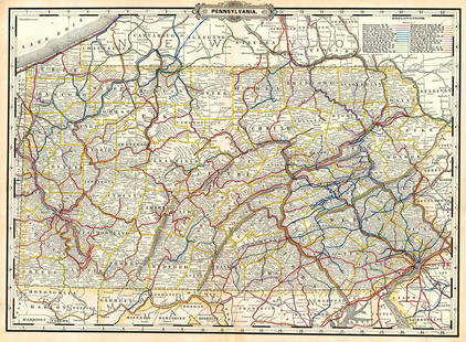
Sold2023Pennsylvania.Publication Date: 1889 Title: Pennsylvania. Cartographer: CRAM, GEORGE F. Publisher: GEO. F. CRAM Height: 16 Width: 22.30 Detailed map with railroad routes in colors. Letterpress on reverse. OrnamentaSee Sold Price
Sold2022PennsylvaniaTitle: Pennsylvania Date: 1876 Cartographer: GRAY, O.W. Publisher: O.W. GRAY & SON Description: Map showing exceptional detail such as hundreds of townships, topography, towns, railroads, etc. Height:See Sold Price
Sold2020New MexicoTitle: New Mexico Publication Date: 1885 Cartographer: CRAM, GEO. F. Publisher: CRAM, GEO. F. Brief Descriptions: Map showing counties, towns, townships, Indian reservations, railroads and topography.See Sold Price
Sold2023RR map of Arizona from scarce 1898 Cram’s Atlas.Large and dramatic double-page map of Arizona naming and showing all rail lines in the state. Every railroad line is named, numbered, and color-coded by a legend on the map. From the very scarce Cram�See Sold Price
Sold2023RR map of New Mexico from scarce 1898 Cram’s Atlas.Large and dramatic double-page map of New Mexico naming and showing all rail lines in the state. Every railroad line is named, numbered, and color-coded by a legend on the map. From the very scarce CrSee Sold Price
Sold2022(MIDWEST.) George Woolworth Colton. County & Township Railroad Map of the States of Wisconsin,(MIDWEST.) George Woolworth Colton. County & Township Railroad Map of the States of Wisconsin, Illinois, Missouri & Iowa. Large separately issued lithographed map within a decorative foliate border. 3See Sold Price
Sold2024Crams Railroad Map of New York-1881This is a Crams Railroad Map of New York dated 1881, Has a great fold-out full color map of the state of New York showing all railroad lines. Has almost no tears or frays. Booklet has 36 pages of counSee Sold Price
Sold2024Rand McNally County/Township/Railroad Map of Kansas-1911This is a Rand McNally County/Township/Railroad Map of Kansas dated 1911. Features a multi-paneled, fold-out map, attached inside the back cover, of all counties and railroads, in full color. AssociatSee Sold Price
Sold20221910 Railroad Map of Pennsylvania by Wall -- RailroadTitle: 1910 Railroad Map of Pennsylvania by Wall -- Railroad Map of Pennsylvania Published by the Department of Internal Affairs of Pennsylvania Cartographer: J S Wall / PA Dept. of Internal Affairs YSee Sold Price
Sold2023Track Chart Lehigh Valley Railroad Map 1950 Pennsylvania railroad track chart taco branch map 1957Pennsylvania railroad track chart taco branch map 1957 Pennsylvania railroad track chart map, northern division, 1955See Sold Price
Sold2023Crams 1909 Railroad Map of Illinois with Original CaseOne of the nicest rarities to come through our doors! This is an uber-rare Crams 1909 Railroad Map of Illinois. Started in 1867 as the firm of Blanchard and Cram, George F. Cram took full control of tSee Sold Price
Sold2017Cram's Map of Pennsylvania, 1883Map: Pennsylvania Maker: George F. Cram Date: 1883 21.75 x 14.5 in Please note that this lot has a confidential reserve. When you leave a bid in advance of the auction, submit your maximum. Jasper52 wSee Sold Price
Sold20231889 Cram Map of Pennsylvania -- PennsylvaniaTitle: 1889 Cram Map of Pennsylvania -- Pennsylvania Cartographer: G Cram Year / Place: 1889 c., Chicago Map Dimension (in.): 16.2 X 22.4 in. This is a very nice double-page map of Pennsylvania. PlentSee Sold Price
Sold2022The New Jersey Ocean Resorts on the Pennsylvania Railroad Map1908. 18 x 13 1/2 inches.See Sold Price
Jun 13Swann Auction Galleries(MAINE.) J.H. Colton; and C.C. Hall. Railroad & Township Map of the State of Maine with Portions$375
Jun 13Swann Auction Galleries(PHILADELPHIA -- ROXBOROUGH/MANAYUNK.) John Levering. Plan of the Township of Roxborough$500
Jun 27Rail & Road AuctionsFour Camden & Atlantic Railroad Annual Passes - 1868, 1876, 1879, and 1889$70
5 days LeftJasper52North America Sheet III West Canada With Parts of New York, Pennsylvania and Michigan$30
Jun 27Rail & Road Auctions54 Pieces of Pennsylvania Railroad Ephemera - Pocket Calendars, Maps, Aluminum Coins, etc$20(1 bid)
5 days LeftJasper52County and Township Map of the States of Massachusetts, Connecticut and Rhode Island$40
5 days LeftJasper521887 Mitchell Map of New Mexico and Arizona -- County and Township Map of Arizona and New Mexico$80
1 day LeftHolabird Western Americana CollectionsMeriden, Conn. Railroad Correspondence c1858-90 (75) [180592]$100
Jun 28Rail & Road AuctionsPennsylvania Railroad Lunkenheimer Three Chime Whistle - East Altoona Roundhouse & Nickel Plate$2,000
Jun 28Rail & Road AuctionsGroup of Four Pennsylvania Railroad Advertising Poster Prints and Calendar$40
2 days LeftHarris Toy and Train AuctionsAmerican Flyer Postwar S Gauge 21004 Pennsylvania Railroad Loco and Tender$20(1 bid)
Jun 28Rail & Road AuctionsGroup of Pennsylvania Railroad Silver - Butter Icer, Ash Tray, and Clipboard$40(1 bid)


![Meriden, Conn. Railroad Correspondence c1858-90 (75) [180592] (1 of 7)](https://p1.liveauctioneers.com/2699/331495/178786016_1_x.jpg?height=282&quality=70&version=1717094933)


