Sold2024Carey, pub. 1796 - Map of the State of MarylandThis fine map engraving is from one of the ealiest American atlases published in the states: Mathew Carey's General Atlas. The work was published in Philadelphia by Carey in 1796. It was an importantSee Sold Price
Sold2024Carey, pub. 1796 - Map of the Tennassee State formerly part of North Carolina (Tennessee)This fine map engraving is from one of the ealiest American atlases published in the states: Mathew Carey's General Atlas. The work was published in Philadelphia by Carey in 1796. It was an importantSee Sold Price
Sold2024Carey, pub. 1796 - A Chart of the West IndiesThis fine map engraving is from one of the ealiest American atlases published in the states: Mathew Carey's General Atlas. The work was published in Philadelphia by Carey in 1796. It was an importantSee Sold Price
Sold2016MATHEW CAREY (AMERICAN, 1760-1839) MAP OF DELAWAREMATHEW CAREY (AMERICAN, 1760-1839) MAP OF DELAWARE, hand-colored engraving on paper, titled "Delaware from the best Authorities", engraved by William Barker, published Philadelphia, 1795. Modern frameSee Sold Price
Sold20241814 Chili and Part of the Viceroyalty of La PlataPublished by Mathew Carey, Americans often depicted the southern tip of South America significantly narrower than reality. The coastal lands below Buenos Aires were even marked with a chilling title:See Sold Price
Sold20231795 Map of South American by Mathew Carey, Philadelphia16.5 x 21.5 inches, sight. Framed, 21.5 x 27 inches. Condition reports are not available for the items in this catalog. These are antique and vintage items, and will show signs of use and wear. We havSee Sold Price
Sold20211787 American Museum Magazine Daniel BooneThe October 1787 issue of "The American Museum or Repository of Ancient and Modern Fugitive Pieces…..", printed at Philadelphia by Mathew Carey, MDCCLXXXVII (1787). Title leaf, pages 315-415, ContenSee Sold Price
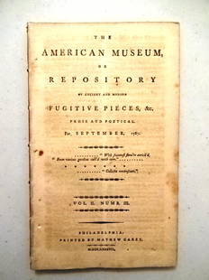
Sold20211787 Magazine First Printing of ConstitutionThe American Museum or Repository of Ancient and Modern Fugitive Pieces & c Prose and Poetical For September 1787. Published at Philadelphia by Mathew Carey MDCCLXXXVII. Vol. II Number III. COMPLETE iSee Sold Price
Sold20211787 Magazines Federalist Papers ConstitutionThe November and December 1787 issue of "The American Museum or Repositoryof Ancient and Modern Fugitive Pieces…..", Volume II Numbers V and VI, printed at Philadelphia by Mathew Carey, MDCCLXXXVII.See Sold Price
Sold2023MAP, Southern USA, CareySouthern United States. Mathew Carey, Georgia, from the Latest Authorities, from Carey's American Atlas of Guthrie's Geography, 1795 (published). Black & White. This scarce and significant map coversSee Sold Price
Sold2017Ferguson's Astronomy 1809 2nd US EditionJames Ferguson. Astronomy Explained Upon Sir Isaac Newton's Principles. Phila.: Mathew Carey, 1809. 8vo. 533 p. plus Index. 2nd American Edition, Revised, Corrected and Improved by Robert Patterson. FSee Sold Price
Sold2018Delaware.Title/Content of Map: Delaware. Date: 1814 Cartographer: CAREY, MATHEW/A. DOOLITTLE Size: 7.75X5.75 From the 4th edition of Carey's American Pocket Atlas. With text. Browned. Please note that this lotSee Sold Price
Sold2019United StatesTitle: United States Publication Date: c1805 Cartographer: CAREY, MATHEW ? Publisher: Size: 6.1Height - 7.1Width Anonymous pocket map, possibly from Carey's American Pocket atlas of 1805. Foxed and brSee Sold Price
Sold2024Carey, pub. 1814 - Map of the State of TennesseeThis engraved map is from Mathew Carey's General Atlas, improved and enlarged: being a collection of maps of the world and quarters, their principal empires, kingdoms, &c. The work was published in PhSee Sold Price
Sold2024Carey, pub. 1814 - Map of Mexico or New SpainThis engraved map is from Mathew Carey's General Atlas, improved and enlarged: being a collection of maps of the world and quarters, their principal empires, kingdoms, &c. The work was published in PhSee Sold Price
Sold2024Carey, pub. 1814 - A Chart of the WorldThis engraved map is from Mathew Carey's General Atlas, improved and enlarged: being a collection of maps of the world and quarters, their principal empires, kingdoms, &c. The work was published in PhSee Sold Price
Sold2024Carey, pub. 1814 - Map of Italy & SardiniaThis engraved map is from Mathew Carey's General Atlas, improved and enlarged: being a collection of maps of the world and quarters, their principal empires, kingdoms, &c. The work was published in PhSee Sold Price
Sold20231795 Carey's Am Ed of Guthries Impr Geography1795 Matthew Carey "Carey's American Edition of Guthrie's Geography Improved", 1st edition of the 1st American printed atlas, 43 of 44 maps remaining, incl Doolittle's Vermont, Virginia, the CarolinasSee Sold Price
Sold2023Rare map of Upper Territories by Mathew Carey, 1814Early and rare map of the old Northwest Territory. In this map the area of Michigan has yet to be understood. The extents of Saginaw Bay and Green Bay are also more or less guessed at. The map reflectSee Sold Price
Sold2022Very scarce 1814 Map of Virginia, Mathew CareyMathew Carey's map of Virginia, one of the best large format maps of the state to appear in a Commercial Atlas. From an extremely scarce 1816 edition of Carey’s General Atlas (the same map as inSee Sold Price
Sold2023Mathew Carey, State of Pennsylvania, EngravingMathew Carey, State of Pennsylvania, Engraving. Date: 1795Framed in good vintage condition, with signs of yellowing and marks due to age. First atlas of America printed in America. First edition. ThesSee Sold Price
Sold2020CAREY, MATHEW. Vermont.CAREY, MATHEW. Vermont. Double-page map of Vermont engraved by Amos Doolittle. 21¾x17 inches sheet size, wide margins; original hand-color in outline; small tears in the area of center fold reinfSee Sold Price
Sold2022Scarce 1816 map of Ireland from Mathew Carey atlasLovely and scarce map of Ireland from the very scarce 1816 edition of Mathew Carey’s General Atlas. Clearly delineates the four provinces of the country. Table in upper left identifies countiesSee Sold Price
Sold20231801 Mathew Carey (1760-1839) Antique BibleContinental, 19th century. A large bible dating to 1801. Well intact for sage, though there is loss and wear throughout. It was the first Roman Catholic version and only the second English-language trSee Sold Price
Jun 06Freeman's | HindmanCOOPER, James Fenimore (1789-1851). The Prairie. Philadelphia: Carey, Lea & Carey, 1827.$150
6 days LeftJasper521822 MAP of SOUTH AMERICA GEOGRAPHICAL STATISTICAL HISTORICAL antique 17.5x 22"$75
6 days LeftJasper521822 MAP of LEEWARD ISLANDS GEOGRAPHICAL STATISTICAL HISTORICAL antique 17.5x22"$120
1 hr LeftUniversity Archives"The American Museum": Three Signed Volumes, Includes First Serial Printing of Constitution, Owned b$850(3 bids)
Jun 02Carlsen Gallery, Inc.CARL BODMER NATIVE AMERICAN AQUATINT ENGRAVING "ABDIH - HIDDISCH" PUB. BY ACKERMAN, WITH BODMER$500
May 31Freeman's | Hindman[CIVIL WAR]. [BRADY, Mathew, (1822-1896), photographer]. Stereoview of General George Armstrong$200
May 31Freeman's | Hindman[CIVIL WAR]. BRADY, Mathew (1822-1896), photographer. Gen'l. Robt. E. Lee and Staff. Washington, DC,$1,500
May 31Freeman's | Hindman[CIVIL WAR]. BRADY, Mathew (1822-1896), photographer. Large format photograph of Ulysses S. Grant as$400
May 31Freeman's | Hindman[SHERMAN, William T. (1820-1891)]. [BRADY, Mathew (1822-1896), photographer]. Sherman and his$1,000
May 31Freeman's | Hindman[LINCOLN, Abraham (1809-1865)]. BRADY, Mathew (1822-1896), artist. "Inkwell pose" CDV of Lincoln.$250
May 31Freeman's | Hindman[CIVIL WAR]. A group of 3 CDVs of Union General Nathaniel P. Banks, his staff, and family.$200
May 31Freeman's | Hindman[CIVIL WAR]. Photographer unknown. Fortifications at City Point, Virginia. 1861-1865.$150


![Martha Washington's Slave [Matthew Brady] (1 of 2)](https://p1.liveauctioneers.com/7226/325455/175169164_1_x.jpg?height=282&quality=70&version=1712370394)

![[CIVIL WAR]. [BRADY, Mathew, (1822-1896), photographer]. Stereoview of General George Armstrong (1 of 2)](https://p1.liveauctioneers.com/197/329785/177758271_1_x.jpg?height=282&quality=70&version=1715716770)
![[CIVIL WAR]. BRADY, Mathew (1822-1896), photographer. Gen'l. Robt. E. Lee and Staff. Washington, DC, (1 of 5)](https://p1.liveauctioneers.com/197/329785/177758240_1_x.jpg?height=282&quality=70&version=1715625218)
![[CIVIL WAR]. BRADY, Mathew (1822-1896), photographer. Large format photograph of Ulysses S. Grant as (1 of 2)](https://p1.liveauctioneers.com/197/329785/177758264_1_x.jpg?height=282&quality=70&version=1715625218)
![[SHERMAN, William T. (1820-1891)]. [BRADY, Mathew (1822-1896), photographer]. Sherman and his (1 of 2)](https://p1.liveauctioneers.com/197/329785/177758265_1_x.jpg?height=282&quality=70&version=1715625218)
![[LINCOLN, Abraham (1809-1865)]. BRADY, Mathew (1822-1896), artist. "Inkwell pose" CDV of Lincoln. (1 of 2)](https://p1.liveauctioneers.com/197/329785/177758532_1_x.jpg?height=282&quality=70&version=1715625218)


![[CIVIL WAR] Custer CDV as Brig. General (1 of 3)](https://p1.liveauctioneers.com/7226/325455/175168966_1_x.jpg?height=282&quality=70&version=1712370394)
![[BOOKS] CIVIL WAR. LOT OF 6 VOLUMES SOLD TOGETHER (1 of 1)](https://p1.liveauctioneers.com/8124/329546/177689810_1_x.jpg?height=282&quality=70&version=1715469494)
![[BUTTRE, J. C. (1821-1893), engraver]. Abraham Lincoln. [Ne... (1 of 1)](https://p1.liveauctioneers.com/928/328184/176813626_1_x.jpg?height=282&quality=70&version=1714496988)
![[CIVIL WAR]. A group of 3 CDVs of Union General Nathaniel P. Banks, his staff, and family. (1 of 2)](https://p1.liveauctioneers.com/197/329785/177758294_1_x.jpg?height=282&quality=70&version=1715625218)

![[CIVIL WAR]. Photographer unknown. Fortifications at City Point, Virginia. 1861-1865. (1 of 2)](https://p1.liveauctioneers.com/197/329785/177758331_1_x.jpg?height=282&quality=70&version=1715625218)