Sold2021Original Vintage 1940s British Commonwealth Map PosterAnonymous - Great BritainThe British Commonwealth of Nations (Map)Offset ca. 194224.4 x 38.5 in. (62 x 98 cm)Printer: no informationCondition Details: (A-) was folded, on linen, tiny edge tears, minorSee Sold Price
Sold2016World Wide Stamp Collection, WWII, and OthersWorld Wide Stamp Collection, Includes several albums of British Commonwealth, colonies and possessions with emphasis on North Borneo, Sarawak, and Labuan, British Polynesia, Norfolk and Pitcairn IslanSee Sold Price
Sold2022Royal Wedding: Prince Charles, Lady Diana: First Day Cover Collection w/ One-Crown Coin-The Royal Wedding: England’s Prince Charles to Lady Diana Spencer First Day Cover Collection: An international collection of official first-day covers issued by British Commonwealth Nations andSee Sold Price
Sold2022A-Z world accumulation in 102s (100s), includes some British Commonwealth, Africian Nation, Asia,A-Z world accumulation in 102s (100s), includes some British Commonwealth, Africian Nation, Asia, will catlogue over 3700+, minor duplication, otherwise appears f-vfSee Sold Price
Sold2023WEST INDIES FLAGS. Saint Christopher-Nevis-Anguilla 1968 old vintage printThe British Commonwealth of Nations Saint Christopher-Nevis-Anguilla' by HMSO (1968). Vintage book plate, 8.0 x 12.0cm, 3.25 x 4.75 inches Additional Information: CAPTION PRINTED BELOW PICTURE: 'The BSee Sold Price
Sold2024SCOTTS STANDARD POSTAGE STAMP CATALOG AND MAGAZINESA vintage 107th edition of the Scotts Standard Postage Stamp Catalog, published in 1951. This volume, focusing on The Americas and the British Commonwealth of Nations, is a valuable resource for stampSee Sold Price
Sold2022BAHAMAS FLAGS. National Flag 1979 old vintage print pictureCAPTION PRINTED BELOW PICTURE: 'The British Commonwealth of Nations Bahamas; National Flag' DATE PRINTED: 1979 IMAGE SIZE: Approx 10.5 x 12.5cm, 4.25 x 5 inches (Small) TYPE: Vintage book plate CONDITSee Sold Price
Sold2021Wilkes, John 1797 Map. British Colonies in N. AmericaCopper Engraved Map Published 1796-1828 London for "Encyclopaedia Londinensis, or universal dictionary of arts, sciences and literature" by John Wilkes et al. Paper Size: 10.5 x 8.5 inch (27 x 22cm) VSee Sold Price
Sold20181766 British Colonies MapHigh Quality Color Printed Map on heavy paper circa 1970's A General Map of the Middle British Colonies, in America. containing Virginia, Maryland, the Delaware Counties, Pennsylvania and New Jersey.See Sold Price
Sold2022Guthrie, William 1805 Map. British Colonies in North America. CanadaCopper Engraved Map Published 1805, London for "A New Geographical, Historical and Commercial Grammar..." by William Guthrie. Folds as issued. Paper Size: 10.5 x 8 inch (27 x 21cm) Approx. Some toningSee Sold Price
Sold2022Collection of 9 British Commonwealth Silver CoinsCollection of nine coins from the British Commonwealth and British Colonies. Includes three Straits Settlement (Malaysia) one dollar coins - two 1907 and one 1920; two Bahamas two dollars coins - 1971See Sold Price
Sold2021Wooden box, coins various countries 1932-1986Large bundle. Official coins. 1932-1986. Netherlands, Great Britain, British Commonwealth, France, French Colonies, Belgium, Luxembourg, Greece, Austria, Spain, Russia, Scandinavia, Poland, Arab. StatSee Sold Price
Sold2021American colonies, 1755-1768, by R. Vaugondy. ParisTitle: American colonies, 1755-1768, by R. Vaugondy. Paris Date/Period: 1755-1768 Materials: Copperplate engraved Size: 24 x 18 1/2” A very interesting and important British American colonies mapSee Sold Price
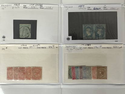
Sold2023British Commonwealth 1875-1904 #1/#25 Victoria British Colonies StampsBritish Commonwealth 1875-1904 #1/#25 Victoria British Colonies Stamps. A small, very nice selection of 16 Victoria Stamps. Consists of a rare imperf pair of Ceylon, #1 (wmk 6), #15 Bahamas (P 12 1/2)See Sold Price
Sold2023RARE WWII British Cloth Escape Maps European Theater 1943 Series #43 E/F.WWII British Cloth Escape Maps European Theater 1943 Series #43 E/F. This Silk map is in Excellent Condition as pictured. Side E has maps of Germany Protectorate, Slovakia, Poland, and Hungary while SSee Sold Price
Sold2023RARE WWII British Cloth Escape Maps European Theater 1943 Series #43 C/D.WWII British Cloth Escape Maps European Theater 1943 Series #43 C/D. This Silk map is in Excellent Condition as pictured. Side C has maps of Holland, Belgium, France and Germany while Side D has mapsSee Sold Price
Sold2023Set of Silver Proofs, Queen Elizabeth II, 2006Property of a Private Collector, Hilton Head Island, South Carolina Description: Set of Silver Proofs, Queen Elizabeth II, 2006, twelve 2006 silver proofs coins of nations of the British CommonweaSee Sold Price
Sold2023Laurie & Whittle Map of the British Colonies of North AmericaLAURIE, Robert (1755-1836), and WHITTLE, James (1757-1818). A New and Correct Map of the British Colonies in North America comprehending Eastern Canada...with the adjacent states of New England. EngraSee Sold Price
20241897 HISTORICAL GEOGRAPHY of BRITISH COLONIES - AFRICA w/ MAPS V.4 antiqueHISTORICAL GEOGRAPHY of BRITISH COLONIES by C.P.LUCAS Vol. IV SOUTH and EAST AFRICA Part I: Historical Part II: Geographical Illustrated w/ maps Size 6 by 9.5" Very good condition, minor wear Text inSee Sold Price
Sold2018LAURIE & WHITTLE BRITISH 18TH CENTURY MAP OF NORTHLAURIE & WHITTLE BRITISH 18TH CENTURY MAP OF NORTH AMERICA, hand-colored, title in cartouche to upper right corner "A NEW AND CORRECT MAP / OF THE / BRITISH COLONIES IN NORTH AMERICA / Comprehending /See Sold Price
Sold2022America.- Canada.- Laurie & Whittle (publishers) A NewAmerica.- Canada.- Laurie & Whittle (publishers) A New and Correct Map of the British Colonies in North America comprehending Eastern Canada...with the adjacent states of New England, showing from NewSee Sold Price
Sold2016A NEW MAP OF NORTH AMERICA FROM 1763 DISCOVERIESPrinted on laid paper with Irish 1763 Pro Patria watermark of Detailed map of the British Colonies in North America at the close of the French & Indian War. The claims of the Carolinas, Virginia and NSee Sold Price
Sold2023Map of the American Colonies from December, 1754This map is titled 'An Accurate Map of the English Colonies in North America bordering on the River Ohio', a scarce early map of the British Colonies in North America and one of the earliest maps to aSee Sold Price
Sold2021British Commonwealth stamp collection 4 loose albumBritish Commonwealth stamp collection 4 loose album pages countries include Nigeria, Morocco Colonies, Bermuda and Newfoundland. Good condition. We combine postage on multiple winning lots and can shiSee Sold Price
1 day LeftJasper52Antigua Falmouth English Harbour West Indies ADMIRALTY sea chart 1954 (1968) map$280
2 days LeftHunt and Peck Estate Services, Inc.1798 Bryan Edwards "The History Civil and Commercial of the british colonies in the west indies$50
1 day LeftJasper52General Map of the West Indies'. West sheet only. Bryan EDWARDS. Caribbean 1794$700
Jun 02Schilb Antiquarian Rare Books1897 History of British Empire England Scotland Canada James II MAPS India 6v$1
1818 AuctioneersBRITISH COMMONWEALTH GVI ERA FINE USED COLLECTION COUNTRIES A-C IN ALBUM Plymouth album with fin£60
May 16Zikorn Arts & History ObjectsWest Indies, Providence, Windward, Cuba 1834 British Admiralty Map$100(1 bid)
May 16Zikorn Arts & History ObjectsEntrance to Baltic Great & Little Belt 1852 British Admiralty Map$100
May 16Zikorn Arts & History ObjectsWest Indies, Cape Gracias to Belize 1843 British Admiralty Map$100
3 days LeftDoyen Auction"Afternoon in the Park" Figurative Watercolor Painting by Arthur David McCormick$2,000
7 days LeftFleischer's Auctions1755 Map Partie de l'Amerique Septentrionale, qui comprend Le Cours de L'Ohio...$150(2 bids)
May 15University ArchivesDeclaration of Independence, Very Early British Publ. in Gentleman's Magazine & Rare Map$1,000