Sold2021Glass World Globe PaperweightClear glass globe with textured and shaded world map continents. Measures 3 x 3.25 in. Desktop items, Paper & table accessories, home accents and decor, Art glass paperweight, globe paperweight, worldSee Sold Price
Sold2020Framed Antique Map Orbis Vetus, Robert De VaugondyItem/Description: Old print. Map of the world by Robert de Vaugondy from 1752. Orbis vetus in utraque continente : In both the old continent / world map / Vaugondy 1752. Material: Print framed under gSee Sold Price
Sold2022Signed by Cornelius Vanderbilt JrHeading: Author: Vanderbilt, Cornelius, Jr. Title: Man of the World: My Life on Five Continents Place Published: New York Publisher:Crown Publishers Date Published: 1959 Description: <See Sold Price
Sold2022ORTELIUS, ABRAHAM; and PHILILLPE GALLE. Set of 5 miniature maps of the world and continents.ORTELIUS, ABRAHAM; and PHILILLPE GALLE. Set of 5 miniature maps of the world and continents. Engravings with original hand-color. 4x5½ inches each sheet size, Latin text on verso; light finger soSee Sold Price
Sold2018World Map - Hand-Colored Engraving - England, 17thA Mapp or Generall Carte of the World Designed in two Plaine Hemisphers, by Monsieur Sanson Geographr to the French King and Rendered into English and Illustrated with Figures by Richard Blome By theSee Sold Price
Sold2022Anthony Finley’s 1833 map of The WorldLovely example of Finley's attractive The World on Mercator's Projection, from his 1833 New General Atlas. The world’s continents are shown in clear detail, with many rivers, cities, coastal feaSee Sold Price
Sold2021History of the World by Sir Walter Ralegh 1614 1stThe History of the World In Five Books by Sir Walter Ralegh (Raleigh). 1614. At London Printed for Walter Burre. 669 pp. Includes engraved title page; frontispiece and 8 maps with Chronological TableSee Sold Price
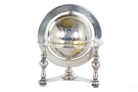
Sold2023Bulgari Sterling Silver & Vermeil Table Globe 805gA Bulgari Italian sterling silver table globe sculpture. Classical style design with spinning world map globe set within a round tri legged ring stand. Map continents finished in gold vermeil, and surSee Sold Price
Sold2022Curtis Jere, Pair of Earth Globe Mid Century WallCurtis Jere, pair of mid century modern wall art sculptures, globe form map of the world, featuring the continents with topography features. Approximately 19.9375W x 2.125H in.See Sold Price
Sold2023Assorted Maps on Europe & the Sub ContinentAssorted maps on Europe, Scandinavia, and the Sub Continent, including Celestial and World Maps, some old and hand colored, some modern and picture reproductions. Provenance: Phyllis Lucas Gallery, NYSee Sold Price
Sold2019Scarce 1850 plants distributionScarce 1850 map or chart by Joseph Meyer depicting plant geography. Shows the distribution of vegetation throughout the world. Features five illustrations showing the vegetation in various regions, inSee Sold Price
Sold2022Glass Lamp Globe, Imprinted Map of the WorldAmber glass lamp globe, with raised continents showing a map of the world. Handblown into a two piece mold. From Columbian Exposition 1893 Chicago World’s Fair; One likely hung in the electriciSee Sold Price
Sold2018Five Vintage World's Fair Souvenir Canes.Lot of Five Vintage World's Fair Souvenir Canes. Two 1933 Chicago and three 1939 New York. Including a New York 1939 World's Fair pull-out map cane. Largest measures 38-1/4"l. Condition: Good with weaSee Sold Price
Sold2022Buffon & Tardieu 1853 Map. Ancient World"Carte de l'Ancien Continent" Steel Engraved Map with outline hand color Published 1853-55, Paris for "Oeuvres Completes de Buffon" by the Comte de Buffon. Engraved by Ambroise Tardieu. Paper Size: 10See Sold Price
Sold2022Buffon & Tardieu 1853 Map. New World"Carte de Nouveau Continent" Steel Engraved Map with outline hand color Published 1853-55, Paris for "Oeuvres Completes de Buffon" by the Comte de Buffon. Engraved by Ambroise Tardieu. Paper Size: 10See Sold Price
Sold2022Ottoman, Turkish AtlasAn Ottoman, Turkish book dating back to the late Ottoman Empire (1927). It consists of 16 pages (20 by 24 cm) on which 18 maps are drawn. Maps that include the oceans and continents of the world.ThisSee Sold Price
Sold20245 U.S. fighter pilot East Asia escape cloth mapsHeading: (China - World War II escape map) Author: Title: Five US Army Air Force pilot silk escape maps of East Asia from World War II Place Published: Washington, D.C. Publisher:Army Map Service, U.See Sold Price
Sold20245 U.S. fighter pilot China-Japan escape cloth mapsHeading: (China - World War II escape map) Author: Title: Five US Army Air Force pilot silk escape maps of China and Japan from World War II Place Published: Washington, D.C. Publisher:Army Map ServiSee Sold Price
Sold2024Scarce h/c map of Plains states, Hardesty 1875A unique and pleasing map of five Plains states from the very scarce Jones & Hamilton version of H. Hardesty’s 1875 Historical Atlas of the World Illustrated. David Rumsey suggests this map andSee Sold Price
Sold2021Cram's Unrivaled Atlas of the World [131661]Maps of the continents, countries, colonies, plus all geographical and political divisions of the world. Also contains astronomical charts, diagrams, maps and descriptive matter. There are ancient claSee Sold Price
Sold2021Barlow 1807 Antique Map of Europe ContinentCopper Engraved Map Published 1807 by Brightly & Kinnersley, Bungay, England for "A General View of the World, Geographical, Historical and Philosophical" by The Rev. E. Blomfield. Maps Engraved by BaSee Sold Price
Sold2021Barlow 1807 Antique Map of Africa ContinentCopper Engraved Map Published 1807 by Brightly & Kinnersley, Bungay, England for "A General View of the World, Geographical, Historical and Philosophical" by The Rev. E. Blomfield. Maps Engraved by BaSee Sold Price
Sold2020Barlow 1807 Antique Map of Europe ContinentCopper Engraved Map Published 1807 by Brightly & Kinnersley, Bungay, England for "A General View of the World, Geographical, Historical and Philosophical" by The Rev. E. Blomfield. Maps Engraved by BaSee Sold Price
Sold2018Barlow 1807 Antique Map of Asia ContinentCopper Engraved Map Published 1807 by Brightly & Kinnersley, Bungay, England for "A General View of the World, Geographical, Historical and Philosophical" by The Rev. E. Blomfield. Maps Engraved by BaSee Sold Price
4 days LeftJasper521881 Vuillemin World Map with French Colonies Shown -- Planisphere: Indiquant les Colonies Francises$30
4 days LeftJasper521660 HISTORY of the WORLD by WALTER RALEIGH antique ILLUSTRATED w/ MAPS English$700
4 days LeftJasper521833 Woodbridge World Map -- Map of the World Adapted to Woodbridge's Geography$40
5 hrs LeftTrillium Antique Prints & Rare BooksSanson - Map of Canada or New France with the Great Lakes$75(1 bid)
5 hrs LeftTrillium Antique Prints & Rare BooksSanson - Map of Florida (encompassing most of Southeast North America)$130(2 bids)
5 hrs LeftTrillium Antique Prints & Rare BooksSanson - Map of the British Isles (Ireland, Scotland, England)$75
Jun 08Trillium Antique Prints & Rare BooksSanson - Map of California as an Island, Mexico (Audience de Guadalajara)$75
4 days LeftJasper521893 Civil War Map of Knoxville Area -- Topographical Map of the Approaches and Defences of$70


![Cram's Unrivaled Atlas of the World [131661]: Maps of the continents, countries, colonies, plus all geographical and political divisions of the world. Also contains astronomical charts, diagrams, maps and descriptive matter. There are ancient cla](https://p1.liveauctioneers.com/2699/202326/102449349_1_x.jpg?height=310&quality=70&version=1619652794)


![[MAP]. ORTELIUS, Abraham. Aevi Veteris, Typus Geographicus. 1601. (1 of 3)](https://p1.liveauctioneers.com/197/329395/177650532_1_x.jpg?height=282&quality=70&version=1715364962)


