Sold20245 U.S. fighter pilot East Asia escape cloth mapsHeading: (China - World War II escape map) Author: Title: Five US Army Air Force pilot silk escape maps of East Asia from World War II Place Published: Washington, D.C. Publisher:Army Map Service, U.See Sold Price
Sold20245 U.S. fighter pilot China-Japan escape cloth mapsHeading: (China - World War II escape map) Author: Title: Five US Army Air Force pilot silk escape maps of China and Japan from World War II Place Published: Washington, D.C. Publisher:Army Map ServiSee Sold Price
Sold2020WWII 1943 British East Anglia Air Force Map24 inch x 29.5 inch map of East Anglia produced by the British War Office and used by RAF and US Pilots. This one belonged to Brigadier General Jesse Auton, Cpommander of an 8th AAF Fighter Wing in WWSee Sold Price
Sold2020WWII 1942 British East Anglia Air Force Map24 inch x 29.5 inch map of East Anglia produced by the British War Office and used by RAF and US Pilots in 1942. This one belonged to Brigadier General Jesse Auton, Cpommander of an 8th AAF Fighter WiSee Sold Price
Sold2019Group of Three WWII U.S. Pilot Escape Silk Maps, "Group of Three WWII U.S. Pilot Escape Silk Maps, " Amsterdam, Hamburg, Berlin, Warsaw on reverse Vilnyus, and Minsk," H. - 24 in., W. - 30 in.; " Stalingrad on reverse Stepnoy," H. - 22 in., W. - 20 iSee Sold Price
Sold2023WWII 1943 USAAF Army Air Force Silk Pilot Escape Officers Cloth Map of ChinaWWII 1943 AAF Southeast China Cloth Silk Officers Map. This map was part of the Asiatic Series. The approximate size is 20 x 27 inches. Excellent condition with tape residue and a chemical type smellSee Sold Price
Sold2019Vietnam era pilot notes, guides, lineups, target mapsThis lot includes a large amount of notes, briefing guide material, photographs, slides, flight line ups, hand written day strike notes, Vietnam and south east Asia maps, pilots NOS mapstrap, and moreSee Sold Price
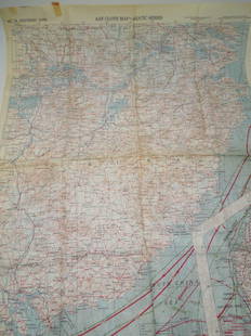
Sold2016Nagasaki pilot's escape map 1944Heading: (Japan) Author: Title: Nagasaki [&] Kagoshima Place Published: Washington, D.C. Publisher:Army Map Service Date Published: 1944 Description: Color maps, printed onSee Sold Price
Sold2022East Asian EmbroideryOrigin: East Asia Medium: Cloth and Thread Dimensions: Art: 29" X 46.5" Condition: Excellent Large embroidery of three images separated by a border even though the panels connect as well. The middle pSee Sold Price
Sold2019Butler, George 1874 Pair of Maps. Asia & East Indies"Asia" and "The Malay Archipelago" Lithograph Maps Published 1874, London for "The Public School Atlas of Modern Geography" by Rev. George Butler. Paper Size: Up to 13.75 x 10.5 inch (35 x 27cm) GoodSee Sold Price
Sold2022Cold War US Military Defense Aviation Pilot Maps LotCold War US Military Defense Aviation Pilot Maps Lot. Lot of 5 maps. You will receive the following maps: Global Navigation and Planning Chart GNC 26N, GNC 2, GNC 4, GNC 6 and GNC 8. Prepared and publSee Sold Price
Sold2022WW2 Hurricane Pilots collection of 5 signed A5 cards, each has career details printed on it.WW2 Hurricane Pilots collection of 5 signed A5 cards, each has career details printed on it. Autographed by Flight Lieutenant. T.E. Adams.No.28 Squadron South East Asia (Burma), Flight Lieutenant. F.WSee Sold Price
Sold2019The Times 1895 Pair of Maps. East Indies, Asia"Siam and the Malay Archipelago" and "Burma and the Malay Peninsula" Lithograph Maps Published 1895, London for "The Times Atlas" Paper Size: 16 x 10.5 inch (41 x 27cm) Good ConditionSee Sold Price
Sold2022Corea and Japan by John Thomson. East Asia. Korea 1817 old antique map chartTITLE/CONTENT OF MAP: 'Corea and Japan' DATE PRINTED: Published in 1817. Engraved on 16th August 1815; this date is marked on the map IMAGE SIZE: Approx 52.5 x 67.0cm, 20.75 x 26.5 inches (Large); PleSee Sold Price
Sold2022Corea and Japan by John Thomson. East Asia. Korea 1830 old antique map chartTITLE/CONTENT OF MAP: 'Corea and Japan' DATE PRINTED: 1830 IMAGE SIZE: Approx 52.0 x 66.5cm, 20.5 x 26.25 inches (Large); Please note that this is a folding map. TYPE: Antique early 19th century atlasSee Sold Price
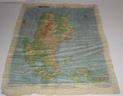
Sold20191945 US Army Escape Silk Map of Northern Sumatra/MalayTitle/Content of Map: 1945 US Army Escape Silk Map of Northern Sumatra/Malay Peninsula [verso] Central Sumatra -- [Escape Silk Map] C800 [verso] C920 Cloth Chart Date: 1945, Washington DC CartographerSee Sold Price
Sold2024TWO MAPS.England, 19th Century (circa 1800). Both by Emanuel Bowmen, hand colored lithographs. Great Britain 25.5"h. 28"w. Europe, Asia and the Middle East. 22.5"h. 28"w.See Sold Price
Sold2019Brookes, Richard 1807 Map of The East Indies, AsiaCopper Engraved Map Published 1807, London for "The General Gazetteer; Or, Compendious Geographical Dictionary" by Richard Brookes. Engraved by B. Baker. Folds as issued. Paper Size: 13 x 8.5 inch (33See Sold Price
Sold2017Johnston: Antique Map of the Chinese Empire, 1900Title/Content of Map: 'China' CHINESE EMPIRE. China East Asia Tibet Mongolia East Turkestan Korea Date Printed: 1900 Image Size: Approx 20.5 x 27.0cm, 8 x 10.5 inches (Medium) Type: Antique colour mapSee Sold Price
Sold2024East Asia, East Indies & Australasia sea & shipping routes 1917 old mapCAPTION PRINTED BELOW PICTURE: 'Map showing the Sea Routes' DATE PRINTED: 1917 IMAGE SIZE: Approx 29.0 x 26.0cm, 11.5 x 10.25 inches (Large); Please note that this is a folding map. TYPE: Antique coloSee Sold Price
Sold2024EAST ASIA. Eastern China Central Japan Korea. BARTHOLOMEW 1898 old antique mapTITLE/CONTENT OF MAP: 'Eastern China & Central Japan; Inset map of Tokio; Tozando' DATE PRINTED: 1898 IMAGE SIZE: Approx 43.5 x 32.5cm, 17 x 12.75 inches (Large); Please note that this is a folding maSee Sold Price
Sold2017WWII Pilot Escape Survival map handkerchief map1944 AAF Cloth Chart Philippine series silk double sided WWII Pilot Escape Survival handkerchief map. Foxing/stains. 20 inches x 25 inches.See Sold Price
Sold2024EAST ASIA Chinese Empire Japan China Mongolia Soongaria Tibet. COLLINS 1873 mapTITLE/CONTENT OF MAP: 'Chinese Empire & Japan' DATE PRINTED: 1873 IMAGE SIZE: Approx 23.5 x 31.0cm, 9.25 x 12.25 inches (Large); Please note that this is a folding map. TYPE: Antique colour map CONDITSee Sold Price
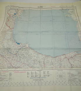
Sold2022Korean War USAAF Army Air 1952 Aviator Restricted Silk Escape Map of Baku & Rasht Pacific1952 Restricted USSR BAKU & Asia RASHT Silk Aviator Map. Korean War Era. Compiled, drawn and reproduced by the S.P.C. War Office. Approximate size is 24 x 25.5 inches. Excellent mint condition.See Sold Price
2 days LeftJasper521896 STANFORD'S COMPEDIUM of GEOGRAPHY & TRAVEL ASIA 2 VOLS. antique ILLUSTRATED$220
2 days LeftJasper521869 MALAY ARCHIPELAGO by A.WALLACE antique illustrated w /MAPS 1st US EDITION$480
May 30NY Elizabeth FIRST US EDITION OF 1869 MALAY ARCHIPELAGO BY A.WALLACE, ANTIQUE ILLUSTRATED WITH MAPS$50(1 bid)
May 30NY Elizabeth ANTIQUE MAP-ILLUSTRATED FLORAL ILLUSTRATION 1761 NEW DICTIONARY OF TRADE AND COMMERCE R. ROTH$50
May 26GOLDEN SUN AUCTIONS, Inc. (formerly Appraisal & Estate Sale Specialists, Inc.)(5) 1996-97 Kenner Star Wars Collector Series-MIB-NOS$40
6 days LeftBlackstone Valley Auctions & Estates LLCWWII Era U.S. Army 11th Airborne Patches & Wings.$150
Jun 08RbfineartsA Fine And Important Chinese Carved Wood Sculpture Depicting 6 Figures Kwan Yin Etc$160(3 bids)
7 days LeftLeonard Auction, a division of The Leonard CompanyVietnam War Era Military Uniform and Ephemera Assortment$150
May 22Concept Art Gallery2 Zane Grey Fishing Tales 1st Editions New Zealand and Fresh-Water$40(2 bids)


![Nagasaki pilot's escape map 1944: Heading: (Japan) Author: Title: Nagasaki [&] Kagoshima Place Published: Washington, D.C. Publisher:Army Map Service Date Published: 1944 Description: Color maps, printed on](https://p1.liveauctioneers.com/642/89389/45684047_1_x.jpg?height=310&quality=70&version=1464736315)


![1945 US Army Escape Silk Map of Northern Sumatra/Malay: Title/Content of Map: 1945 US Army Escape Silk Map of Northern Sumatra/Malay Peninsula [verso] Central Sumatra -- [Escape Silk Map] C800 [verso] C920 Cloth Chart Date: 1945, Washington DC Cartographer](https://p1.liveauctioneers.com/5584/134050/68048822_1_x.jpg?height=310&quality=70&version=1546996032)


![[SOUTH EAST ASIA] LOT OF 4 ALBUMEN PRINTS TOGETHER (1 of 6)](https://p1.liveauctioneers.com/8124/329546/177689865_1_x.jpg?height=282&quality=70&version=1715469494)


