Sold2024Blaeu Map of the Amazon Region, BrazilBLAEU, Willem Janszoon (1571-1638). Guiana Siue Amazonum Regio. Engraved map with original hand color. Amsterdam, c. 1640. 18 1/2" x 22 3/4" sheet.See Sold Price
Sold2017Blaeu Map of BrazilMaritima Brasiliae Universa. Joan Blaeu (1596-1673). Engraved map with original color in part. Amsterdam: Blaeu, 1647. 21 x 24 1/2 inches sheet, 32 1/2 x 36 inches framed. This separately issued and rSee Sold Price
Sold20221650 Blaeu Map of Brazil -- BrasiliaTitle: 1650 Blaeu Map of Brazil -- Brasilia Cartographer: J Blaeu Year / Place: 1650, Amsterdam Map Dimension (in.): 15.2 X 19.5 in. This is a magnificent large map of most of Brazil, Guiana and UruguSee Sold Price
Sold2017Blaeu: Antique Map of Brazil, 1634Map: Novus Brasiliae Typus Cartographer: Blaeu Place & Date: Amsterdam / 1634 (circa) Size: 19 1/2" x 15" Condition: b&w; cleaned; some minor spotting; centerfold reinforced Blaeu's superb, Hondius-deSee Sold Price
Sold2024A Ticuna bark and cloth maskA Ticuna bark and cloth mask20th century; Ticuna People, Amazon River region, Colombia/Brazil/PeruWith carved balsa wood face decorated with brown pigment surrounded by a bark cloth shroud with polychSee Sold Price
Sold2024A Pam'wa tak¸ ceremonial dance mask"A Pam'wa tak¸ ceremonial dance mask20th century Pam"'wa (Cubeo) Peoples; Amazon River Region Colombia/BrazilThe anthropomorphic dance mask or costume constructed of bark cloth with raffia fringe andSee Sold Price
Sold20231638 Blaeu Map of Western Pyreneese Region -- Navarra RegnumTitle: 1638 Blaeu Map of Western Pyreneese Region -- Navarra Regnum Cartographer: J Blaeu Year / Place: 1638 c., Amsterdam Map Dimension (in.): 16x19.8 in. This is a highly decorative double-page mapSee Sold Price
Sold20191883 1ed South AMERICA Peru Brazil Amazon Illustrated1883 1ed South AMERICA Peru Brazil Amazon Illustrated MAP Animals Far-Off Lands ‘Pictures of Travel in Far-off Lands’ is a late 19th-century geography handbook designed to provide basic informatioSee Sold Price
20191883 1ed South AMERICA Peru Brazil Amazon Illustrated1883 1ed South AMERICA Peru Brazil Amazon Illustrated MAP Animals Far-Off Lands ‘Pictures of Travel in Far-off Lands’ is a late 19th-century geography handbook designed to provide basic informatioSee Sold Price
Sold2024Group (8) South American baskets, Amazon regionGroup (8) South American baskets, Amazon region, 20th c., Venezuela and Brazil, each with pigment decoration, 15.5"dia (largest), 12"dia (smallest) Provenance: The Collection of Paul J. Smith: Arts AdSee Sold Price
Sold2024BLAEU 17TH C. MAP OF THE SARLAT REGION OF FRANCEHand-colored engraving with centerfold and text verso. Full description on dealers label. Dated to circa 1642. Matted. Dimensions: L 27" x W 22" Condition: Paper with light age toning. Offset from texSee Sold Price
Sold2017Guillaume Blaeu: Map of Russia, Estonia to Moscow, 1660Russiae Vulgo Moscovia dictae Pars Occidentalis. By: Guillaume Blaeu Date: c. 1660 Dimensions: 19.25 x 15 in. (49 x 38.5 cm) This is an attractive early 17th century map showing the region of Russia fSee Sold Price
Sold2020Willem Blaeu Map of Guinea ca. 1631Willem Janszoon Blaeu (1571-1638), "Guinea," Amsterdam, ca. 1631. A hand colored map of the Gulf of Guinea region of Africa, including what is now Guinea, Sierra Leone, Liberia, Cote d'Ivoire, Ghana,See Sold Price
Sold20221667 Blaeu Map of Orvieto, Italy -- Territorio diTitle: 1667 Blaeu Map of Orvieto, Italy -- Territorio di Orvieto Cartographer: Blaeu Family Year / Place: 1667 c., Amsterdam Map Dimension (in.): 15x19.4 in. This is a lovely map of Orvieto region, juSee Sold Price
Sold2022DOMINIO FIORENTINO & JOHANNES BLAEU 1646 MAPCopper engraving, depicting Florence and the Cities in the Region of Tuscany, from Willaem Janszoon Blaeu, Atlas Mayor, containing a title cartouche the right, incorporating a monarch, a knight, lionSee Sold Price
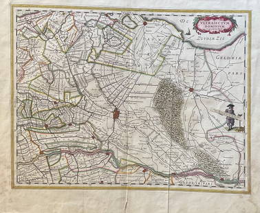
Sold2023The Netherlands Map. The region Around the city of Utrecht. 1660?s by W. BlaeuTitle: The Netherlands Map. The region Around the city of Utrecht. 1660?s by W. Blaeu Date/Period: 1660?s Materials: Hand colored copper plate engraved Size: 22 x 19 1/2'' Netherlands regional map cenSee Sold Price
Sold202417th century Brazil original map. "Prefecturae Paranburae Pars Borealis" map by Blaeu. Sheet size:17th century Brazil original map. "Prefecturae Paranburae Pars Borealis" map by Blaeu. Sheet size: 18.875 x 23.375in.See Sold Price
Sold2016Map of Milan region Italy 1640Heading: Author: Blaeu, Willem Title: Stato di Milano Place Published: Amsterdam Publisher: Date Published: c.1640 Description: Copper-engraved map, hand-colored in outline; colSee Sold Price
Sold2022Africa.- Blaeu (Willem Jansz.) Aethiopia Inferior velNO RESERVE Africa.- Blaeu (Willem Jansz.) Aethiopia Inferior vel Exterior, map of South Africa covering the region from Congo-Zanzibar to the Cape, decorative title cartouche of a animal skin held aloSee Sold Price
Sold20241816 Map of Brazil From Mathew Carey AtlasShows the territory of Brazil from the mouth of the Amazon to the Rio de la PlataSee Sold Price
Sold2022Antique Framed Engraved Map of Brazil"Office of Pernambuco Northern Region" (caption translation). This engraving of a map of Brazil includes an inset image showing a sugar plantation and enslaved people engaged in various tasks. In theSee Sold Price
Sold2020BLAEU, WILLEM. Persia Sive Sophorum Regnum.BLAEU, WILLEM. Persia Sive Sophorum Regnum. Hand-colored double-page engraved map of modern-day Afghanistan, Pakistan, Iraq, Iran, and the Persian Gulf region. 15½x21 inches sheet size, top and bSee Sold Price
Sold2024Willem Blaeu, Map of The AmericasAmsterdam, 1617. Together with "Early Maps" by Tony Campbell, Abbeville Press and "The United States in Old Maps and Prints, Eduard Van Ermen. 3 pieces Sight size: 16-1/2"h x 22"w Overall: 23-1/2"h xSee Sold Price
Sold2019Wilem J. Blaeu mapWilem J. Blaeu (Dutch 1571-1638)- Americae Nova Tabula- engraved map with hand-coloring, ca. 1633. 16 1/4 x 21 1/2''See Sold Price
6 days LeftJasper521764 Bellin Map of Brazil from the Sao Paulo Area to Salvador -- Suite du Bresil Depuis la Baye de$30
Jun 07Freeman's | Hindman[MAP]. TODESCHI, Pietro. [Nova et Acurata Totius Americae Tabula auct. G.I. Blaeu] America quarta$5,000
Jun 12Dan Morphy AuctionsPHELPS’S TRAVELERS GUIDE THROUGH THE UNITED STATES; CONTAINING UPWARDS OF SEVEN HUNDRED$1,000
6 days LeftJasper521788 Bowen Map of Ottoman Empire and Mediterranean Region -- A Correct Map of the Ottoman Empire,$140
Jun 07Freeman's | HindmanHOMANN, Johann Baptist. Amplissimae Regionis Mississipi Seu Provinciae Ludovicianae. Nuremburg, [ca$400
223 Lots AwayJasper52l'Arménie, la Géorgie et la Daghistan Caucasus. SANTINI/RIZZI-ZANNONI 1784 map$120
Jun 07Freeman's | Hindman[MAP]. ORTELIUS, Abraham. Peregrinationis Divi Pauli Typus Corographicus. 1592.$150
May 23Forum AuctionsIndia.- Laurie & Whittle (publishers) A New Map of the Jaghir Lands, on the Coast of Coromandel, The£75
7 days LeftJasper52India North Western Frontier Kashmir Pamir region Afghanistan. STANFORD 1896 map$280
7 days LeftThomaston Place Auction GalleriesHAND COLORED MAP OF PERU & COUNTRY OF THE AMAZONS, 1747, BY EMANUEL BOWEN, FRAMED$250
Jun 07Freeman's | HindmanMURCHISON, Roderick Impey, Sir. The Silurian System. 1839. COMPLETE WITH VERY RARE HAND-COLORED$1,500
6 days LeftJasper521879 Powell Map of Utah -- Map of Utah Territory Representing the Extent of the Irrigable, Timber$120
257 Lots AwayJasper52Central Europe. Germany Poland Czechoslovakia Carpathian Ruthenia TIMES 1922 map$30


![[MAP]. TODESCHI, Pietro. [Nova et Acurata Totius Americae Tabula auct. G.I. Blaeu] America quarta (1 of 1)](https://p1.liveauctioneers.com/197/329395/177650542_1_x.jpg?height=282&quality=70&version=1715364962)


![[MAP]. ORTELIUS, Abraham. Peregrinationis Divi Pauli Typus Corographicus. 1592. (1 of 2)](https://p1.liveauctioneers.com/197/329395/177650535_1_x.jpg?height=282&quality=70&version=1715364962)


