Sold2017Kaart Van Het Onderkoningschap Van Peru 1765 MapKaart Van Het Onderkoningschap Van Peru 1765 Map. Title/content of Map: 'kaart Van Het Onderkoningschap Van Peru, Zig Uitstrekkende Over Chili, Paraguay, En Andere Spaansche Landen: Als Ook Van BrazilSee Sold Price
Sold2019Attributed to Isaak Tirion (1705-1765), "Kaart Van HetAttributed to Isaak Tirion (1705-1765), "Kaart Van Het Eiland Terre-Nueve, Van Nieuw Schotland/Kanada," c. 1740, engraving on laid paper, H. - 9 in., W. - 13.5 in.See Sold Price
Sold2017An antique map of Poland by Izaak Tirion, circa 1740An antique map of Poland by Izaak Tirion, circa 1740 Title: [Old Antique map of Poland / Lithuania] Nieuwe Kaart van het Koninkryk Poolen. Author: Tirion, Izaak , Amsterdam, c. 1740. DescriSee Sold Price
Sold2023Antique Map of The Holy Land, Dated 1792"Generaale Kaart Van Het Beloofde Land" colored map of The Holy Land, covering present-day Israel and Palestine, bordered by Egypt and Syria. Dated 1792, unframed. [22 x 26 inches]. Dry, losses, creasSee Sold Price
Sold2017Tirion: Antique Map of the Western Hemisphere, 1754Map: Nieuwe Kaart van het Westelykste Deel der Wereeld Cartographer: Isaac Tirion Place & Date: Amsterdam / 1754 Size: 14 1/4" x 13 1/4" Condition: wash color; light overall age toning; backed to reinSee Sold Price
Sold2018Bachiene/Schalekamp: Cuba, 1785Reserve Reduced! Title of Map: Kaart van het Eiland Cuba. Cartographer: Bachiene / Schalekamp Place/Date: Amsterdam / 1785 Size: 12 1/4" x 8 1/2" Condition: Outline color; overall age toning; some staSee Sold Price
Sold20191766 Beautiful Handcolored Map Cayenne1766 hand colored engraved map and plan “Land-Kaart van het Eiland en de Volkplanting van Cayenne aus de Kust van Zuid-Amerika”, by Isaak Tirion,. Fine, close right margin. Measures 18 x 16”, foSee Sold Price
Sold2017Bellin: Antique Map of The Mexican Heartland, 1754Map: Carte du Mexique/Kaart van het Mexico Cartographer: Bellin / van der Schley Place & Date: Amsterdam / 1754/1771 Size: 12" x 8 1/2" Condition: wash color; a beautifully colored and preserved exempSee Sold Price
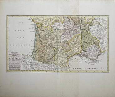
Sold2019Isaak Tirion (1705-1765, Amsterdam), "Nieuwe Kaart vanIsaak Tirion (1705-1765, Amsterdam), "Nieuwe Kaart van het Zuidelykste Gedeltevan Frankryk," 1757, hand colored, H. - 16 7/8 in., W. - 20 7/8 in.See Sold Price
Sold2020Map of the Dutch East Indies, 1726Heading: Author: Valentijn, François Title: Kaart van de Zuyd-Ooster Eylanden van Banda Place Published: Dordrecht Publisher:Joannes van Braam & Gerard onder de Linden Date Published: 1726See Sold Price
Sold2022(DUTCH EAST INDIES.) Adrian J. Bogaerts. Algemeene Land-en Zee-Kaart van de Nederlandsche(DUTCH EAST INDIES.) Adrian J. Bogaerts. Algemeene Land-en Zee-Kaart van de Nederlandsche Overzeesche Bezittingen, met het Koningrijk der Nederlanden in Europa. Large engraved six-panel chart of MalaySee Sold Price
Sold2019Map of England & Wales 1760Heading: (Maps) Author: Tirion, Isaac Title: Nieuwe Kaart van 't Zuider Gedeelte van Groot Britannie behelzende Het Koningryk Engeland… Place Published: Amsterdam Publisher: Date Published: 1See Sold Price
Sold2015Painting, Franz (Francois) van SeverdonckFranz (François) van Severdonck (Belgian, 1809-1889), Pasture Scene with Horse, Ram and Sheep, oil on panel, signed lower right amd verso, sight: 7"h x 10"w, overall (with frame): 15.25"h x 18.5"wSee Sold Price
Sold20201684 Pas kaart Van de Caribes Tusschen I. Barbados en IThis is an authentic antique map of the Lesser Antilles by Johannes Van Keulen. The map was published in Amsterdam in the year 1684. This is an impressive hand colored example of Van Keulen’s nSee Sold Price
Sold2021FRANCOIS VAN SEVERDONCK (Belgian, 1809-1889)Pair of Landscapes with Sheep and Fowl Oil on panel Signed and dated 1871 Size: 7 x 9.5 in. (each) with Odon Wagner Gallery, TorontoSee Sold Price
Sold2021Francois van Severdonck (Belgian, 1809-1889)Francois van Severdonck (Belgian, 1809-1889) "Sheep and Lamb Near a Duck Pond", 1868 oil on wood panel signed and dated lower center, further inscribed en verso. Framed. 6-3/4" x 9-1/4", framed 12" xSee Sold Price
Sold20221687 Keulen Map of North and South America's Mostly Atlantic Coastal Areas -- Pas Kaart van WestTitle: 1687 Keulen Map of North and South America's Mostly Atlantic Coastal Areas -- Pas Kaart van West Indien Behelsende soo Deszelffs Vaste Kusten als d'Onder Behoorende Eylanden aan de Noord OceaanSee Sold Price
Sold2022KEULEN, JOHANNES VAN Pas kaart Van de Boght van Florida Met de Canaal Tusschen Florida en Cuba Door.KEULEN, JOHANNES VAN Pas kaart Van de Boght van Florida Met de Canaal Tusschen Florida en Cuba Door. Amsterdam: Gerard Van Keulen, [1734]. Fifth state. Engraved map, hand colored, framed; sheet measurSee Sold Price
Sold2020KEULEN, JOHANNES van. Pas Kaart van de Golff vanKEULEN, JOHANNES van. Pas Kaart van de Golff van Mexico. Double-page engraved chart of the Gulf of Mexico. 21¼x24¼ inches sheet size, ample margins; light staining, small edge chips or tearsSee Sold Price
Sold20231755 Tirion Map of Eastern North America -- Nieuwe Kaart van de Grootbrittannische Volkplantingen inTitle: 1755 Tirion Map of Eastern North America -- Nieuwe Kaart van de Grootbrittannische Volkplantingen in Noord America Cartographer: I Tirion Year / Place: 1755, Amsterdam Map Dimension (in.): 14.3See Sold Price
Sold2023Van Keulen map of the Chesapeake Bay AreaVAN KEULEN, Johannes (1654-1715). Pas Kaart van de Zee Kuysten van Virginia. Engraved map with original hand color in part. Amsterdam, circa 1695. 20 3/4” x 24” sheet, 25” x 28 1/2&rSee Sold Price
Sold2015Dapper's Asia 1672Heading: Author: Dapper, Olfert Title: Asia, of Naukeurige beschryving van het rijk des Grooten Mogols, en een groot gedeelte van Indiën: Behelsende de landschappen van Kandahar, Kabul, Multan, HaïSee Sold Price
Sold2016Attributed To: Lambert Sustris, Dutch (1515-1568) 16thAttributed To: Lambert Sustris, Dutch (1515-1568) 16th Century Oil on Canvas "Voor de Terugkeer Van Het Kind" Unsigned. Depicts a classical scene with child returning home to the family. Some paint loSee Sold Price
Sold2020Kaarte van de Golf van Mexico en het Zuyd-America waarBy: Daniel de la FeuilleDate: 1747 (Published) AmsterdamDimensions: 19.5 x 22.5 inches (50 cm x 57 cm)This is an extremely rare and highly unusual map by the cartographer Daniel de la Feuille, and engSee Sold Price
1 day LeftCarlo Bonte AuctionsConstant Permeke (1886-1952), rural landscape in autumn, 1913, oil on canvas 110 x 135 cm. (43.3 x€12,000
3 days LeftJasper52The gibeonites deceive Joshua - Dutch Bible Scenes - Antique Engraving (c.1720)$65
2 days LeftJasper521610 CHARLES V BIOGRAPHY illustrated LATIN AMERICA Mexico Peru CONQUESTS ANTIQUE$800
3 days LeftDane Fine Art AuctionsRembrandt Harmensz van Rijn (After) by Pierre Francois Basan The Spanish Gypsy Preciosa$850
3 days LeftNY Elizabeth 1757 HISTORY PANTHEUM MYTHICUM - ANTIQUE ROTTERDAM ARMORIAL VELLUM WITH ILLUSTRATIONS$50(1 bid)
3 days LeftNY Elizabeth 1777 HISTORY ILLUSTRATION OF AN ANCIENT DORDRECHT ARMORED SHELL BY PANTHEUM MYTHICUM$50
2 days LeftJasper521732 NUMISMATIC HISTORY of NETHERLANDS 3 FOLIO VOLUMES antique ILLUSTRATED COINS$550


![An antique map of Poland by Izaak Tirion, circa 1740: An antique map of Poland by Izaak Tirion, circa 1740 Title: [Old Antique map of Poland / Lithuania] Nieuwe Kaart van het Koninkryk Poolen. Author: Tirion, Izaak , Amsterdam, c. 1740. Descri](https://p1.liveauctioneers.com/6018/113868/58519818_1_x.jpg?height=310&quality=70&version=1513369839)
![Antique Map of The Holy Land, Dated 1792: "Generaale Kaart Van Het Beloofde Land" colored map of The Holy Land, covering present-day Israel and Palestine, bordered by Egypt and Syria. Dated 1792, unframed. [22 x 26 inches]. Dry, losses, creas](https://p1.liveauctioneers.com/1221/303742/163342134_1_x.jpg?height=310&quality=70&version=1697564518)


![KEULEN, JOHANNES VAN Pas kaart Van de Boght van Florida Met de Canaal Tusschen Florida en Cuba Door.: KEULEN, JOHANNES VAN Pas kaart Van de Boght van Florida Met de Canaal Tusschen Florida en Cuba Door. Amsterdam: Gerard Van Keulen, [1734]. Fifth state. Engraved map, hand colored, framed; sheet measur](https://p1.liveauctioneers.com/292/250642/130213613_1_x.jpg?height=310&quality=70&version=1654271664)


