Sold2018British publication of Lavoisne's historical atlas 1822Heading: Author: Lavoisne, C.V. Title: Lavoisne's Complete Genealogical, Historical, Chronological, and Geographical Atlas; Being a General Guide to History, Both Ancient and Modern... Place PublisheSee Sold Price
Sold2018[LAVOISNE, M.]. A Complete Genealogical, Historical,LAVOISNE, C. V. A Complete Genealogical, Historical, Chronological, and Geographical Atlas; Being a General Guide to History. Philadelphia: M. Carey and Son, 1820. 4to (444 x 300 mm). 71 maps, tables,See Sold Price
Sold2019Maps from Lavoisne's Atlas, 1820Heading: Author: Lavoisne, C.V. Title: 23 maps from "A Complete Genealogical, Historical, Chronological, and Geographical Atlas," plus the remainder of the disbound atlas with the genealogical chartsSee Sold Price
Sold2015A Complete Genealogical, Historical,Chronological, and Geographical Atlas; Being a General Guide to History, Both Ancient and Modern, etc. by M. Lavoisne, Philadelphia: M. Carey and Son, 1820, second American edition, carefully revisedSee Sold Price
Sold2024[MAPS] Laviosne's Complete Genealogical, Historical, Chronological, and Geographical AtlasJohn Satchell Laviosne's Complete Genealogical, Historical, Chronological, and Geographical Atlas Upon the Plan of le Sage; Exhibiting the Origin, Descent, and Marriages, of all the Royal Families, frSee Sold Price
Sold20211821 map of Scotland by M. CareyDetailed, copperplate engraved map of Scotland. With vivid and original hand coloring. From A Complete Genealogical, Historical, Chronological, and Geographical Atlas; Being a General Guide to AncientSee Sold Price
Sold2016Geographical & Statistical Map of England for theGeographical and Statistical Map of England for the Elucidation of Lavoisne's Genealogical Historical Chronological and Geographical Atlas, 1828, printed by J. Barfield, hand-colored copper engraved mSee Sold Price
Sold20231847 Mitchell atlas complete w/all maps in excellent conditionVery scarce 1847 New Universal Atlas published by S. Augustus Mitchell, complete with all maps and in sound, clean condition. Contains 72 lithographed maps as called-for, all with original, full hand-See Sold Price
Sold2017Map of Europe: Drawn from the Best Authorities, 1820Map of Europe: Drawn from the Best Authorities. Thom. H. Palmer, for M. Carey & Son, Young & Delleker. 1820. For the illustration of Lavoisne's genealogical, historical, chronological & geographical aSee Sold Price
Sold2017Carey: Geographical & Statistical Map of Europe, 1822Geographical and Statistical Map of Europe. M. Carey, Young & Delleker 1822. Restriking of map, Europe: drawn from the best authorities for the illustration of Lavoisne's genealogical, historical, chrSee Sold Price
Sold2024Luxuriously bound 1873 Universal Historical AtlasSheahan, James W. (editor). The Universal Historical Atlas, Genealogical, Chronological, and Geographical ... being a Comprehensive History of the World from the latest Recognized Authorities. New YorSee Sold Price
Sold2022SOCIETY FOR THE DIFFUSION OF USEFUL KNOWLEDGE The Complete Atlas of Modern, Classical and Celest...SOCIETY FOR THE DIFFUSION OF USEFUL KNOWLEDGE The Complete Atlas of Modern, Classical and Celestial Maps, together with Plans of the Principal Cities of the World, bound in 2 vol., 226 hand-colouredSee Sold Price
Sold20242 VOLUMES, FOLIO, THE COMPLETE ATLAS OF MODERN CLASSICAL, AND CELESTIAL MAPS, 1873The Complete Atlas of Modern Classical and Celestial Maps, in two Volumes. London: Edward Stanford. 1873. Folio. For display and reference in your library. Condition as shown. Group: 17.75" x 14.5" xSee Sold Price
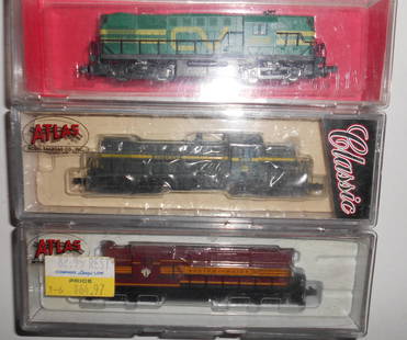
Sold2023N Scale 3 Atlas Diesels: CV, Rut, B&MN scale - 3 "Classic" Atlas diesel locomotives: (1) Central Vermont RS-11 #3609 (2) Rutland RS-1 #401, Boston & Maine GP-7 #1557. None have been tested but all look Good. Assume they are all DC.See Sold Price
Sold2019COOKE (G A) Modern and Authentic System of UniversalCOOKE (G A) Modern and Authentic System of Universal Geography...forming a Complete Collection of Voyages and Travels... Complete Atlas, no date, c.1800, 4to, 24 folding maps, plates with some typicalSee Sold Price
Sold2016Atlas of New York and Vicinity by F.W. Beers 1867Atlas of New York and Vicinity by F.W. Beers 1867; gilt letter are worn; last page (which is blank) is ripped, the atlas is complete, has 44 pages with many fold out maps including Sing Sing, DutchessSee Sold Price
Sold20201893 Flags of the WorldTitle: 1893 Flags of the World Author: Fisk Medium: Ink on Paper Dimensions: 14"X12" Description: Flags of the World dated 1893. Engraved by E.F. Fisk for the Columbia World Atlas. Rather complete priSee Sold Price
Sold2017Lavoisne: Antique Map of China, 18211821 Lavoisne Map of China. Very clean map from the third edition of Lavoisne’s Atlas. Lovely and vivid original hand-coloring. Full title of map: “China and the Tributary Kingdom of Corea for theSee Sold Price
Sold2023Russell & Barclay C1840 Hand Col Astronomy Print. Armillary SphereHand Colored Copper Plate Published 1823-40, by Fisher & Son, "A Complete Atlas of the World" by John Russell et al. A Very Rare Work which is compiled from the same plates used in different editionsSee Sold Price
Sold2023Russell & Barclay 1840 Hand Col Map. Mexico with Southern USAHand Colored Copper Engraved Map Published 1823-40, by Fisher & Son, "A Complete Atlas of the World" by John Russell et al. A Very Rare Work which is compiled from the same plates used in different edSee Sold Price
Sold2023Russell & Barclay C1825 Antique Map. North America. USA CanadaCopper Engraved Map Published C1825., by Fisher & Son, "A Complete Atlas of the World" by John Russell et al. The companion Atlas to "A Complete and Universal English Dictionary" by James Barclay. PapSee Sold Price
Sold2023Russell & Barclay 1832 Hand Col Map. Canada. British Dominions in North AmericaHand Colored Steel Engraved Map Published 1823-40, by Fisher & Son, "A Complete Atlas of the World" by John Russell et al. A Very Rare Work which is compiled from the same plates used in different ediSee Sold Price
Sold2023Russell & Barclay 1814 Antique Map. States of America. USACopper Engraved Map Published C1825., by Fisher & Son, "A Complete Atlas of the World" by John Russell et al. The companion Atlas to "A Complete and Universal English Dictionary" by James Barclay. PapSee Sold Price
Sold2023Russell & Barclay 1839 Hand Col Map. North AmericaHand Colored Copper Engraved Map Published 1823-40, by Fisher & Son, "A Complete Atlas of the World" by John Russell et al. A Very Rare Work which is compiled from the same plates used in different edSee Sold Price
2 days LeftAdam's AuctioneersH.C CAREY AND I.LEA (publishers) A Complete Historical, Chronological and Geographical AMERICAN€1,500(1 bid)
5 days LeftTrillium Antique Prints & Rare BooksCarey & Lea's .. American Atlas - Volume with 46 Originally Hand-colored Folio Maps$1,000(1 bid)
2 days LeftJasper521823 MAP of WINDWARD ISLAND GEOGRAPHICAL STATISTICAL HISTORICAL antique 17.5x 22$75
2 days LeftJasper521822 MAP of BRAZIL GEOGRAPHICAL STATISTICAL HISTORICAL # 48 antique 17.5 x 21.5"$75
Joe R. Pyle Complete Auctions & Real EstateModel Frank Lloyd Wright Fallingwater Kaufman house Ohiopyle, PA 23 x 26$5(4 bids)
Joe R. Pyle Complete Auctions & Real EstateVintage Bob's Big Boy statue 7 1/2 foot x 4 foot cast metal$500(11 bids)
Joe R. Pyle Complete Auctions & Real EstateVintage Original Bimbo 3 Ring Circus Arcade Machine 72 x 27 x 24 as found$220(10 bids)


![[LAVOISNE, M.]. A Complete Genealogical, Historical,: LAVOISNE, C. V. A Complete Genealogical, Historical, Chronological, and Geographical Atlas; Being a General Guide to History. Philadelphia: M. Carey and Son, 1820. 4to (444 x 300 mm). 71 maps, tables,](https://p1.liveauctioneers.com/197/129259/65743281_1_x.jpg?height=310&quality=70&version=1539206179)


![[MAPS] Laviosne's Complete Genealogical, Historical, Chronological, and Geographical Atlas: John Satchell Laviosne's Complete Genealogical, Historical, Chronological, and Geographical Atlas Upon the Plan of le Sage; Exhibiting the Origin, Descent, and Marriages, of all the Royal Families, fr](https://p1.liveauctioneers.com/8597/313528/168039538_1_x.jpg?height=310&quality=70&version=1703054907)