Sold2018Anson: 1740s Coastal Chart, Anna Pink Bay, ChileAnson: 1740s Coastal Chart, Anna Pink Bay, Chile A detailed navigational chart of Anna Pink Bay on the sourthern coast of Chile "Discovered by a Victualler to Commodore Anson's Squadron in the South SSee Sold Price
Sold2018Anson: 1740s Navigational Chart, Acapulco, MexicoAnson: 1740s Navigational Chart, Port of Acapulco, Mexico A Mexican coastal chart centered on the ports of Acapulco and Port Marquis, showing the position of the British ships Centurion, Gloucester, TSee Sold Price
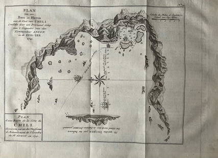
Sold2022Nautical chart of a unidentified bay in Chile. By the English pirate Anson 1749Title: Nautical chart of a unidentified bay in Chile. By the English pirate Anson 1749 Date/Period: 1749 Materials: Copper plate engraved Size: 13 1/2 x 9 3/4” Nautical chart of a unidentified BSee Sold Price
Sold2017Nautical Chart and Coastal Map of Monterey Bay, 1852Map: 1852 Nautical Chart and Coastal Map of Monterey Bay, California -- Monterey Harbor, CA from a Trigonometrical Survey Cartographer: US Coast Survey Year / Place: 1852 Map Dimensions: 13.1 x 11.7 iSee Sold Price
Sold2022(FLORIDA PANHANDLE.) Joseph Frederick Wallet des Barres. The North East Shore of the Gulph of(FLORIDA PANHANDLE.) Joseph Frederick Wallet des Barres. The North East Shore of the Gulph of Mexico. Large engraved coastal chart of western Florida from Apalachicola to Mobile Bay. 4 sheets of "LVG"See Sold Price
Sold2019Early map of San Francisco - 1853Reserve Reduced! Rare, hand-colored coastal chart of San Francisco and part of the Bay, with soundings. Extends to the Mission de Dolores and Pt. San Quentin. Shows street layout, buildings, wharfs, rSee Sold Price
Sold20161800's Chart Showing Penobscot Bay, MaineOriginal coastal survey from 1880 detailing Penobscot Bay from Belfast to Thomaston and as far east as Deer Isle. Mounted in a silver frame. Top of chart has minor loss. Overall Dimensions: 48" H x 40See Sold Price
Sold2022The Atlantic Coast Pilot (1878)A copy of The Atlantic Coast Pilot. Boston Bay to New York. By the United States Coast Survey. (Washington, D.C., 1878). With many engraved folding plates of coastal profiles and harbor charts.See Sold Price
Sold2018Large/scarce 1861 map of New York BayReserve Reduced! Large and scarce 1861 coastal map of New York City and its harbor. One of the earliest 19th century charts to depict New York City as we know it today. It shows Manhattan, Brooklyn anSee Sold Price
Sold2021Kerry Hallam Acrylic on Coastal Chart - Long IslandKerry Hallam (British 1937-2020) Acrylic on Coastal Chart - Long Island Sound, Nantucket Sound and New England Coastline, signed lower left 26 in. x 43.5 in. Overall 29.5 in. x 47.5 in. Dimensions 26See Sold Price
Sold20241918 George Eldridge Chart of Massachusetts BayRare early twentieth century chart of Cape Cod bay by George Eldridge showing Massachusetts Bay, and the coast from Chatham to Gloucester 1918. Signed George Eldridge. This great chart shows Chatham,See Sold Price
Sold2021Antique Coast Survey Map of the Atchafalaya BayAntique Coast Survey Map of the Atchafalaya Bay , "Preliminary Chart of Atchafalaya Bay Louisiana... A.D. Bache, Superintendant", 1858, lithograph, with later hand-coloring, sight 24 1/2 in. x 31 1/4See Sold Price
Sold2020MORTIER, PIERRE. Carte Particuliere de Virginie,MORTIER, PIERRE. Carte Particuliere de Virginie, Maryland, Pennsilvanie, la Nouvelle Jarsey Orient et Occidentale. Large double-page engraved chart of the Chesapeake Bay. 25x37 inches sheet size, wideSee Sold Price
Sold2023Large 1876 chart of Long Island Sound from Newport to New York. Compiled by George Eldridge, publishLarge 1876 chart of Long Island Sound from Newport to New York. Compiled by George Eldridge, published by S. Thaxter & Son, Boston. Nautical chart with notable coastal towns and landmarks. Canvas backSee Sold Price
Sold2022North Atlantic.Publication Date: 1874 Title: North Atlantic. Cartographer: IMRAY, JAMES F. Publisher: JAMES IMRAY & SON Height: 39.75 Width: 50 Blue-back sea chart with exhaustive soundings in coastal areas. Four inSee Sold Price
Sold2021Dana Bartlett (American/California, 1882-1957)Dana Bartlett (American/California, 1882-1957) "Coastal Scene with Yellow Rocks, Possibly Morro Bay" oil on canvas signed lower right, "George Stern Fine Arts" label on frame backing. Framed. 16" x 20See Sold Price
Sold2021A Fine Massachusetts Chippendale Mahogany Oxbow ChestWith blocked ends, Boston or coastal Massachusetts, 1775-1795. Height 32.5 inches, width 33.125 inches, depth 21.5 inches. In original condition, old surface and patina. Provenance: Nathan Liverant anSee Sold Price
Sold2023Grandma (Anna Robertson) Moses (1860 - 1961) AmericanGrandma (Anna Robertson) Moses (1860 - 1961) Oil and glitter on masonite Signed , measures 8" x 10" , w/frame 10" x 12"See Sold Price
Sold2021Molded and Incised Stoneware Railroad Pig Flask.Anna Pottery, Union County, Illinois, Dated 1881, length 8 inches. Provenance: Christie's New York, January 25, 2010.See Sold Price
Sold2022Anna Althea Hills (1882 - 1930) AmericanAnna Althea Hills (1882 - 1930) American, Oil/ Board Signed Lower Right. Measures 23" x 29"See Sold Price
Sold2022FREDERICK K. DETWILLER (American, 1882-1953)FREDERICK K. DETWILLER (American, 1882-1953), coastal landscape, (New Harbor, Maine), 1936, oil on board, signed lower right, initialed, dated and annotated on board verso, along with the artist's CarSee Sold Price
Sold2022Alfred Thompson Bricher (1837 - 1908) American "CoastalAlfred Thompson Bricher "Coastal Landscape",Watercolor /Paper ,Signed ,measures 15.5 x7.5 inchesSee Sold Price
Sold2021Very Large Pink Murano Bottle With Stopper.Overall height 18.5 inches. Excellent condition.See Sold Price
Sold2022William Trost Richards (1833 - 1905 )American "Coastal Seascape"William Trost Richards (1833 - 1905 )American "Coastal Seascape" Watercolor and gouache / Paper Signed, measures 9 x 11 inchesSee Sold Price
Jun 20Freeman's | HindmanFrançoise Gilot (French, 1921-2023) Mission Bay (Coastal View), c. 1979-1980$20,000
7 days LeftBonhamsAnna Pavlova: A pair of pink Satin Ballet Pointe Shoes worn by Anna Pavlova, c.1915, 2£1,200
3 hrs LeftJasper52South Namibia coast. Walvis Bay-Orange River ADMIRALTY sea chart 1881 (1954) map$85
Jun 13Swann Auction Galleries(HONDURAS -- ROATAN ISLAND.) Lieutenant Henry Barnsley; and William H. Toms, engraver. A Draught of$750
7 days LeftSouth Bay AuctionsMadeleine Lemaire (French 1845-1928), Set of (2) Still Life with Pink Roses$150(1 bid)
3 days LeftMichael's GalleryRalph Baker (Impressionist - Coastal Seacape) Signed Original Watercolor$500
Jun 13Swann Auction Galleries(NEW ENGLAND.) George Eldridge. A New Chart of the Coast of New England$600
3 hrs LeftJasper52West coast of Africa from Cape Blanco… Arguin bay, Mauritania. LABAT 1745 map$20