Sold2015American Heritage Early Maps of America Reproductions(6) maps include the New World 1500 & 1600, New France 1745, the Known Globe 1667, and more, also includes a collection of noteble early maps of America Booklet See Sold Price
Sold2018World and Tartary MapsAmerican Heritage and other reproduction maps. 17-1/2" x 22" approx.See Sold Price
2017Reiner Ottens American Heritage Map of New FranceMap: Map entitled "New France 1745 drawn by Reiner Ottens". Maker: Reiner Ottens Publisher: American Heritage Size: approximately 24 inches high x 18 inches wide It’s a reproduction by American HeriSee Sold Price
Sold20221777 Revolutionary War Map AMERICA SEPTENTRIKONALHistoric Maps 1777 AMERICA SEPTENTRIKONALIS... Homann Heirs 1777-Dated American Revolutionary War Period, Hand-Colored Engraved Map titled, "AMERICA SEPTENTRIKONALIS...," by Homann Heirs, Nuremberg, CSee Sold Price
Sold2022c. 1703 Map AMERICA by Peter Heylyn Calif. IslandHistoric Maps Rare Circa 1703 Hand-Colored Engraved Map titled: "AMERICA" with California as an Island by Peter Heylyn c. 1703 Hand-Colored Engraved Map titled "AMERICA" by Peter Heylyn, showing CalifSee Sold Price
2017Juan de la Cosa "Map of the New World 1500"Item: Juan de la Cosa "Map of the New World 1500" Description: Vintage reproduction map drawn by Juan De La Cosa By American Heritage, the magazine of history Dimensions: 24” x 18” Please note thaSee Sold Price
Sold20211721 Map of America With California as an IslandHistoric Maps 1721 Hand-Colored "A New Map of America from the Latest Observations" with "California" Shown as an Island 1721 Hand-Colored Engraved Western Hemisphere Map titled, "A New Map of AmericaSee Sold Price
Sold2023c 1706 Pieter Van Der Aa North + South America Map as 1st Discovered by ColumbusHistoric Maps 1706 North & South America Map Discovered by Columbus First Voyage Published by Dutch Map Pieter Van Der Aa (1659-1733) c. 1706-1708, Original Map of North & South America (translated) tSee Sold Price
Sold20231844 ATLAS Geography 19 MAPS Early America United States Southern School1844 ATLAS Geography 19 MAPS Early America United States Southern School Jesse Olney was a 19th-century American historian who published a number geographical and history readers including his famousSee Sold Price
Sold20158 Books American Houses & Decoration100 Most Beautiful Rooms in Amer., Great Houses of American History, Bonnet House (author signed), Amer. Classicist, Heritage Early Amer. Houses, America's Small Homes, Early Amer. Homes, Amer. InteriSee Sold Price
Sold2016JOHN MELISH (SCOTLAND/AMERICAN 1771-1822), EARLY ANDJOHN MELISH (SCOTLAND/AMERICAN 1771-1822), EARLY AND RARE MAP OF THE UNITED STATES OF AMERICA, C.1813. ENTERED AS THE ACT DIRECTS AND PUBLISHED BY JOHN MELISH, PHILADELPHIA, JUNE 1813. SIGHT 13 X 17 1See Sold Price
Sold20221755 Map of North America by De VaugondyHistoric Maps 1755 French & Indian War Era Map of North America by De Vaugondy 1755-Dated French & Indian War Era, Large Hand-Colored Map titled, "PARTIE DE L'AMERIQUE SEPTENTRIONALE, QUI COMPREND LESee Sold Price
Sold20241755 French & Indian War Period, Map of the NORTH AMERICAN BRITISH + FRENCH SETTLEMENTSHistoric Maps 1755 French & Indian War "A Map of the BRITISH and FRENCH SETTLEMENTS in NORTH AMERICA" 1755 French and Indian War Period, Map of North America titled, "A Map of the British and French SSee Sold Price
Sold2021c 1730 Seutter Map: Novi Belgii, in America ...Historic Maps c. 1730 Historic Rare Earlier State of Seutter's Important American Northeast Map & New York City Restitutio View c. 1730 Hand-Colored Copper-Engraved Map titled, "Recens Edita totius NoSee Sold Price
Sold20221765 Atlas Map of North + South AMERICA, ExpillyHistoric Maps 1765 Atlas Map of North and South AMERICA by Expilly 1765 Copper Engraved Atlas Map of North and South AMERICA titled, "AMERIQUE Septentrionale et Meridionale," from Le Geographe ManuelSee Sold Price
Sold20222 Early American History Books1777 Introduction to the History of America (has foldout Map of US and Canada), 1834 History of United States of America by Charles A. Goodrich. 1777 Book in Good condition, slight page discoloration,See Sold Price
Sold2020Early Civil War era map of AmericaNice example of A. J. Johnson's 1862 map of North America. Presents a fascinating snapshot of North America just after the outbreak of the American Civil War. States generally follow the 1861 configurSee Sold Price
Sold20231810 Modern Geography America MAP + World Map Massachusetts Elijah Parish1810 Modern Geography America MAP + World Map Massachusetts Elijah Parish Elijah Parishs “New System of Modern Geography” is an early 19th-century American geography textbook. Published inSee Sold Price
Sold2023The Original Water-Color Paintings by John James Audubon...The Original Water-Color Paintings by John James Audubon......for The Birds of America (New York: American Heritage Publishing Co., Inc., 1966), two volumes in slipcase with reproductions of works inSee Sold Price
Sold20221818 Map I Stati Uniti Nell America SettentrionaleHistoric Maps 1818 Rare Map Titled "I Stati Uniti Nell' America Settentrionale" by A.B. Borghi, Florence, Italy Choice Crisp Near Mint 1818-Dated, Four-Sheet Copper-Engraved, Hand-Colored Outlines, MaSee Sold Price
Sold20221770 MAP OF THE AMERICAS By ANTONIO ZATTAHistoric Maps Hand-Colored MAP OF THE AMERICAS, "L'America divisa Ne Suoi Principali Stati Di Nuova Projesione" by Antonio Zatta 1770 Hand-Colored Engraved MAP OF THE AMERICAS titled, "L'America divisSee Sold Price
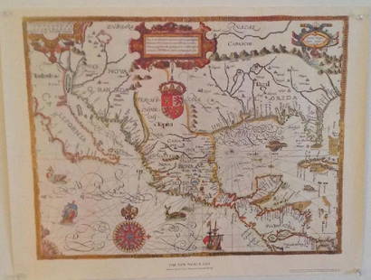
Sold2017Gabriel Tatton: The New World Map, 1600The New World Map 1600” drawn by Gabriel Tatton - reproduction by American Heritage, the magazine of history. Measurement approximate: 24” x 18”. Condition: Very Good Please note that this lSee Sold Price
Sold20221720 Virginia Manuscript Deed + Map Plot DocumentColonial America 1720 Manuscript Deed and Map Plot Document, Virginia April 2, 1720-Dated Early Colonial Era, American Manuscript Deed and Map Plot Document, Northumberland County Virginia, with integSee Sold Price
Sold2023Map of the American Colonies from December, 1754This map is titled 'An Accurate Map of the English Colonies in North America bordering on the River Ohio', a scarce early map of the British Colonies in North America and one of the earliest maps to aSee Sold Price
2 days LeftTrillium Antique Prints & Rare BooksAudubon - Black-Crowned Night Heron or Qua Bird. 363$25
May 17Ni-Cola Classics - Automobilia Auction & Classic Car SalesBuch 29-parts American automobiles from the 50s-80s€80