Sold2023AFRICAN PORTS.Alexandria Cape Town Cairo Port Natal(Durban).JOHNSTON 1906 mapTITLE/CONTENT OF MAP: 'Alexandria; The cape; Cairo; Durban and Port Natal; Cape Town' DATE PRINTED: 1906 IMAGE SIZE: Approx 20.0 x 26.5cm, 8 x 10.5 inches (Medium) TYPE: Antique colour map CONDITION:See Sold Price
Sold2023AFRICAN PORTS. Alexandria Cape Town Cairo Port Natal Durban. JOHNSTON 1901 mapTITLE/CONTENT OF MAP: 'Alexandria; The Cape; Cairo; Durban and Port Natal; Cape Town' DATE PRINTED: 1901 IMAGE SIZE: Approx 20.5 x 27.0cm, 8 x 10.5 inches (Medium) TYPE: Antique colour atlas map CONDISee Sold Price
Sold20241894 Johnston Map of Oceania [verso] Island in the Indian Ocean and Near Africa -- Oceania [verso]Title: 1894 Johnston Map of Oceania [verso] Island in the Indian Ocean and Near Africa -- Oceania [verso] Madagascar; Mauritius; Seychelles; Cape Town; St. Helena and Ascension Islands; Socotra; AdenSee Sold Price
Sold2022Africa.- Weinthal (Leo) The Story of the Cape to Cairo Railway and River Route, 4 vol. including mapAfrica.- Weinthal (Leo) The Story of the Cape to Cairo Railway and River Route, 4 vol. including map and index vol., (without separately-published supplement volume), maps, plates and illustrations, sSee Sold Price
Sold2021Jack & Bartholomew 1885 Mixed Lot of 21 MapsIncl Aral Sea, Cape Colony, French Ports, Alps, Algiers, Central Africa, Azores, Bristol Channel, Brazil, Borneo, Faroe Islands, Egypt, Dutch Guyana, Dublin, Fiji/Cyprus, Crimea, Belfast/Cork, ConstanSee Sold Price
Sold2022(MANUSCRIPT MAP -- CAPE TOWN.) Vue de Cap de Bonne Esperence.(MANUSCRIPT MAP -- CAPE TOWN.) Vue de Cap de Bonne Esperence. Pen and ink and watercolor wash on laid paper. 12¾x22¾ inches sheet size, ample margins; stain at right edge, backed with thin tSee Sold Price
Sold20191753 SlaveTrade Map of Africa Cape Blanco to AngolaSlave Trade map “A new and correct Map of the Coast of Africa from Cape Blanco ..to the Coast of Angola”, printed from J and P Knapton, 1753 and for Universal Dictionary of Commerce. Fine foldingSee Sold Price
Sold2021View of a Coastal IslandOil on canvas, with a view of a well inhabited island, showing boats, possibly depicting a rare view of Marion Island in Cape Town, South Africa (see Colonial British flags flown in the boats). 17in.See Sold Price
Sold2023FREDERICK HUTCHINSON PAGE, "DISTRICT SIX", GOUACHEFrederick Hutchinson Page (South African 1908-1984), "District Six", Cape Town, 1972, gouache on waterdiscolor board depicting an architectural landscape with white buildings, signed and dated to loweSee Sold Price
Sold2017Moll - Correct Map of the Whole World, 1719Herman Moll (1654?-1732), cartographer and publisher A New & Correct Map of the Whole World Shewing y.e Situation of its Principal Parts. Viz the Oceans, Kingdoms, Rivers, Capes, Ports, Mountains, WooSee Sold Price
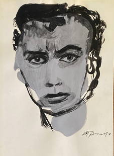
Sold2021Marlene DumasDrawing on paper, 10 1/2 x 7 1/2 in, manner of Marlene Dumas (born 1953) is a contemporary South African artist and painter currently based in the Netherlands. Dumas was born in 1953 in Cape Town, SouSee Sold Price
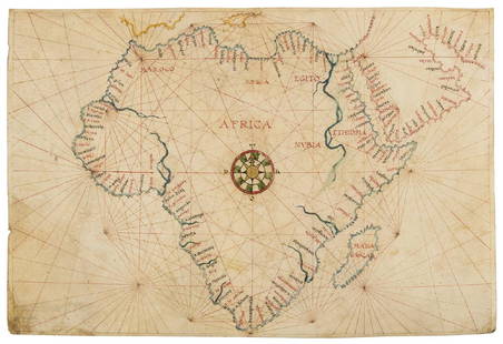
Sold2019Africa.- Agnese (Manner of Battista, c.1500-1564)Africa.- Agnese (Manner of Battista, c.1500-1564) Portolan chart of Africa and the Arabian Peninsula, large compass rose with port towns and cities annotated, pen and inks, watercolour wash, heighteneSee Sold Price
Sold2022(MANUSCRIPT MAP -- SICILY.) Carta Topografica della Citta d'Agosta Co'suoi Contorni.(MANUSCRIPT MAP -- SICILY.) Carta Topografica della Citta d'Agosta Co'suoi Contorni. Pen, ink, and wash-colored plan of the ports and town of ancient Augusta on the Ionian coast of Sicily. Heavy laidSee Sold Price
Sold2019Carte d'une partie de l'Amerique pour la navigation'The towns of Saint Augustine, Savannah and Port Royal are marked on the Atlantic seaboard of the United States DATE PRINTED: 1740 (This date is printed on the map) IMAGE SIZE: Approx 53.0 x 69.5cm, 21See Sold Price
Sold2022African Cape Buffalo Pedestal Taxidermy Mount52.1 Nice clean mount finished back on walnut pedestalSee Sold Price
Sold2022Capetown Certified Pre-Owned Gent's 18K Yellow Gold 44mm Rolex "Yachtmaster II"White Dial with Yellow Gold Luminescent Hands and Hour Markers Subsidiary Seconds Hand Red Center Sweep Chronograph Seconds Hand.18K Yellow Gold Ring Command-Bidirectional Rotating Bezel with Blue CerSee Sold Price
Sold2022Capetown Certified Pre-Owned Gent's Stainless Steel 44mm Rolex "Yachtmaster II" ChronographWhite Dial with Black Arabic Numerals Blue Luminescent Hands and Markers Subsidiary Seconds Hand.Bidirectional Rotatable Ring Command Bezel with Blue Ceramic Insert Regatta Chronograph Functions Red CSee Sold Price
Sold2022Capetown Certified Pre-Owned Gent's Stainless Steel 40mm Rolex "Milgauss"Black Dial with White Gold Luminescent Hands and Index Hour Markers Luminescent Orange Hour Markers at 36 and 9.Stainless Steel Smooth Bezel Orange Lightning Bolt-Shaped Center Sweep Seconds Hand SpecSee Sold Price
Sold2022Pre-Owned Capetown Certified Gent's Stainless Steel & 18K Yellow Gold 36mm Rolex "Datejust"White Dial with Yellow Gold Hands and Roman Numerals Center Sweep Seconds Hand.18K Yellow Gold Fluted Bezel Alternative Black & Red Date Indicator Quickset Movement Sapphire Crystal.Matching StainlessSee Sold Price
Sold2024A Chinese black-glazed pottery vaseA Chinese black-glazed pottery vase, Yuhuchun ping, late Song or Jin Dynasty, 12-13th century, the base with exhibition labels for Cape Town 1953, Radcliffe collection 'A22', Bluett & Sons London andSee Sold Price
Sold2022Lionel Smit, Merge #3Lionel Smit Merge #3 2013oil on canvas 47.5 h × 47.5 w in (121 × 121 cm) Signed and dated to lower right 'Lionel Smit 2013'. Provenance: Everard Read, CapeSee Sold Price
Sold2017Forlani: Antique Map, Town View of Venice, 1569Title: Venetia, Splendid 1569 Lafreri-school town view of Venice Map maker: Paolo Forlani, De’ disegni delle più illustri città et fortezze del mondo Place and Year: Venice, 1569 Dimensions: 19.2See Sold Price
Sold2022MAP, Africa, OrteliusOrtelius' Cornerstone Map of Africa. Africa. Abraham Ortelius, Africae Tabula Nova, from Theatrum Orbis Terrarum, 1570 (dated). Black & White. This striking map is one of the cornerstone maps of AfricSee Sold Price
Sold2021Hand colored map, Africa. 23” x 20.5”Hand colored map, Africa. 23” x 20.5”See Sold Price
5 days LeftMynt Auctions1932 Greece Airmail First Flight Cover FFC Athens to Cape Town South Africa$270
5 days LeftMynt Auctions1934 Cape Town South Africa Airmail First Flight Cover To Suva Fiji Via Sydney$270
Jun 07AUTOMOBILIA LADENBURG AUCTIONMASERATI 1937, original B/W photo Piero Taruffi in a Maserati 8CM (#3005), 1st Grosvenor Grand Prix€80
4 days LeftMynt Auctions1925 British South Africa Special Airmail Postcard Cover Cape Town to Pretoria$560
2 days LeftThousand Planet Auction HouseA Collection of Antique African Trade Beads, 16th-19th Century$10
2 days LeftThousand Planet Auction HouseA Collection of Antique African Trade Beads, 16th-19th Century$10
2 days LeftThousand Planet Auction HouseLot of Antique African Monochrome Glass Beads, c. 1800-1900$10
2 days LeftRapid Estate Liquidators and Auction Gallery3 Pasta Bromberg Bros Blue Ribbon Meat Cookbooks$45
1 day LeftJasper521575 Braun and Hogenberg View of Sluis, Netherlands -- Sluys. Slusa, Teutonicae Flandriae Opp.$200
3 days LeftForum AuctionsMeer (Fatima) Higher Than Hope: A Biography of Nelson Mandela, first English edition, signed£800


![1894 Johnston Map of Oceania [verso] Island in the Indian Ocean and Near Africa -- Oceania [verso]: Title: 1894 Johnston Map of Oceania [verso] Island in the Indian Ocean and Near Africa -- Oceania [verso] Madagascar; Mauritius; Seychelles; Cape Town; St. Helena and Ascension Islands; Socotra; Aden](https://p1.liveauctioneers.com/5584/328338/176911535_1_x.jpg?height=310&quality=70&version=1715113718)


![[MAP]. ORTELIUS, Abraham. Africae Tabula Nova. 1592. (1 of 2)](https://p1.liveauctioneers.com/197/329395/177650533_1_x.jpg?height=282&quality=70&version=1715364962)
