Sold2022Adirondack Book and 1908 MapThrough the Adirondacks in 18 days by Martin V. B. Ives, 1899. And a 1908 Adirondack Map. Also includes: Newcomb, NY Lake Harris House Brochure, Schroon Lake and Paradox Lake Turn of the Century BooklSee Sold Price
Sold2022Adirondack Map 1908Adirondack Maps 1908 New York State 3 Maps Present - Southeast - Northwest - Northeast Publisher State of New York Dated: 1908 Condition Report GoodSee Sold Price
Sold2016Adirondack NY Fishing, Maps History BooksA group of 3 books. 1. Hallock, Charles. The Fishing Tourist; Angler's Guide and Reference Book. New York Harper & Bros. 1873 (Front cover partially detached). Illustrated.2. 1900 Adirondack Maps StatSee Sold Price
Sold20219 Adirondack Mountain Maps & Pamphlets,1870-90'sCollection 1870s Adirondack Mountain Maps & Pamphlets. Includes the historic Preliminary Survey of the Adirondacks made by Verplanck Colvin in 1893, two "Birch Bark from the Adirondacks" books from 18See Sold Price
Sold2024RAND, McNALLY & CO.S ENLARGED BUSINESS ATLAS ( with Maps ) 1908, large format, complete 397 pages,RAND, McNALLY & CO.S ENLARGED BUSINESS ATLAS ( with Maps ) 1908, large format, complete 397 pages, loose spine, and some wear to cover edges. Book measures 21" x 15.5". From Hudson Valley estate.See Sold Price
Sold2022Adirondack Wilderness Topo Survey by ColvinTwo books. Second report from 1873-1874 signed by Verplanck Colvin and includes pull out map. Third to Seventh Report 1874-1879. Both books have several maps.See Sold Price
Sold2022Adirondacks Illustrated 1874 Book by S.R. Stoddardincludes map in very good condition. Binder faded.See Sold Price
Sold2023[DAKOTA]. The Mercantile Agency Reference Book (And Key) with A List of Banks and Bankers, State[DAKOTA]. The Mercantile Agency Reference Book (And Key) with A List of Banks and Bankers, State Collection Laws, Maps, Etc. New York: R. G. Dun & Co., 1908. Square 8vo. Two maps of North Dakota printSee Sold Price
Sold2018Gertrude Lowthian Bell SYRIA THE DESERT & THE SOWN 1908Gertrude Lowthian Bell SYRIA THE DESERT & THE SOWN 1908 Scarce Early Printing Photographs Illustrated Folding Map like Damascus Jerusalem Beirut Antioch Alexandretta Mecca Kadesh Mashennef Lebanon MonSee Sold Price
Sold20192V ANNUAL REPORTS OF THE FOREST FISH AND GAME2V ANNUAL REPORTS OF THE FOREST FISH AND GAME COMMISSIONER OF THE STATE OF NEW YORK 1897 1907-1909 Illustrated Chromolithograph Fish Animals Map Adirondack Denton Gillette Maple Syrup This auction lotSee Sold Price
Sold2024[FOLDING MAPS] PORT BURWELL & LONG POINT, ON + 26FOLDING MAPS. A lot of 27 folding topographical maps sold together: 2 of Ontario, 25 European. Including LARGE MAP OF PORT BURWELL & LONG POINT, ONTARIO. Original survey done in 1908 by Department ofSee Sold Price
Sold20221908 PERU 1ed Old New Illustrated Travel Guide Wright1908 PERU 1ed Old New Illustrated Travel Guide Wright Landscapes Portraits + MAP Marie Wrights Old and the New Peru is a charming and richly illustrated historical account of Peru. Wright was best-knoSee Sold Price
Sold2024Antique Albums w/ Postcards, Yosemite Photos,More - Car Photos, (1)Travel Book w/ US Map, Berkeley,Antique Albums w/ Postcards, Yosemite Photos,More - Car Photos, (1)Travel Book w/ US Map, Berkeley, Yosemite, San Francisco, YellowStone, More - Travel Album Circa 1908See Sold Price
Sold2024Crams Colored Railway Map and Shippers Guide of South Dakota 1908-1909This is a Crams Colored Railway Map and Shippers Guide of South Dakota for the years of 1908-1909. We could not find a date in the book or on the map, aside from a reference to railroad mileage from 1See Sold Price
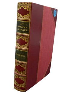
Sold2023RARE 1908 FIRST EDITION LEATHER BOUND WINSTON CHURCHILL "MY AFRICAN JOURNEY"Rare first edition leather bound "My African Journey" by Winston Churchill featuring gilt spine and fine detailing. Includes many photographs, illustrations, and maps within the book from Churchill'sSee Sold Price
Sold2019Travelers Lot With Post CardsIncluding two automotive blue books 1917 and 1922, Two early telephone directories 1908 1955, two travel tickets, portfolio of oyster bay and Bayville maps. Plus 9 various travel books and approx. fifSee Sold Price
Sold2024Adirondack Maps (4) [179293]Adirondack Mountains maps (4) from 1902, contained in a nice hardcover jacket. Each map measures 35"x by 27" and each cover different areas. including the northwest, southwest, northeast and southeastSee Sold Price
Sold2021Southern Pacific Railroad Book & Map Bonanza [128129]If you are a rail fan, especially a fan of The Southern Pacific Railroad, then this is the collection for you. It starts off with ten (10) team track maps (11"x 17") showing the various routes and swiSee Sold Price
Sold2021Framed Contemporary Fish Chart & Adirondack MapTrout, Salmon & Char of North America measures 25" x 40". Adirondack Map Northville-Placid Trail #33/50 measures 25" x 37".See Sold Price
Sold20221895 Adirondack Mapfolded and in original binder. Includes all 4 quadrants. Some water damage to back of binder.See Sold Price
Sold2022Catskills & Adirondack Book Lot (7 Books)This is a collection of (7) rare and antique books on the history and geography of New York State's Adirondack and Catskill mountains and their inhabitants: <1> Our Catskill Mountains, H.A. Haring, G.See Sold Price
Sold2023Framed 1908 Map of the Olympics Held in London, EnglandOriginal 1908 Map of the Olympics held in London, England idenifying all of the arenas and locations where events were to be held. Hardwood frame was painted a pinkish mauve many years ago, measuringSee Sold Price
Sold2023Atq / Vtg Ephemera, WWII, Car Manuals, Ads,More - War Map, 1840 Book, Maps, Postcards, 1937 GoodrichAtq / Vtg Ephemera, WWII, Car Manuals, Ads,More - War Map, 1840 Book, Maps, Postcards, 1937 Goodrich Almanac, 1968 Chevy, MoreSee Sold Price
Sold2023Lot of Vintage Postcards, Pokemon Book, Map of Asbury Park and MoreLot of Vintage Postcards, Pokemon Book, Map of Asbury Park and MoreSee Sold Price
Jun 12Dan Morphy AuctionsPHELPS’S TRAVELERS GUIDE THROUGH THE UNITED STATES; CONTAINING UPWARDS OF SEVEN HUNDRED$1,000
1818 AuctioneersMaps. Lake District interest. Cumberland and Westmorland Antiquarian and Archaeological Society£16
3 days LeftTrillium Antique Prints & Rare BooksDe Jode, Rare, pub. 1593 - Map of the Holy Land (Descriptio Et Situs Terrae Sanctae Alio Nomine$100(1 bid)
3 hrs LeftRapid Estate Liquidators and Auction Gallery1908 Antique Illustrated Book - 1st Edition "Jewels from Eugene Field"$25
2 days LeftRapid Estate Liquidators and Auction GalleryPaperback Copy Of Vers La Bérésina 1812 By General Major B.-R.-F. Van Vlijmen Librairie Plon 1908$150
23 hrs LeftRapid Estate Liquidators and Auction Gallery1908 Lettres Du Commandant Coudreux Softcover Book$40
23 hrs LeftRapid Estate Liquidators and Auction GalleryColonel Lussan Souvenirs Du Mexique Softcover$50
3 hrs LeftRapid Estate Liquidators and Auction Gallery1908 Deutschlands Ehr` Im Weltenmeer Hardcover Book$50
Jun 08Connoisseur AuctionsEarly 1900's Railway Service Map, Illinois, Ohio, Indiana, Kentucky, Tennessee$20
Jun 23Schilb Antiquarian Rare Books1977 JRR Tolkien 1st ed Silmarillion Lord of the Rings Middle Earth + MAP$1(1 bid)
Jun 23Schilb Antiquarian Rare Books1870 BEAUTIFUL Life of Jesus Christ Fleetwood Bible ART Miracles Jerusalem Map$1
Jun 23Schilb Antiquarian Rare Books1848 Emory Military Reconnaissance 1ed California MAP Indians Texas New Mexico$1
Jun 23Schilb Antiquarian Rare Books1790 Life of Jesus Christ Fleetwood Bible ART Miracles Jerusalem MAP Holy Land$1
7 days LeftThomaston Place Auction GalleriesCOLLECTION OF TRAVEL EPHEMERA, BROCHURES, BOOKLETS, MAPS 1900-1950$100


![[DAKOTA]. The Mercantile Agency Reference Book (And Key) with A List of Banks and Bankers, State: [DAKOTA]. The Mercantile Agency Reference Book (And Key) with A List of Banks and Bankers, State Collection Laws, Maps, Etc. New York: R. G. Dun & Co., 1908. Square 8vo. Two maps of North Dakota print](https://p1.liveauctioneers.com/197/290824/154051809_1_x.jpg?height=310&quality=70&version=1685134375)


![[FOLDING MAPS] PORT BURWELL & LONG POINT, ON + 26: FOLDING MAPS. A lot of 27 folding topographical maps sold together: 2 of Ontario, 25 European. Including LARGE MAP OF PORT BURWELL & LONG POINT, ONTARIO. Original survey done in 1908 by Department of](https://p1.liveauctioneers.com/8124/322212/173235020_1_x.jpg?height=310&quality=70&version=1709937662)


![Adirondack Maps (4) [179293]: Adirondack Mountains maps (4) from 1902, contained in a nice hardcover jacket. Each map measures 35"x by 27" and each cover different areas. including the northwest, southwest, northeast and southeast](https://p1.liveauctioneers.com/2699/324080/174413226_1_x.jpg?height=310&quality=70&version=1711485545)
![Southern Pacific Railroad Book & Map Bonanza [128129]: If you are a rail fan, especially a fan of The Southern Pacific Railroad, then this is the collection for you. It starts off with ten (10) team track maps (11"x 17") showing the various routes and swi](https://p1.liveauctioneers.com/2699/222982/114969765_1_x.jpg?height=310&quality=70&version=1634754101)


