Sold2021MAP OF NEW YORK PERTAINING TO THE REVOLUTIONARY WARMAP OF NEW YORK PERTAINING TO THE REVOLUTIONARY WAR BATTLE OF BROOKLYN HEIGHTS"A Plan of New York Island, part of Long Island &c. shewing the Position of the American and British Armies, before,See Sold Price
Sold20181776 Map of Country Round Philadelphia New JerseyA Map of the Country round Philadelphia including Part of New Jersey New York, Staten Island and Long Island, published for Gentleman's Magazine, London, 1776. Fine condition, folds as issued, measureSee Sold Price
Sold2021A 1776 Map of Philadelphia, New Jersey, Etc..."A Map of the Country round Philadelphia including Part of New Jersey NewYork, Staten Island and Long Island", published for Gentleman's Magazine, London, 1776. Dimensions: Sight is 7 1/4" x 9", the fSee Sold Price
Sold20191832 Marshall Revolutionary War Map of New York City --Title/Content of Map: 1832 Marshall Revolutionary War Map of New York City -- Plan of New York Island and Part of Long Island Shewing the Position of the American & British Armies before, at, and afteSee Sold Price
Sold2023Map: United States– East Coast / Connecticut– New York/ Long Island Western PartDescription: United States– East Coast / Connecticut– New York/ Long Island Western Part. Published at Washington D.C. US Department of Commerce, National Oceanic Service. Measurement apSee Sold Price
Sold2018A&C Black: Map of New York & Part of New England, 1874Title/Content of Map: New York, Vermont, New Hampshire, Rhode Island, Massachusetts & Connecticut Cartographer: A. and C. Black Place & Date: Edinburgh / 1874 Size: 21 3/4" x 16" Condition: full colorSee Sold Price
Sold2023MAP: United States - East Coast. Connecticut - New York. Long Island Sound - Eastern PartDescription: United States - East Coast. . Connecticut - New York. Long Island Sound - Eastern Part. Published at Washington D.C. US Department of Commerce, Environmental Science services AdministratiSee Sold Price
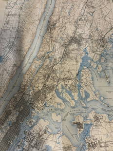
Sold2020Nautical Map / Sea Chart, #1212 Eastern Long IslandDescription: Nautical Map / Sea Chart, United States East Coast, Connecticut - New York, Long Island Sound, Eastern Part, 12th edition feb 10 / 69 ; all measurements are approximate; Folded; ShippingSee Sold Price
Sold2016MAP OF NEW YORK, THOMAS KITCHIN, 1756A MAP OF THE EASTERN PART OF THE PROVINCE OF NEW YORK, WITH PART OF NEW JERSEY, showing Pennsylvania, New York state, Long Island, Connecticut and New Hampshire, with Lake OntarioSee Sold Price
Sold20231758 Folding Map of New England and Nova ScotiaA Map of New England and Nova Scotia with part of New York, Canada, and New Britain and the adjacent Islands of New Found Land and Cae Breton, by Thomas Kitchin, printed at London for London Magazine,See Sold Price
Sold20201917 Map of CubaTitle: 1917 Map of Cuba Medium: Ink on Paper Dimensions: 8"X6" Map of the island of Cuba dated 1917. Published by Hammond and co in New York. Part of the Handy Atlas of the World. Color coded for terrSee Sold Price
Sold20201917 Map of the Virgin IslandsAuthor: Hammond Title: 1917 Map of the Virgin Islands Medium: Ink on Paper Dimensions: 8"X6" Map of the Virgin Islands dated 1917. Published by Hammond and co in New York. Part of the Handy Atlas of tSee Sold Price
Sold2017Buache: Antique Map of New York, Long Island, 1807Map: Ile de New-York Partie de Long-Island ou de l'Ile Longue et positions des armées Américaine et Britannique après le combat livré sur les hauteurs, le 27 Août, 1776. Maker: Buache, Jean NicolSee Sold Price
Sold20231742 Map of Part Of New York 1742 David GrimMap of Part Of New York- Showing the site of the present Park the Collect and Little Collect Ponds; and a portion of the west side of Broadway. 1742 David Grim 11x7, hand colored with details of an agSee Sold Price
Sold2024Black and white map of part of New York City (mostly Manhattan)Black and white map of part of New York City (mostly Manhattan), published 1911, Encyclopædia Britannica, 11th ed., Vol. 19, between pp. 610 and 611.Size: 29 cm x 22 cmSee Sold Price
Sold2021EARLY FRAMED NYC MAP, PART OF WARD 9, NEW YORK CITYEARLY FRAMED NYC MAP, PART OF WARD 9, NEW YORK CITY PART OF SECTION 2, FRAMED AND MATTED, MAKER OR DATE UNKNOWN. MAP MEASURES 23" X 32". IN VERY NICE ESTATE CONDITION, FROM WOODSTOCK, N.Y. ESTATE.See Sold Price
Sold2020Map of a Part of New York, New Jersey, Pennsylvania,Title: Map of a Part of New York, New Jersey, Pennsylvania, Virginia, N. Carolina, S. Carolina, & Georgia. Publication Date: 1833 Cartographer: ANONYMOUS Size: 7.5Height - 6.1Width Showing the operatiSee Sold Price
Sold2018New York City (Southern Part). | Map of New York CityTitle: New York City (Southern Part). | Map of New York City (Northern Part). Publication Date: 1892 ca. Cartographer: FISK & CO. Publisher: HUNT & EATON Size: 11x8.6 The People's Cyclopedia map. PleaSee Sold Price
Sold2024(45)1930s-50s Road Maps, Railroad,More - 1944 New York Central & Long Island Railroad Time Tables,(45)1930s-50s Road Maps, Railroad,More - 1944 New York Central & Long Island Railroad Time Tables, Maps - NY, Ohio, Kentucky, Tennessee, Indiana, Kansas, New Jersey + MoreSee Sold Price
Sold2023Group lot of NEW YORK State Topographical MapsGroup lot of NEW YORK State Topographical Maps, maps measure 17 x 21 inches, wear consistent with age and use. not framed. Art, wall art, artwork, home decor, maps, topographic, topography, New York SSee Sold Price
Sold2022Group lot of NEW YORK State Topographical MapsGroup lot of NEW YORK State Topographical Maps, maps measure 17 x 21 inches, wear consistent with age and use. not framed. Art, wall art, artwork, home decor, maps, topographic, topography, New York SSee Sold Price
Sold20231902 Cram Map of Long Island -- Map of Long Island New YorkTitle: 1902 Cram Map of Long Island -- Map of Long Island New York Cartographer: G Cram Year/Place: 1902, Chicago Dimensions: 9.8 X 12.4 in. Description: This is an attractive map of Long island withSee Sold Price
Sold2022ANTIQUE NEW YORK TOPOGRAPHICAL ATLAS MAPS DOCSAn antique edition of New topographical atlas of Jefferson Co., New York published in 1864. Also includes more antique maps and documents. Dimensions: N/ASee Sold Price
Sold2022Colton's Mexico, 1861COLTON, Joseph Hutchins (1800 - 1893). Colton's Mexico. Lithographed map with original hand color in part. New York; J.H. Colton, 1861. 13 1/2" x 16 1/2" sheet. Provenance: Ink library stamp of a schoSee Sold Price
Jun 06Freeman's | HindmanMELVILLE, Herbert (1819-1891). Typee: A Peep at Polynesian Life. During a Four Months' Residence in$200
Jun 06Freeman's | HindmanSTEVENSON, Robert Louis (1850-1894). Treasure Island. London, Paris & New York: Cassell & Company,$1,500
Jun 23Schilb Antiquarian Rare Books1877 Geology Geography Surveys 1ed Nevada Wyoming Utah George Wheeler US West 2v$1
May 26Robinhood AuctionsCharles Fazzino, "There's Music: New Jersey, New York, Long Island Too!!" Framed 3D Limited Edition$1,000
4 days LeftHess Fine AuctionsBulova Japan Mid Century MCM Mod Pedestal Battery Operated Desk Mantel Clock MHP Collection$30(3 bids)
4 days LeftHess Fine AuctionsButterscotch Bakelite Plymouth 8 Days Art Deco Desk Mantel Clock MHP Collection$200(3 bids)
4 days LeftHess Fine AuctionsBakelite Art Deco Seth Thomas 8 Days Star Pedestal Desk Mantel Clock MHP Collection$80(3 bids)
4 days LeftHess Fine AuctionsLux Waterbury Steamship Desk Clock Nautical Mechanical MHP Collection$90(3 bids)
4 days LeftHess Fine AuctionsJefferson 500 MCM Space Age Atomic Electric Desk Clock Reverse Crystal MHP Collection$20(2 bids)