Sold20239 cartes de basketball9 cartes de basketball Description: 1997 22KT gold Michael Jordan, 2019 Panini Prizm Coby White Graded 9, 1994 UD Grant Hill Graded 9, 2002 Topps Amare Stoudemire RC Graded 10, 1997-98 Hoops Tracy McGSee Sold Price
Sold2022Civil War Non-Commissioned Officers CDV's, GroupingCivil War carte de visite photographs (9) of unidentified non-commissioned officers. Grouping includes; 1.) Standing knees-up view of sergeant wearing 4-button jacket and kepi with large 3rd corps badSee Sold Price
Sold2022Civil War Officers CDV's, GroupingCivil War carte de visite photographs (9) of unidentified officers. Grouping includes; 1.) Bust view of officer wearing 9-button jacket and lieutenant's shoulder rank straps. Carte backmarked Lemer, HSee Sold Price
Sold2022Civil War Officers CDV's, GroupingCivil War carte de visite photographs (9) of unidentified officers. Grouping includes; 1.) Waist-up view of officer wearing 4-button jacket and captain's shoulder rank straps. Carte lacks backmark. ReSee Sold Price
Sold2023CIVIL WAR EPHEMERACIVIL WAR EPHEMERAAmerican, 19th century, paper ephemera. Nine (9) Civil War related items: a carte de visite of a Union soldier taken by Reynolds and Wisner of St. Louis, Missouri; a letter in its &qSee Sold Price
Sold2018ANTIQUE ICON & ANTIQUE PARIS ITINERARY MAPHand painted icon signed & dated 1832 - 12.25" h x 9.25" w plus antique Carte Routiere De Dion-Bouton Environs De Paris itinerary mapSee Sold Price
Sold2018ANTIQUE ICON & ANTIQUE PARIS ITINERARY MAPHand painted icon signed & dated 1832 - 12.25" h x 9.25" w plus antique Carte Routiere De Dion-Bouton Environs De Paris itinerary mapSee Sold Price
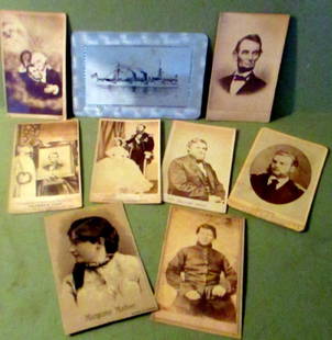
Sold2018Lot of Political Cartes de Visite Type PhotosLot of political carte de visite type photos. Lot consists of 9 photos or prints of historical people. All in good condition. Photos include Maximillian, Lincoln, USS Baltimore ship etc.See Sold Price
2019Carte de la Louisiane et pays voisins'. MississippiTITLE/CONTENT OF MAP: 'Carte de la Louisiane et Pays Voisins [Map of Louisiana and neighbouring country]' DATE PRINTED: 1757 IMAGE SIZE: Approx 23.0 x 31.5cm, 9 x 12.5 inches (Large); Please note thatSee Sold Price
Sold2023Carte de la Louisiane et pays voisins'. Mississippi basin. BELLIN 1757 mapCAPTION PRINTED BELOW PICTURE: Carte de la Louisiane et Pays Voisins [Map of Louisiana and neighbouring country] DATE PRINTED: 1757 IMAGE SIZE: Approx 23.0 x 31.5cm, 9 x 12.5 inches (Large); Please noSee Sold Price
Sold2023Stereo Viewer & Decorative Art (2), Victorian Carte de Visite/stereo card folding viewer in oliveStereo Viewer & Decorative Art (2), Victorian Carte de Visite/stereo card folding viewer in olive wood w/matching silvered mounts & MCM pipe-shaped art glass fluid lighter, Exc cond, larger 9"L.See Sold Price
Sold2023"Carte de la Virginie et du Mariland" by C. Bertholon, 1799"Carte de la Virginie et du Mariland" by C. Bertholon, 1799. Frame size: 13 7/8" H x 14 3/8" x 5/8". Sight size: 7 1/4" H x 9" W.See Sold Price
Sold2023Antique Victorian leather bound family album with mainly CDV Carte de Visite portraits. Almost full.Antique Victorian leather bound family album with mainly CDV Carte de Visite portraits. Almost full. 11 1/2"H x 9"W x 2 1/2"DSee Sold Price
Sold2022Tramp Art Frame with Carte de Vista image of two women.Title: Tramp Art Frame with Carte de Vista image of two women. Additional Information: In great shape. From a 20 year collection of miniature tramp art frames. Circa 1890's Dimensions: 9" h x 6.75" wSee Sold Price
Sold2016An original carte de visite photo of Tsar Alexander IITsar Alexander II shown in his Cossack uniform, later inscribed 1867. The reverse inscribed in ink "Alexandre II. 1867." Size: 3 1/8 x 2 1/8 in. (7.9 x 5.4 cm).See Sold Price
Sold20201760 Bellin Map of Reunion -- Carte de l' Isle deTitle/Content of Map: 1760 Bellin Map of Reunion -- Carte de l' Isle de Bourbon autrefois Mascareigne Cartographer: J Bellin Year/Place: 1760 c., Paris Size: 8 X 9.4 in. This is an excellent map of thSee Sold Price
Sold2019Jacques Nicolas Bellin (1703-1772), "Carte de LJacques Nicolas Bellin (1703-1772), "Carte de L'Isle de Bourbon, autrefois Mascareigne," H. - 9 in., W. - 10 in.See Sold Price
Sold2018Carte de la Hollandecontenant les Sept Provinces.TITLE/CONTENT OF MAP: 'Carte De La Hollande prise en general Contenant Les Sept Provinces Unies des Pays Bas' A map of the Netherlands Date: 1780 IMAGE SIZE: Approx 23.0 x 34.5cm, 9 x 13.5 inches (LarSee Sold Price
Sold20191758 Bellin Map of Celebes (Sulawesi) -- Carte deTitle: 1758 Bellin Map of Celebes (Sulawesi) -- Carte de l'Isle Celebes ou Macassar pour Servir a l'Histoire Generale des Voyages Date: 1758, Paris Medium: J Bellin Size: 8.3 X 5.9 in. Additional InfoSee Sold Price
Sold20201757 Jacques Bellin Map Carte De La GuyaneCarte De La Guyane, by Jacques Bellin, printed at Paris in 1757 from his work "L'Histoire Generale des Voyages". Very Good condition, fold. Measures 13.5 x 9.5". Reserve: $40.00 Shipping: Domestic: FlSee Sold Price
Sold2019Jacques Nicolas Bellin (1703-1772), "Carte de LJacques Nicolas Bellin (1703-1772), "Carte de L'Isle de Saint Domingue," 18th c., H. - 9 in., W. - 14 in.See Sold Price
Sold2023[CDV, Carte de Visite] Lovell Harrison Rousseau[CDV, Carte de Visite]. Lovell Harrison Rousseau, 2nd Indiana Vols. in the Mexican War; Col. 3rd Kentucky Inf. until 9/9/1861; Brig. Gen of Vols. 10/1/1862 and Maj. Gen. 10/22/1862; Div. Commander undSee Sold Price
Sold2023Buffon & Vaugondy 1825 Map. Africa - Carte de L'Ancien ContinentCopper Engraved Map Published 1825, Paris for "Oeuvres Completes De Buffon" by the Comte de Buffon and Bernard Lacepede. Maps by Robert de Vaugondy. Folds as issued. Paper Size: 12 x 9 inch (30 x 23cmSee Sold Price
Sold2022RARE ANTIQUE ROMA ITALY HANDPAINTED PHOTO CARDSA lot of nine Italian collectible hand painted cartes de visite perhaps the most ubiquitous form of nineteenth century photography. The 9 cabinet portrait photo cards are depicting male and female figSee Sold Price
6 hrs LeftThe Bidder AuctionsShe'erit Ha-Pleita. Carte de Munca # 001, (Work Book) of a Jewish woman Laner Aline, Bucharest, 1946$25
Jun 05Jasper52Carte de la partie septentrionale d'Afrique, ou de la Barbarie… BONNE 1780 map$25
Jun 08Leon GalleryPhilippe de Pretot, Etienne Andre (c. 1710 - 1787) and William Walton - Carte de Canal des Isles₱30,000
2 days LeftFreeman's | Hindman[SPORTS - EARLY PHOTOGRAPHY]. Albumen photograph display of the Cheyenne Base Ball Club; Champions$2,750(2 bids)
16 hrs LeftJasper52Partie méridionale Du Bresil… River Plate basin Brazil Uruguay. BONNE 1780 map$25
Jun 05Jasper52Coste Orientale d’Afrique…' South Africa. Mozambique channel. BELLIN 1746 map$25
Jun 05Jasper52Coste Occidentale d’Afrique…' Arguin Bay Cap Blanc Mauritania. BELLIN 1746 map$30
Jun 05Jasper52Coste Occidentale d’Afrique'. Bay of Arguin, Mauritania. BELLIN/SCHLEY 1747 map$30
16 hrs LeftJasper52La Partie la plus Méridionale de l’Amérique'. Patagonia. BELLIN/SCHLEY 1757 map$45
Jun 05Jasper52Coste Orientale d’Afrique…' East Africa Kenya Tanzania Somalia. BELLIN 1746 map$80
16 hrs LeftJasper52La Partie la plus Méridionale de l’Amérique'. Patagonia. Chile. BELLIN 1753 map$50
16 hrs LeftJasper52Carte du Nouveau Royaume de Grenade… Colombia Venezuela Guyana. BONNE 1780 map$35
Jun 05Jasper52Partie de la Coste d'Afrique depuis Tanit…' Southern Mauritania BELLIN 1746 map$20
Jun 18DOYLE Auctioneers & AppraisersVictorian Architectural Inlaid Mahogany Tabletop Cabinet Inset with Numerous Cartes de Visite$750
Jun 08Early American History Auctions1860s, Collection of FIVE Patriotic Civil War Carte de Visites with Historic and Homefront Scenes$200


![Carte de la Louisiane et pays voisins'. Mississippi: TITLE/CONTENT OF MAP: 'Carte de la Louisiane et Pays Voisins [Map of Louisiana and neighbouring country]' DATE PRINTED: 1757 IMAGE SIZE: Approx 23.0 x 31.5cm, 9 x 12.5 inches (Large); Please note that](https://p1.liveauctioneers.com/5584/148431/74999206_1_x.jpg?height=310&quality=70&version=1566949447)
![Carte de la Louisiane et pays voisins'. Mississippi basin. BELLIN 1757 map: CAPTION PRINTED BELOW PICTURE: Carte de la Louisiane et Pays Voisins [Map of Louisiana and neighbouring country] DATE PRINTED: 1757 IMAGE SIZE: Approx 23.0 x 31.5cm, 9 x 12.5 inches (Large); Please no](https://p1.liveauctioneers.com/5584/309982/165835442_1_x.jpg?height=310&quality=70&version=1700599538)


![[CDV, Carte de Visite] Lovell Harrison Rousseau: [CDV, Carte de Visite]. Lovell Harrison Rousseau, 2nd Indiana Vols. in the Mexican War; Col. 3rd Kentucky Inf. until 9/9/1861; Brig. Gen of Vols. 10/1/1862 and Maj. Gen. 10/22/1862; Div. Commander und](https://p1.liveauctioneers.com/5755/273383/143233777_1_x.jpg?height=310&quality=70&version=1671812217)


![[SPORTS - EARLY PHOTOGRAPHY]. Albumen photograph display of the Cheyenne Base Ball Club; Champions (1 of 6)](https://p1.liveauctioneers.com/197/329785/177758516_1_x.jpg?height=282&quality=70&version=1715625218)


![[BOOKS] CARTES DE VISITE. LOT OF 6 VOLS TOGETHER (1 of 3)](https://p1.liveauctioneers.com/8124/329803/177770608_1_x.jpg?height=282&quality=70&version=1715634941)

