20182 World War II maps2 World War II maps. Pacific and European Theater. Title: 2 World War II map. Framed. Medium: Print. Size: 9.5 X 7.5See Sold Price
Sold2021World War II Pictorial Battle Maps (2)VII Corps. With XIX Corps in Action From Secured Line to Victory. 2 WWII European theater maps, American troops and allies, movements with illustrations. Sights 20 1/2" x 27 1/2", overall 22" x 29".See Sold Price
Sold2022Lowell Thomas War Map - World War TwoLowell Thomas War Map of the World Maps in color. Dated: Circa 1940 - 1944 Condition Report Average wear. Good plus. Subject References: MapsSee Sold Price
Sold2017Rare WWII Lipton’s Tea “Canada At War” Lithographed MapA colourful fold-out map explaining Canada’s involvement in World War 2. The map has been laminated to preserve its delicate nature. Worn along the fold lines. Marked “Stanley Turner - Copyright CSee Sold Price
Sold2023German invasion of Belgium and France, May-June 1940. World War 2 1953 old mapTITLE/CONTENT OF MAP: 'The German assault in the west, May-June, 1940' DATE PRINTED: 1953 IMAGE SIZE: Approx 19.0 x 25.0cm, 7.5 x 10 inches (Medium); Please note that this is a folding map. TYPE: VintSee Sold Price
Sold2022German invasion of Belgium and France, May-June 1940. World War 2 1953 old mapTITLE/CONTENT OF MAP: 'The German assault in the west, May-June, 1940' DATE PRINTED: 1953 IMAGE SIZE: Approx 19.0 x 25.0cm, 7.5 x 10 inches (Medium); Please note that this is a folding map. TYPE: VintSee Sold Price
Sold2018(2) WWII GERMAN RUCKSACK ALBIN SCHOLLE ZEITZA pair of 1939 German backpacks with cowhide fur. They are marked Albin Scholle ZeitzSee Sold Price
Sold2024South-East Asia. Indochina in 1944. Ports. World War 2 naval campaigns 1961 mapCAPTION PRINTED BELOW PICTURE: 'South-East Asia' DATE PRINTED: 1961 IMAGE SIZE: Approx 23.5 x 16.0cm, 9.25 x 6.25 inches (Medium) TYPE: Vintage military history map CONDITION: Good; suitable for framiSee Sold Price
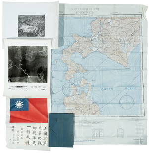
Sold2020Group Collections of Photography,Letters and MapsGroup collections of Japanese occupied Nanking in World War II. 2 military maps. 2 photography album included 293 pieces photos . One Japanese Bowl.See Sold Price
Sold2023WWII German Invasion of England 2nd Ed. MapsWorld War 2 german military plan maps of london, england invasion. 2nd edition, 1941. Includes 5 maps and folder. All maps are in tact, some yellowing and minor wear to fold creases due to age.See Sold Price
Sold2017Framed "Campaigns of the Super Sixth Armored Division"Framed "Campaigns of the Super Sixth Armored Division" historical 1945 WWII colored map, in an antique Victorian walnut frame with gilt liner, 18-1/2" x 38-3/4" overallSee Sold Price
Sold2022WWII fighter pilot maps and kitHeading: (World War II) Author: Title: Fighter pilot materials from World War II Place Published: Publisher: Date Published: c.1943-1945 Description: 1 set. Includes:See Sold Price
Sold2022US DEPARTMENT OF DEFENSE. WORLD WAR 2, SUMATRA, INDONESIA AND DUTCH EAST INDIES MAPS (1944-1946)US DEPARTMENT OF DEFENSE. WORLD WAR 2, SUMATRA, INDONESIA AND DUTCH EAST INDIES MAPS (1944-1946). US Army Map Service. Eight maps from Dutch Sumatra and Timor: Gle Jeueng (paper) and Lho'Nga (paper) eSee Sold Price
Sold2022US DEPARTMENT OF DEFENSE. WORLD WAR 2, SUMATRA, INDONESIA AND DUTCH EAST INDIES MAPS (1943-1946)US DEPARTMENT OF DEFENSE. WORLD WAR 2, SUMATRA, INDONESIA AND DUTCH EAST INDIES MAPS (1943-1946). US Army Map Service. Eight maps, from Dutch East Indies: Dutch Timor, Isle of Roti; Portuguese Timor;See Sold Price
Sold2018Normandy/Ile de France. World War 2 pre-D-Day militaryTITLE/CONTENT OF MAP: 'North west Europe. Rouen-Paris - Army/Air. Sheet 7' The map was published by the (British) War Office in 1943, with magnetic north dated to June 1943 - a year before the D-Day lSee Sold Price
Sold2024WORLD WAR 2 Japanese occupied Philippines Malaya Indochina Thailand 1942 mapTITLE/CONTENT OF MAP: 'Malaya, East Indies, Thailand and Indo-China' DATE PRINTED: 1942 IMAGE SIZE: Approx 22.5 x 27.5cm, 8.75 x 10.75 inches (Large) TYPE: Vintage colour map CONDITION: Good; suitableSee Sold Price
Sold2022World War 2. Western Europe 6 June 1944. Bomber Offensive/Overlord plan 1959 mapTITLE/CONTENT OF MAP: 'The War in Western Europe - The Combined Bomber Offensive - Overlord, High Command and Plan - German Dispositions, D-Day, 6 June 1944' DATE PRINTED: 1959 IMAGE SIZE: Approx 25.0See Sold Price
Sold2023WORLD WAR 2. Maginot & Siegfried line defences. Pre-invasion of France 1940 mapTitle: WORLD WAR 2. Maginot & Siegfried line defences. Pre-invasion of France 1940 map Description: Western Front showing forests and main defences: Section 1' by George Philip & Son (March 1940). VinSee Sold Price
Sold2022WORLD WAR 2. Maginot & Siegfried lines defences. Pre-invasion. Belgium 1940 mapTITLE/CONTENT OF MAP: 'Western Front showing forests and main defences: Section 2' DATE PRINTED: March 1940 IMAGE SIZE: Approx 26.5 x 42.0cm, 10.25 x 16.5 inches (Large) TYPE: Vintage colour map; ScalSee Sold Price
Sold2023WORLD WAR 2. Maginot & Siegfried lines defences. Pre-invasion. Belgium 1940 mapTitle: WORLD WAR 2. Maginot & Siegfried lines defences. Pre-invasion. Belgium 1940 map Description: Western Front showing forests and main defences: Section 2' by George Philip & Son (March 1940). VinSee Sold Price
Sold2023World War 2. Eastern Front. 16 April-7 May 1945. Final Russian Campaign 1959 mapTITLE/CONTENT OF MAP: 'The War in Eastern Europe - Final Russian Campaign in Central Europe - Operations, 16 April-7 May 1945' DATE PRINTED: 1959 IMAGE SIZE: Approx 25.0 x 33.5cm, 9.75 x 13 inches (LaSee Sold Price
Sold2024World War 2. Opening Japanese Offensive 1941. Pearl Harbor Malaya 1959 old mapTITLE/CONTENT OF MAP: 'The War with Japan - Opening Operations of Japanese Offensive' DATE PRINTED: 1959 IMAGE SIZE: Approx 25.0 x 32.5cm, 10 x 12.75 inches (Large) TYPE: Antique colour military map CSee Sold Price
Sold2024World War 2. Planned expansion of Japanese Empire 1959 old vintage map chartCAPTION PRINTED BELOW PICTURE: 'The War with Japan - Contemplated Expansion of Japanese Empire' DATE PRINTED: 1959 IMAGE SIZE: Approx 25.0 x 32.0cm, 9.75 x 12.75 inches (Large) TYPE: Antique colour miSee Sold Price
1 day LeftRapid Estate Liquidators and Auction Gallery6 1980s 1990s National Geographic Magazines A$35
Jun 12Dan Morphy AuctionsLOT OF 2 MAPS: LANDS IN THE COUNTIES OF RUNNELS & TOM GREEN RUNNELS COUNTY TEXAS MAPS.$200
2 days LeftEagles Corps International LLCOriginal lot of 1943 Comet Authenticast One-Inch scale model tanks of the world$22(3 bids)
6 days LeftChampagne AuctionsWORLD 1925-1976 Interesting Ephemera of a Well Travelled Military ManCA$30
6 days LeftJasper521733 BIBLE OLD TESTAMENT COMMENTARY by CALMET VELLUM FOLIO antique w/ LARGE MAP$160
May 30NY Elizabeth 1792 OLD INDIA HISTORY ANTIQUE ILLUSTRATED WITH MAPS OF THE EIGHTEENTH CENTURY IN FRENCH$50
6 days LeftJasper521903 HISTORY of FRENCH INTERVENTION in MEXICO KAISER MAXIMILLIAN antique 2 VOLS$130
6 days LeftJasper521792 ANCIENT HISTORY of INDIA antique ILLUSTRATED w/ MAPS 18th CENTURY in FRENCH$170
May 30Forum AuctionsItaly.- Rizzi-Zannoni (Giovanni Antonio) [Atlante Geografico del Regno di Napoli], c.1788-1812£500
7 days LeftJasper52BRAZIL & THE GUIANAS.Dutch French British Guiana(Guyana).Rio de Janeiro 1901 map$8
6 days LeftJasper521890 IN DARKEST AFRICA by HENRY M. STANLEY antique 2 VOLUMES illustrated w/ maps$75(1 bid)
6 days LeftJasper521868 TRAVELS in EAST INDIAN ARCHIPELAG0 by ALBERT BICKMORE illustrated ANTIQUE$170
2 hrs LeftForum AuctionsChina.- Audemard (L.) Les Jonques Chinoises, vol. I-VI (of X), first edition, 1957-65; and 12 others£50
2 hrs LeftForum AuctionsRussia.- Peter the Great.- Uystryalov (Nikolai) Karty, Plany I Snimki K Pervym Trem Tomam£750
6 days LeftThe Bidder AuctionsOrig. Press Photo of Josip Broz Tito PM and president of the Socialist Federal Republic of$35


![Italy.- Rizzi-Zannoni (Giovanni Antonio) [Atlante Geografico del Regno di Napoli], c.1788-1812 (1 of 2)](https://p1.liveauctioneers.com/5458/329231/177514979_1_x.jpg?height=282&quality=70&version=1715269091)


