Sold20242 - Lunar Maps of "Rima Bode II" - Photomap/Topographic MapsThese are two NASA Lunar Maps of "Rima Bode II" site location. These are Orbiter V Site 29 maps. They are of the same site location with one being a glossy Photomap dated 1969 and the other being a paSee Sold Price
Sold20242 - Lunar Topographic Maps "Rima Hadley" Color/Black & White MapsThese are two NASA Lunar Topographic Photomaps of "Rima Hadley" site location. These are Orbiter V Site 26.1 maps. They are of the same site location with one being in color dated 1970 and the other iSee Sold Price
20182 World War II maps2 World War II maps. Pacific and European Theater. Title: 2 World War II map. Framed. Medium: Print. Size: 9.5 X 7.5See Sold Price
Sold2021World War II Pictorial Battle Maps (2)VII Corps. With XIX Corps in Action From Secured Line to Victory. 2 WWII European theater maps, American troops and allies, movements with illustrations. Sights 20 1/2" x 27 1/2", overall 22" x 29".See Sold Price
Sold2020Group Collections of Photography,Letters and MapsGroup collections of Japanese occupied Nanking in World War II. 2 military maps. 2 photography album included 293 pieces photos . One Japanese Bowl.See Sold Price
Sold2022Problems of Greater BritainFIRST EDITION. Half-leather over marbled boards. Gilt titles to spine. Colour page block. Sporadic foxing. Volume I. x, [2], 596 pages. 4 fold-out colour maps. Volume II. [4], 618 pages. 1 fold-out coSee Sold Price
Sold2016Misc 1930's Era AdvertisingMisc 1930's Era advertising including: (9) Life Buoy wash up charts, Gas Station maps including: (2) Esso war map roman numeral II, (2) Sunoco war maps, (3) Air Craft Identification booksSee Sold Price
Sold2022A Handbook for Travellers in SpainOriginal navy rexine covers with silver title to spine. Colour top page blocks. Continuous pagination. Volume I. xviii, [2], 481 pages. Frontispiece. 1 fold-out map. Volume II. viii, pages 483 to 1032See Sold Price
Sold2023World War II Pictorial MapLightning Strikes Twice, 78th Inf. Division, 1918 to 1945. Records movements of the division by arrows through parts of Germany. Sight 16" x 20", overall 17 1/2" x 21 1/2".See Sold Price
Sold2019World War II Philippine Campaign MapOffice of AC of S G-3, Eight Army 22 1/2" x 20" reproduced by 67th Engineer Topo Co., SWPA 1945See Sold Price
Sold2017SDUK: Three Antique Maps of Turkey in Europe, 1830Map: Turkey I, II and III Cartographer: Baldwin & Cradock, Society for the Diffusion of Useful Knowledge Place & Date: London / 1830/1852 Size: 15" x 12 1/2" (the largest of the three maps) Condition:See Sold Price
Sold2022Lowell Thomas War Map - World War TwoLowell Thomas War Map of the World Maps in color. Dated: Circa 1940 - 1944 Condition Report Average wear. Good plus. Subject References: MapsSee Sold Price
Sold2022Lunar Far Side Map 1st Edition 1967An oversized Lunar Far Side Map (LFC-2) dated August 1967 and produced to a 1:10,000,000 scale from the US Government Printing Office. It measures 23" x 29". It has always been folded but it is in neaSee Sold Price
Sold2018Bellin: Lesser Antilles 2-Guadeloupe to Martinique 1764Suite des Isles Antilles 2. Partie A beautifully colored and preserved exemplar of Part II of Bellin's detailed map of the Lesser Antilles, featuring Guadeloupe, Martinique, and the islands in betweenSee Sold Price
Sold2020AN ANTIQUE SURVEY MAP, "U.S. Coast Survey: PreliminaryAN ANTIQUE SURVEY MAP, "U.S. Coast Survey: Preliminary Sketch of Galveston Bay, Texas," SECOND EDITION, CIRCA 1852, lithograph on paper, map "I, No. 2," A.D. Bache, Superintendent, "Verified by I.I.See Sold Price
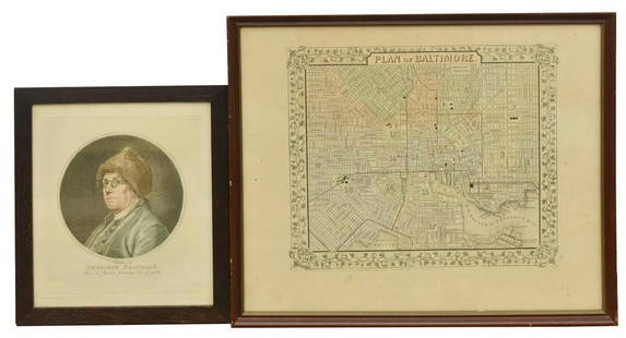
Sold2020(2) BEN FRANKLIN RUOTTE & BALTIMORE MAP ENGRAVINGS(lot of 2) Framed engravings on paper, including: (1) Benjamin Franklin (American, 1706-1790), after the original drawing by Charles Nicolas Cochin II (French, 1715-1790), engraved by C. Ruotte (LouisSee Sold Price
Sold2023Visscher Map of Middleburgh, HollandVISSCHER, Nicolas II (1649-1702). Untitled [Middelburgh] Engraved map with original hand color. Amsterdam, c.1690 21 1/2" x 24 3/8" sheet. Antique Map showing the then Island of Middleburgh in HollandSee Sold Price
Sold2020Latin Double Hemisphere Map in Bronze FrameDouble hemisphere map of the world by Henricus Hondius II (Dutch, 1597-1651), offset print, in a bronze frame. [Sight: 20 1/2 x 29 1/2 inches; Frame: 22 x 31 inches]. In good condition.See Sold Price
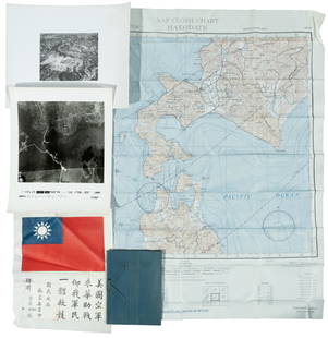
Sold2022WWII fighter pilot maps and kitHeading: (World War II) Author: Title: Fighter pilot materials from World War II Place Published: Publisher: Date Published: c.1943-1945 Description: 1 set. Includes:See Sold Price
Sold2020In Darkest Africa by Henry M. Stanley, Volume II, 1stIn Darkest Africa by Henry M. Stanley, Volume 2, First edition, published 1890 by Charles Scribners and Sons. Book includes steel engravins and maps inserted in pocked inside back cover.See Sold Price
Sold2023Three Piece Grouping of Hand Colored Engravings of Italian MapsThree Piece Grouping of Hand Colored Engravings of Italian Mapsto include, "Stato della Chiesa Dominium Ecclesasticum in Italia", 1636 by Henricus Hondius II (1597 - 1651 Dutch)16" x 20 1/2"Tabula ItaSee Sold Price
Sold2016JOHN W. HATCH (1919-1998) World War II"Map Reading" casein on paper 9 1/2 x 13 inches. unsigned, unframed. Note: The 29th Army Engineers were stationed in Portland, Oregon from 1942-1944 to provide combat troops with detail maps of AlaskaSee Sold Price
Sold2021(2) VOL. THE LAND AND THE BOOK, THOMSON, 1871Vol. I and II of The Land and The Book by W. M. Thomson, D.D. With maps and engravings. In two volumes. Published New York: Harper & Brothers, 1871. Partial leather bindings, marbled covers, marbled pSee Sold Price
Sold20171868-1869 NAVAL MAP OF THE NORTH PACIFIC OCEANMade up of Sheets I, II and III. (18) 13 x 13 inch sheets backed with cloth. 38 1/2 x 79 1/2 inches (to end of margins (overall))See Sold Price
1818 AuctioneersAntiquarian. Guyon, [Jeanne Marie] - The Life of Lady Guion, Written by herself in French, Now£22
Jun 02Schilb Antiquarian Rare Books1897 History of British Empire England Scotland Canada James II MAPS India 6v$3(2 bids)
5 days LeftHannam's Auctioneers LtdThe Complete Atlas of Modern, Classical and Celestial Maps, together with Plans of the Principal Cit£240


![Problems of Greater Britain: FIRST EDITION. Half-leather over marbled boards. Gilt titles to spine. Colour page block. Sporadic foxing. Volume I. x, [2], 596 pages. 4 fold-out colour maps. Volume II. [4], 618 pages. 1 fold-out co](https://p1.liveauctioneers.com/5584/242941/125949711_1_x.jpg?height=310&quality=70&version=1649192648)

![A Handbook for Travellers in Spain: Original navy rexine covers with silver title to spine. Colour top page blocks. Continuous pagination. Volume I. xviii, [2], 481 pages. Frontispiece. 1 fold-out map. Volume II. viii, pages 483 to 1032](https://p1.liveauctioneers.com/5584/235414/121908086_1_x.jpg?height=310&quality=70&version=1643755752)


![Visscher Map of Middleburgh, Holland: VISSCHER, Nicolas II (1649-1702). Untitled [Middelburgh] Engraved map with original hand color. Amsterdam, c.1690 21 1/2" x 24 3/8" sheet. Antique Map showing the then Island of Middleburgh in Holland](https://p1.liveauctioneers.com/1968/297676/158406682_1_x.jpg?height=310&quality=70&version=1690906360)
![Latin Double Hemisphere Map in Bronze Frame: Double hemisphere map of the world by Henricus Hondius II (Dutch, 1597-1651), offset print, in a bronze frame. [Sight: 20 1/2 x 29 1/2 inches; Frame: 22 x 31 inches]. In good condition.](https://p1.liveauctioneers.com/1221/177486/89638020_1_x.jpg?height=310&quality=70&version=1599275200)


![Antiquarian. Guyon, [Jeanne Marie] - The Life of Lady Guion, Written by herself in French, Now (1 of 2)](https://p1.liveauctioneers.com/8084/327245/177443504_1_x.jpg?height=282&quality=70&version=1715674059)


