Sold20232 ANTIQUE ITALIA MAPS GOTHA JUSTUS PERTHES2 Antique Maps from a19th c Atlas by Johan Georg Justus Perthes (1749-1812). Italia Superior and Italia Inferior.. Both professionally framed measures each 24"x21"x1" Weight combined 10 pds. PROVENANCSee Sold Price
Sold20182 Maps incl: Rudolf Gross. Karte Der Schweiz. 1865[Pocket Maps] 2 Maps. ++ Dr. A. Petermann’s Karte Von Europa Und Dem Mittellandischen Meere. Gotha: Justus Perthes, 1867. 16 sections on orig linen backing, each 10 1/2 x 8 1/2 in. Loose as issued iSee Sold Price
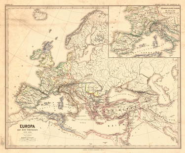
Sold2018Menke: Antique Map of Europe at time of OdovacarsTitle/Content of Map: Europa Zur Zeit Odovacars (476-493.) Date Printed: 1874 Cartographer: MENKE, TH. Publisher: JUSTUS PERTHES 1874 GOTHA Size: Quarto – 12.80 H x 15.75 W Inches "Von Th. Menke..."See Sold Price
Sold2017Perthes: Stieler's Antique School Atlas with Maps, 1865Map: Stieler's Schul-Atlas Uber Alle Theile Der Erde Cartographer: Stieler / J. Perthes Place & Date: Gotha / 1865 Size: 12" x 9 1/2" (each map) Condition: original outline color; overall age toning;See Sold Price
Sold2019Perthes: West Indies & Central AmericaMap Title: West-Indien und Centro-America. Cartographer: Justus Perthes Place / Date: Gotha / 1835/c.1850 Size: 9 5/8" x 7 1/2" Condition: Wash color; overall age toning, minor browning in margins A dSee Sold Price
Sold2023WORLD MAP GOTHA JUSTUS PERTHESWorld Map showing the Roman World at its peak with insets of the world in Homers time (900 BC) from 19th c Atlas by Johan Georg Justus Perthes (1749-1812). Some foxing to top of map. Professionally frSee Sold Price
Sold2017Petermann: Antique Map of Europe, 1881Map: Europa Publication Date: 1881 Authors: JUSTUS PERTHES, PETERMANN, A. | HABENICHT, H. Publisher: JUSTUS PERTHES Size: Folio – 13.00 H x 16.00 W Inches Im Maasstab von 1:15.000.000. From: AdSee Sold Price
Sold2018Antique Map Ost-Indien, 1870Title/Content of Map: Ost-Indien Cartographer: STULPNAGEL, F. VON/H. BERGHAUS Size: 12.25X15.75 From: Handatlas uber alle Theile der Erde und uber das Weltgebaude. Adolf Stieler, Gotha: Justus PerthesSee Sold Price
Sold2020Stieler, Adolph 1905 Pair Maps Celestial Constellations"Der Nordliche Sternhimmel" and "Der Sudliche Sternhimmel" North and Southern Constellations. Lithograph Maps Published 1905 by Justus Perthes, Gotha for "Stielers Hand-Atlas" by Adolf Stieler. CentreSee Sold Price
Sold2020Stieler, Adolph 1905 Pair of Maps. East Indies"Ostindische Inseln" and "Hinter-Indien und Archipel" Lithograph Maps Published 1905 by Justus Perthes, Gotha for "Stielers Hand-Atlas" by Adolf Stieler. Centre fold as published. Paper Size: 18.5 x 1See Sold Price
Sold2020Stieler, Adolph 1905 Lot of 7 Maps of RussiaLithograph Maps Published 1905 by Justus Perthes, Gotha for "Stielers Hand-Atlas" by Adolf Stieler. Centre fold as published. Paper Size: 18.5 x 15.5 inch (48 x 40cm) Good ConditionSee Sold Price
Sold2020Stieler, Adolph 1905 Pair of Maps of North & South Pole"Nord-Polar Karte" and "Sud-Polar Karte" Lithograph Maps Published 1905 by Justus Perthes, Gotha for "Stielers Hand-Atlas" by Adolf Stieler. Centre fold as published. Paper Size: 18.5 x 15.5 inch (48See Sold Price
Sold2020Stieler, Adolph 1905 Lot of 5 Maps. AustraliaLithograph Maps Published 1905 by Justus Perthes, Gotha for "Stielers Hand-Atlas" by Adolf Stieler. Centre fold as published. Paper Size: 18.5 x 15.5 inch (48 x 40cm) Good ConditionSee Sold Price
Sold2020Stieler, Adolph 1905 Lot of 5 Maps. Spain & PortugalLithograph Maps Published 1905 by Justus Perthes, Gotha for "Stielers Hand-Atlas" by Adolf Stieler. Centre fold as published. Paper Size: 18.5 x 15.5 inch (48 x 40cm) Good ConditionSee Sold Price
Sold2020West Indies Caribbean 1903-05 Pair of MapsLithograph Maps Published 1905 by Justus Perthes, Gotha for "Stielers Hand-Atlas" by Adolf Stieler and 1903 by Adam & Charles Black, Edinburgh & London for "Encyclopaedia Brittannica" Tenth Edition CeSee Sold Price
Sold2021Stieler, Adolph 1905 Lot 7 Maps Austria Germany HungaryLithograph Maps Published 1905 by Justus Perthes, Gotha for "Stielers Hand-Atlas" by Adolf Stieler. Centre fold as published. Paper Size: 18.5 x 15.5 inch (48 x 40cm) One map split in two. OccasionalSee Sold Price
Sold2020Stieler, Adolph 1905 Lot of 4 Maps. UK & IrelandLithograph Maps Published 1905 by Justus Perthes, Gotha for "Stielers Hand-Atlas" by Adolf Stieler. Centre fold as published. Paper Size: 18.5 x 15.5 inch (48 x 40cm) Good ConditionSee Sold Price
Sold2020Stieler, Adolph 1905 Lot 4 Maps of the USA, N. AmericaIncl North America Continent, and 3 others showing parts of the USA, one showing part of Texas. Lithograph Maps Published 1905 by Justus Perthes, Gotha for "Stielers Hand-Atlas" by Adolf Stieler. CentSee Sold Price
Sold2020Stieler, Adolph 1905 Lot 6 Maps South America & MexicoIncl Mexico, South America Continent, and several sheets showing parts of South America. Lithograph Maps Published 1905 by Justus Perthes, Gotha for "Stielers Hand-Atlas" by Adolf Stieler. Centre foldSee Sold Price
Sold2020Stieler, Adolph 1905 Lot of 5 Maps of ItalyLithograph Maps Published 1905 by Justus Perthes, Gotha for "Stielers Hand-Atlas" by Adolf Stieler. Centre fold as published. Paper Size: 18.5 x 15.5 inch (48 x 40cm) A few margin tears, images fineSee Sold Price
Sold2020Stieler, Adolph 1905 Lot of 5 Maps of Greece & BalkansLithograph Maps Published 1905 by Justus Perthes, Gotha for "Stielers Hand-Atlas" by Adolf Stieler. Centre fold as published. Paper Size: 18.5 x 15.5 inch (48 x 40cm) Good ConditionSee Sold Price
Sold2020Stieler, Adolph 1905 Lot of 6 Maps of AfricaNorth and South Africa, plus Madagascar. Lithograph Maps Published 1905 by Justus Perthes, Gotha for "Stielers Hand-Atlas" by Adolf Stieler. Centre fold as published. Paper Size: 18.5 x 15.5 inch (48See Sold Price
Sold2020Stieler, Adolph 1905 Map of the World Hemispheres"Westliche und Ostliche Halbkugel" Lithograph Map Published 1905 by Justus Perthes, Gotha for "Stielers Hand-Atlas" by Adolf Stieler. Centre fold as published. Paper Size: 18.5 x 15.5 inch (48 x 40cm)See Sold Price
Sold2020Stieler, Adolph 1905 Map World on Mercator's Projection"Weltkarte in Mercators Projection" Lithograph Map Published 1905 by Justus Perthes, Gotha for "Stielers Hand-Atlas" by Adolf Stieler. Centre fold as published. Paper Size: 18.5 x 15.5 inch (48 x 40cmSee Sold Price
3 days LeftAlbion AuctionsStieler, Adolf 1909 Antique Map. New Zealand - South Sea Islands, Pacific Australia Hawaii$5
3 days LeftTrillium Antique Prints & Rare BooksGoubaud - 4 Lithographs of Fashionably Dressed Women$75
20 hrs LeftJasper52WORLD WAR 2. English Channel & North sea ports. German occupied Europe 1942 map$30
20 hrs LeftJasper52WORLD WAR 2. Siegfried & Maginot lines defences. Pre-invasion. Belgium 1940 map$25
20 hrs LeftJasper52WORLD WAR 2. Siegfried & Maginot line defences. Pre-invasion of France 1940 map$30
20 hrs LeftJasper52WORLD WAR 2. Netherlands & Belgium defences. Siegfried & Maginot lines 1940 map$35


![2 Maps incl: Rudolf Gross. Karte Der Schweiz. 1865: [Pocket Maps] 2 Maps. ++ Dr. A. Petermann’s Karte Von Europa Und Dem Mittellandischen Meere. Gotha: Justus Perthes, 1867. 16 sections on orig linen backing, each 10 1/2 x 8 1/2 in. Loose as issued i](https://p1.liveauctioneers.com/179/117971/60557787_1_x.jpg?height=310&quality=70&version=1520636872)