Sold202319th C. Philadelphia Visitor's MapA "Philadelphia Visitor's Companion" featuring a map of the city of Philadelphia, compiled by Thomas Morrison, circa 1834. Mat opening: 17in x 21-1/2in. Frame: 24in x 27-1/2in. | Local and NYC curbsidSee Sold Price
Sold2023Two Rolling maps of PennsylvaniaTwo 19th c. maps of Pennsylvania, includes 1894 map of Philadelphia, and 1852 map of the Township of Lower Merrion, Montgomery County, Pennsylvania. 1852 map is missing the top half. Some creasing, teSee Sold Price
Sold202219th c Paper & Pamphlets including VT19th c paper and pamphlets including Vermont fairs, 1847 Danvers school regulations, 1876 Centennial Exhibition visitor's guide with fold-out map, etcSee Sold Price
Sold202419th C. Thomas Holme Province of Pennsylvania MapA 19th C. facsimile map of a 1681 issued map titled "A Map of the Improved Part of the Province of Pennsilvania in America". Includes a note from a Philadelphia print shop. Frame opening: 34in x 56-1/See Sold Price
Sold2022Atlas of PhiladelphiaAtlas of Philadelphia, "South St to Lehigh Ave", colored maps with linen backed pages, 19th 20th C, 18" x 23". CONDITION: Fair, binding separation with tape, wear and corner fold; street directory pagSee Sold Price
Sold2022Early Nineteenth Century Map of Texas.Early 19th century hand colored map of Texas published by C.S. Williams, NE Corner of Market and 7th St., Philadelphia, 1845. Map engraved by J.H. Young exhibits previous folds and has been laid down.See Sold Price
Sold2017MICHEL CHEVALIER (FRENCH, 19TH CENTURY) MAP OF THE C &MICHEL CHEVALIER (FRENCH, 19TH CENTURY) MAP OF THE C & O CANAL lithograph on paper, "Plan Topographique Du Terrain Traverse Par Le Canal de la Chesapeake a l'Ohio", with inset plan of Philadelphia, frSee Sold Price
Sold2023Antique 19th C. Map of East Los Angeles CountyAntique 19th Century panoramic map of East Los Angeles County, California, depicting a bird's-eye view from Los Angeles River looking towards the Sierra Madre Mountains. Printed by H.S. Crocker & Co.,See Sold Price
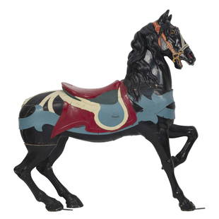
Sold2023GUSTAVE DENTZEL CAROUSEL FIGURE OF A STANDING HORSE Late 19th Century, Philadelphia, PennsylvaniaGUSTAVE DENTZEL CAROUSEL FIGURE OF A STANDING HORSELate 19th Century, Philadelphia, PennsylvaniaHead not attached.Height 65”.See Sold Price
Sold202119th Century Map of MemphisPLAN DE LA VILLE DE MEMPHIS (ETATS-UNIS) 40,000 HABITANTS pen and ink with watercolor hand drawn drainage system map, circa 1870. Depicts a grid street plan of the city of Memphis with labeled streetSee Sold Price
Sold202119th C Philadelphia Sewing TableThis is a 19th Century (c 1800 - 1825) Philadelphia sewing table. A similar, almost identical, table can be found in the Philadelphia Museum of Art, bequeathed by Caroline D. Bache (according to articSee Sold Price
Sold202319th C Philadelphia Dowry Chest Mary Gibson HenryPhiladelphia wooden inlaid walnut dowry / hope chest / document box approx 20.5" W x 12.5" D x 11" H with mitered dovetail corners. Has 18th century snipe wire hinges, used back as early as the 18th cSee Sold Price
Sold202119TH C. MAP OF NEW YORK & BROOKLYN (TEAR)19TH C. MAP OF NEW YORK & BROOKLYN (TEAR) 25.5" X 40"See Sold Price
Sold202119th c. Philadelphia Windsor ChairEarly 19th c. Philadelphia Windsor chair. Probably John B. Ackerley. 18 1/2" seat Ht., 38 1/2" overall Ht..See Sold Price
Sold2023Pair 19th C Philadelphia Cast Iron Gate PostsA pair of late 19th century Philadelphia cast iron gate/ entrance post each having a finial top supported on a chamfered post. Size: longest 72" H x 9" square at widest point.See Sold Price
Sold202119th C. Map of Indian Territory & 20th C. Kachina**Originally Listed At $300** Map: "Map of Indian Territory Drawn and Engraved on Copper Plate Expressly for Johnson's Cyclopedia" - Volume IV New York - A.J. Johnson Company, ca. 1880 to 1894. FigureSee Sold Price
Sold2023LATE 19TH C. PHILADELPHIA CHILDS PINE DESK, SIGNEDAmerican dark stained pine child's desk, late 19th century, having a rectangular top over a short drawer and raised on tapered legs, pencil inscription to interior of drawer "...Phila, Pa, about 1871See Sold Price
Sold202219th C. Map of New YorkMap of New York dated 1890, showing political divisions and subdivisions November 1870, gilt framed under glass. [Art: 17" H x 38" W; Frame: 25 1/2" H x 47" W]. In good condition.See Sold Price
Sold2018(2) Late 19th c. maps of Ireland, unframedTwo late 19th century colored maps of Ireland, comprising a map of Ireland printed for The Century Atlas, circa 1897, 16"h x 11"w, unframed, and a map of Ireland printed for The Society for the DiffusSee Sold Price
Sold202218th & 19th C. MAPS OF ASIA (3 MAPS)Includes: 2 maps by John Tallis & Co. London / New York, ca. 1850, both matted and framed, including: (1) MAP OF ASIA. Hand colored engraved map. 5 hand colored vignettes. H. 10.25", W. 12.75"; (2) MASee Sold Price
Sold2017Original 19th C. Map of BostonOriginal 19th C. Map of Boston, framed. Image size: 7 x 4 inches.See Sold Price
Sold202219th C Maps Isles of Shoals, Portsmouth NHPortsmouth NH maps, Dated 1816 Plan of Portsmouth Harbour published by Edmund M. Blunt NY 4.5" x 7.5". Dated 1841 hand colored map of the Isles of Shoals published by E & GW Blunt NY. 8.5" x 10.25".See Sold Price
Sold2015Lg Framed early 19th c. Map of the WorldLg Framed early 19th c. Map of the World, "Mappe Monde", Indication des trois voyages du Capitaine Cook, French 1816 in floral gilt 32" x 46" frame Condition; was folded, some wear along fold lines frSee Sold Price
1 hr LeftPotter & Potter AuctionsBOLLMANN, Hermann (1911 – 1971). Map of New York City. 1962.$100
3 days LeftLocati, LLCStaffordshire Historical Blue-Transfer Decorated Platter: Pennsylvania Hospital$125
5 days LeftJasper521798 BIBLE FIRST HOT PRESS EDITION LARGE FOLIO antique AMERICANA 18th cent. RARE$800
5 days LeftJasper521797 HISTORY OF VOYAGE TO COAST of AFRICA by JOSEPH HAWKINS antique 1st EDITION$600


![19th C. Map of New York: Map of New York dated 1890, showing political divisions and subdivisions November 1870, gilt framed under glass. [Art: 17" H x 38" W; Frame: 25 1/2" H x 47" W]. In good condition.](https://p1.liveauctioneers.com/1221/251963/131695197_1_x.jpg?height=310&quality=70&version=1656475639)


