Sold202219TH C. BYRRH FRENCH CYCLISTS MAPLate 19th c.-1900's small bound cyclists map of the southwest of France. Published as publicity for Byrrh. Dimensions: H 4.75" x W 3.5" x D .5" Condition: As is; binding falling apart. Toning, tears,See Sold Price
Sold201919th C. French Map - The Port of Vera Cruz Mexico100% of the Hammer price of all lots sold in this auction will be donated to Community Food Share by Artemis Gallery. $1.00 = 3 meals! **First Time At Auction** Europe, France, ca. 19th century CE.See Sold Price
Sold2017Antique 19th C French Hand Colored Map of AriegeAntique 19th C French Hand Colored Map of Ariege. Hand colored well detailed engraving showing the French department of Ariege with scenes of regional trade, products and life along with a coat of armSee Sold Price
Sold2017Antique 19th C French Hand Colored Map of CalvadosAntique 19th C map of the French area of Calvados. This area of France is known for its production of Calvados. The engraving is surrounded by scenes showing the region and its products. Published bySee Sold Price
Sold20231850s Dufour ATLAS 42 HUGE MAPS Europe ENORMOUS & RARE Geography Cartography1850s Dufour ATLAS 42 HUGE MAPS Europe ENORMOUS & RARE Geography Cartography Adolphe Dufour was a 19th-century French cartographer and map maker known for his highly detailed maps of European cities aSee Sold Price
Sold2017MICHEL CHEVALIER (FRENCH, 19TH CENTURY) MAP OF THE C &MICHEL CHEVALIER (FRENCH, 19TH CENTURY) MAP OF THE C & O CANAL lithograph on paper, "Plan Topographique Du Terrain Traverse Par Le Canal de la Chesapeake a l'Ohio", with inset plan of Philadelphia, frSee Sold Price
Sold201619th C French set of 3 engraving maps19th C French set of 3 engraving maps. 14” H x 20” W. Shipping in USA is $ 50.00. International bidders ask for shipping before bid.See Sold Price
Sold20191844 Pacific Voyages D’Urville Australia MAP Magellan1844 Pacific Voyages D’Urville Australia MAP Magellan Cook Anson Vancouver MAPS Jules Dumont D’Urville was a 19th-century French explorer who is best known for his voyages in the South Pacific andSee Sold Price
Sold20171848 1st ed French ATLAS 95 Maps France Colonies1848 1st ed French ATLAS 95 Maps France Colonies Brittany Herault Illustrated A rare 19th-century French atlas published by Migeon and collected by Vuillemin. Each of these extremely desirable engraviSee Sold Price
20181835 ATLAS MAPS Cartography Navigation Voyages1835 ATLAS MAPS Cartography Navigation Voyages Illustrated Monin French Petit Charles V. Monin was a 19th-century French cartographer who was one of the first Europeans to print maps under the printinSee Sold Price
Sold20181835 EXQUISITE French ATLAS Cartography MAPS Navigation1835 EXQUISITE French ATLAS Cartography MAPS Navigation Voyages Illustrated Monin Charles V. Monin was a 19th-century French cartographer who was one of the first Europeans to print maps under the priSee Sold Price
Sold2024*19TH C. FRENCH MUSICAL BICYCLIST TOYLikely French, circa 1898. Keywind polychromed tin toy with early hand-painted cyclist figure in white cap and striped jersey connected to a tiered round base. When wound, the cyclist travels around tSee Sold Price
Sold2022(2) FRENCH 19TH C. ATLAS NATIONALE ILLUSTRE MAPSFor the departments of Gironde and Vienne. Lithographs with light hand-coloring. Dimensions: (Frame) H 22.25" x W 15.5" Condition: Slight age toning to paper.See Sold Price
Sold2022(2) FRENCH 19TH C. ATLAS NATIONALE ILLUSTRE MAPSDepartments of Lyonne and Cers. Lithographs with light hand-coloring. Dimensions: (Frame) H 15.5" x W 22.25" Condition: Slight age toning to paper.See Sold Price
Sold20191830 D’Urville Pacific Voyages Illustrations Australia1830 D’Urville Pacific Voyages Illustrations Australia Tahiti MAPS Hawaii Jules Dumont D’Urville was a 19th-century French explorer who is best known for his voyages in the South Pacific and AntarSee Sold Price
Sold20211855 1ed Napoleon Bonaparte WARS French Revolution1855 1ed Napoleon Bonaparte WARS French Revolution Illustrated Maps 2v Abbott John S.C. Abbott was a 19th-century American historian who wrote works on a variety of topics including the French RevolutSee Sold Price
Sold2020Three maps, late 18th-early 19th centuryThree mapslate 18th-early 19th centuryComprising a French hand-colored copperplate map of Virginia, 1760-1762; a map of the United States, 1719, by H.A. Chatelain, Amsterdam; and a map of Delaware, 18See Sold Price
Sold2019Judaica Biblical print David Mourning for Absalom byBiblical print "David Mourning for Absalom", by Gustave Doré, c.19th Century; image size: 19.85 x 24.6cm. Top-left corner damaged. Product Tags: French, Holylandish Artwork/Prints, Maps, Prints & ArtSee Sold Price
Sold2019Judaica Biblical print Solomon by Gustave Doré, c.19thBiblical print "Solomon", by Gustave Doré, c.19th Century; image size: 19.8 x 24.45cm. Spill stain at top left corner. Product Tags: French, Holylandish Artwork/Prints, Maps, Prints & Artwork and JudSee Sold Price
Sold2016World Map in Hemispheres 19th CMap: Mapemonde. (World map in hemispheres) Maker: Unknown Origin: French, 19th Century Medium: Original lithograph with hand coloring. Sheet Size: 6 1/4 x 9 inches No Reserve: This lot starts at $1 anSee Sold Price
Sold2024AMERICAN FRENCH AND INDIAN WAR COMMEMORATIVE POWDER HORNAMERICAN FRENCH AND INDIAN WAR COMMEMORATIVE POWDER HORN 19TH CENTURY engraved ?PETER MYER, HISS HORN, ANO 1759? as well as the British coat of arms, and a map of the forts in the Hudson and Mohawk vaSee Sold Price
Sold2022French jigsaw puzzle by Auguste Logerot full set 19th Century Fremin geographerLogerot made use of the works of the well known cartographers Fremin, Dufour, Dyonnet, and Vuillemin. He published map, atlases, folding case maps and jigsaw puzzle maps. He was active at Quai des AugSee Sold Price
Sold20191920's 7.5" ANTIQUE FRENCH TERRESTRIAL GLOBE ForestThis 9 inches French globe is a "forest " with an address in Paris , 44 rue des Champs , this company was a School supply and a map editor company during the 19th. century which disappeared in the earSee Sold Price
6 days LeftWorthington GalleriesAntique H/C Map EUROPE SOUS CHARLEMAGNE EN 814: EMPIRES D'OCCIDENT ET D'ORIENT$25
Featured2 days LeftJasper52COLONIES FRANÇAISES en AFRIQUE. Africa Sénégal Madagascar. LEVASSEUR c1850 map$65
1 day LeftJasper521641 MAP of ITALY antique authentic TERRITORIUM BONONIENSE IL BOLOGNESE original$160
4 days LeftFive Star AuctionsDavid & Goliath, Large 19th C. French Barbedienne Bronze Sculpture, Antonin Mercie Signed$8,000
4 days LeftFive Star Auctions19th C. French Orientalist Baccarat Crystal Figural Bronze Centerpiece$4,500
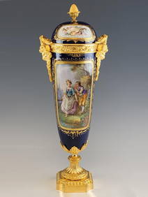
4 days LeftFive Star Auctions19th C. French Baccarat Crystal Figural Champleve enamel Bronze Centerpiece$6,000