Sold20201938 R Taylor White Pictorial Map of North Carolina --Title: 1938 R Taylor White Pictorial Map of North Carolina -- North Carolina Date: 1938, Boston Cartographer: Ruth Taylor White Size: 11.6 x 8.5 in. Additional Information: This is Ruth Taylor White'sSee Sold Price
Sold20211938 R Taylor White Pictorial Map of North Dakota --Title: 1938 R Taylor White Pictorial Map of North Dakota -- North Dakota Cartographer: Ruth Taylor White Year / Place: 1938, Boston Map Dimension (in.): 11.6 x 8.5 in. This is Ruth Taylor White's charSee Sold Price
Sold20211938 R Taylor White Pictorial Map of South Carolina --Title: 1938 R Taylor White Pictorial Map of South Carolina -- South Carolina Cartographer: Ruth Taylor White Year / Place: 1938, Boston Map Dimension (in.): 11.6 x 8.5 in. This is Ruth Taylor White'sSee Sold Price
Sold20221938 R Taylor White Pictorial Map of South Carolina -- South CarolinaTitle: 1938 R Taylor White Pictorial Map of South Carolina -- South Carolina Cartographer: Ruth Taylor White Year / Place: 1938, Boston Map Dimension (in.): 11.6 x 8.5 in. This is Ruth Taylor White'sSee Sold Price
Sold20181938 R Taylor White Pictorial Map of CaliforniaTitle/Content of Map: 1938 R Taylor White Pictorial Map of California -- California Date Printed: 1938, Boston Cartographer: Ruth Taylor White Size: 11.6 x 8.5 in. This is Ruth Taylor White's charmingSee Sold Price
Sold20181938 R Taylor White Pictorial Map of Florida -- FloridaTitle/Content of Map: 1938 R Taylor White Pictorial Map of Florida -- Florida Date: 1938, Boston Cartographer: Ruth Taylor White Size: 11.6 x 8.5 in. This is Ruth Taylor White's charming pictorial mapSee Sold Price
Sold20201938 R Taylor White Pictorial Map of Hawaii and SamoaTitle: 1938 R Taylor White Pictorial Map of Hawaii and Samoa -- Territory of Hawaii [with] Samoa Cartographer: Ruth Taylor White Year/Place: 1938, Boston Size: 11.6 x 8.5 in. Description: This is RuthSee Sold Price
Sold20181938 R Taylor White Pictorial Map of Hawaii and SamoaTitle/Content of Map: 1938 R Taylor White Pictorial Map of Hawaii and Samoa -- Territory of Hawaii [with] Samoa Date Printed: 1938, Boston Cartographer: Ruth Taylor White Size: 11.6 x 8.5 in. This isSee Sold Price
Sold20231938 R Taylor White Pictorial Map of Hawaii and Samoa -- Territory of Hawaii [with] SamoaTitle: 1938 R Taylor White Pictorial Map of Hawaii and Samoa -- Territory of Hawaii [with] Samoa Cartographer: Ruth Taylor White Year / Place: 1938, Boston Map Dimension (in.): 11.6 x 8.5 in. This isSee Sold Price
Sold20221938 R Taylor White Pictorial Map of Texas -- TexasTitle: 1938 R Taylor White Pictorial Map of Texas -- Texas Cartographer: Ruth Taylor White Year / Place: 1938, Boston Map Dimension (in.): 11.6 x 8.5 in. This is Ruth Taylor White's charming pictorialSee Sold Price
Sold20211938 R Taylor White Pictorial Map of Texas -- TexasTitle: 1938 R Taylor White Pictorial Map of Texas -- Texas Cartographer: Ruth Taylor White Year / Place: 1938, Boston Map Dimension (in.): 11.6 x 8.5 in. This is Ruth Taylor White's charming pictorialSee Sold Price
Sold20211938 R Taylor White Pictorial Map of the PhilippineTitle: 1938 R Taylor White Pictorial Map of the Philippine Islands -- Philippine Islands Cartographer: Ruth Taylor White Year / Place: 1938, Boston Map Dimension (in.): 11.6 x 8.5 in. This is Ruth TaySee Sold Price
Sold20181938 R Taylor White Pictorial Map of Colorado --Title/Content of Map: 1938 R Taylor White Pictorial Map of Colorado -- Colorado1938, Boston Cartographer: Ruth Taylor White Size: 8.5 11.6 in. This is Ruth Taylor White's charming pictorial map, or caSee Sold Price
Sold20181938 R Taylor White Pictorial Map of the PhilippineTitle/Content of Map: 1938 R Taylor White Pictorial Map of the Philippine Islands -- Philippine Islands Date Printed: 1938, Boston Cartographer: Ruth Taylor White Size: 11.6 x 8.5 in. This is Ruth TaySee Sold Price
Sold20181938 R Taylor White Pictorial Map of Kansas -- KansasTitle/Content of Map: 1938 R Taylor White Pictorial Map of Kansas -- Kansas Date: 1938, Boston Cartographer: Ruth Taylor White Size: 11.6 x 8.5 in. This is Ruth Taylor White's charming pictorial map,See Sold Price
Sold20181938 R Taylor White Pictorial Map of the Caribbean andTitle/Content of Map: 1938 R Taylor White Pictorial Map of the Caribbean and Central America -- This Map locates the Panama Canal Zone, Porto Rico and Virgin Islands in Central America and the West InSee Sold Price
Sold20201938 R Taylor White Pictorial Map of New Jersey -- NewTitle/Content of Map: 1938 R Taylor White Pictorial Map of New Jersey -- New Jersey Cartographer: Ruth Taylor White Year/Place: 1938, Boston Size: 11.6 x 8.5 in. This is Ruth Taylor White's charming pSee Sold Price
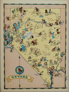
Sold20211938 R Taylor White Pictorial Map of Nevada -- NevadaTitle: 1938 R Taylor White Pictorial Map of Nevada -- Nevada Cartographer: Ruth Taylor White Year / Place: 1938, Boston Map Dimension (in.): 11.6 x 8.5 in. This is Ruth Taylor White's charming pictoriSee Sold Price
Sold20201938 R Taylor White Pictorial Map of Utah -- UtahTitle/Content of Map: 1938 R Taylor White Pictorial Map of Utah -- Utah Date: 1938, Boston Cartographer: Ruth Taylor White Size: 11.6 x 8.5 in. This is Ruth Taylor White's charming pictorial map, or cSee Sold Price
Sold20211938 R Taylor White Pictorial Map of Massachusetts --Title: 1938 R Taylor White Pictorial Map of Massachusetts -- Massachusetts Cartographer: Ruth Taylor White Year / Place: 1938, Boston Map Dimension (in.): 11.6 x 8.5 in. This is Ruth Taylor White's chSee Sold Price
Sold20201938 R Taylor White Pictorial Map of Georgia -- GeorgiaTitle/Content of Map: 1938 R Taylor White Pictorial Map of Georgia -- Georgia Cartographer: Ruth Taylor White Year/Place: 1938, Boston Size: 11.6 x 8.5 in. This is Ruth Taylor White's charming pictoriSee Sold Price
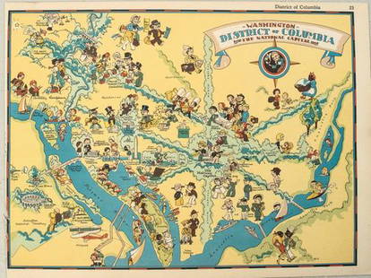
Sold20211938 R Taylor White Pictorial Map of Washington D.C. --Title: 1938 R Taylor White Pictorial Map of Washington D.C. -- Washington District of Columbia the National Capital Cartographer: Ruth Taylor White Year / Place: 1938, Boston Map Dimension (in.): 11.6See Sold Price
Sold20211938 R Taylor White Pictorial Map of the United StatesTitle: 1938 R Taylor White Pictorial Map of the United States -- The United States of America Cartographer: Ruth Taylor White Year / Place: 1938, Boston Map Dimension (in.): 11.6 x 8.5 in. This is RutSee Sold Price
Sold20191938 R Taylor White Pictorial Map of Michigan --Title/Content of Map: 1938 R Taylor White Pictorial Map of Michigan -- Michigan Date: 1938, Boston Cartographer: Ruth Taylor White Size: 11.6 x 8.5 in. This is Ruth Taylor White's charming pictorial mSee Sold Price
2 days LeftLeland LittleChristy Mathewson (Dark Cap) 1909-1911 T206 White Border (Piedmont Back), Tobacco Card$1,300(7 bids)
Jun 08Simpson Galleries, LLC.GERALD "G. HARVEY" JONES (American/Texas 1933-2017) A PAINTING, "Quiet Waters," 1983$3,000
4 days LeftTrillium Antique Prints & Rare BooksKarl Bodmer - "Dog Dance"; P?hriska-R?hpa. Moennitarri Warrior in the Costume of the Dog Danse$350(2 bids)
4 days LeftNorthgate Gallery, Inc.Late 20th C. Wright Table Company (North Carolina) Mahogany Dining Table$100
4 days LeftRbfineartsSigned Hand Crafted Pottery Swan Vessel From Cherokee, North Carolina$35(2 bids)
Jun 09Heartland Artifact Auctions Inc4 5/8" Archaic Notched Axe, Dickey COA, found in North Carolina$10(1 bid)


![1938 R Taylor White Pictorial Map of Hawaii and Samoa: Title: 1938 R Taylor White Pictorial Map of Hawaii and Samoa -- Territory of Hawaii [with] Samoa Cartographer: Ruth Taylor White Year/Place: 1938, Boston Size: 11.6 x 8.5 in. Description: This is Ruth](https://p1.liveauctioneers.com/5584/169916/85621317_1_x.jpg?height=310&quality=70&version=1591137604)
![1938 R Taylor White Pictorial Map of Hawaii and Samoa: Title/Content of Map: 1938 R Taylor White Pictorial Map of Hawaii and Samoa -- Territory of Hawaii [with] Samoa Date Printed: 1938, Boston Cartographer: Ruth Taylor White Size: 11.6 x 8.5 in. This is](https://p1.liveauctioneers.com/5584/117342/60336911_1_x.jpg?height=310&quality=70&version=1520389291)
![1938 R Taylor White Pictorial Map of Hawaii and Samoa -- Territory of Hawaii [with] Samoa: Title: 1938 R Taylor White Pictorial Map of Hawaii and Samoa -- Territory of Hawaii [with] Samoa Cartographer: Ruth Taylor White Year / Place: 1938, Boston Map Dimension (in.): 11.6 x 8.5 in. This is](https://p1.liveauctioneers.com/5584/274166/143946169_1_x.jpg?height=310&quality=70&version=1673389176)