Sold20241929 MAP OF NORTHERN MAINE AND CHART OF CASCO BAYMap is 36 inches by 33 inches and Chart is 45 inches by 35 inchesSee Sold Price
Sold2022George De Lyra Lunch Counter Drawing(Maine 1929-1999), ink stipple drawing on paper, signed “De Lyra” upper right and signed and titled on reverse, framed, 16 x 19 inches.See Sold Price
Sold20221888 FRONT DOOR YARD OF OUR COUNTRY MAINE CENTRAL RAILROAD BOOKHas multiple maps in the book. map of fishing and hunting resorts of Rangeley lakes region Parmachenee & seven ponds. map of mt desert island. map of Maine showing train routes of travel. damage tSee Sold Price
Sold2016Rare, 1890s Map of MaineRare map of Maine, “Freeport Sheet†by the US Geological survey from 1890. Shows islands and necks within Casco Bay as well as Freeport, Cumberland, Brunswick and surrounding towns. Matted aSee Sold Price
Sold2022Large Rare Map of Waterford Maine by Daniel Chaplin1850, hand colored, 37 x 29.5 inches, sight. Framed, wrinkles and limited splitting.See Sold Price
Sold202219th Century Chart of Northern New England and New France.A new Chart of the Coast of New England, Nova Scotia, New France or Canada, with the Islands of Newfoundland, Cape Breton and St. John’s.See Sold Price
Sold2021J. Chase 1856 Map of Kennebec County Maine.57 x 58 inches, losses to top of map, top bar partially detached. Philadelphia and Boston: J.L. Smith, 1856See Sold Price
Sold20221890 Township Map of the State of Maine.Published by G.W. & C.B. Colton, New York, 37 x 30.5 inches, sight. Beautifully framed, 45 x 39 inches.See Sold Price
Sold20221937 Romance Map of the State of MaineCopyright 1936 by Alice E. Fowler and Grace F. Dodge, Compilers, framed, 26 x 20.25 inches.See Sold Price
Sold2022Early 20th Century Maine Automobile Road Book.With fold out map, wear to cover.See Sold Price
Sold2021Seven Old Nautical Charts.Mostly Maine, largest 44 x 36 inches. Together with a crock, repaired crack.See Sold Price
Sold20231754 An Accurate Map Of the English Colonies in North America1754 An Accurate Map Of the English Colonies in North America bordering on the River Ohio, by John Hinton. Covers the Carolinas to the Great Lakes and Casco Bay off the coast of present-day Maine. PubSee Sold Price
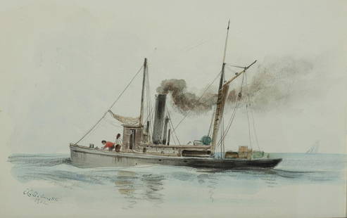
Sold2021Xanthus Russell Smith (Am. 1838-1929), Casco Bay...XANTHUS RUSSELL SMITH (Am. 1838-1929) Casco Bay Steamer, 1902 Pencil and watercolor on paper, framed under acrylic 6 1/2" x 10" actual, 10 3/8" x 13 7/8" framed Signed and dated l.l., "Wiscasset Bay GSee Sold Price
Sold2023400 - New England States Postcard AlbumExcludes Massachusetts - See Lot 121 for more Postcards. Portland, Maine, Casco Bay, Brunswick, Providence, RI, Newport, Narragansett, Pawtucket, Woonsocket, Hartford, CT, New Haven, Putnam, BurlingtoSee Sold Price
Sold2022Framed Maryland Chesapeake Bay Chart / MapNOAA Chart 12273, Maryland Chesapeake Bay Sandy Point to Susquehanna River. Professionally sealed in frame. Excellent condition. 41"x36.5".See Sold Price
Sold2024EDWARD MORAN 'CAPE ELIZABETH LIGHT' C. 1880 OIL/CEdward Moran (American 1829-1901), 'Cape Elizabeth Light', circa 1880, oil on canvas, nautical sunset scene depicting the lighthouse at Casco Bay, Maine during rough seas, signed to lower left, in a pSee Sold Price
Sold2023Track Chart Lehigh Valley Railroad Map 1950 Pennsylvania railroad track chart taco branch map 1957Pennsylvania railroad track chart taco branch map 1957 Pennsylvania railroad track chart map, northern division, 1955See Sold Price
2023Gentleman's Magazine Map, A Chart of Delaware Bay and RiverTitle: A Chart of Delaware Bay and River, from the original by Mr. Fisher of Philadelphia 1776. Engraved map by cartographer Joshua Fisher. Featured in the July 1779 edition of Gentleman s Magazine. FSee Sold Price
Sold2024Rare Antique Map - Hudson Bay Chart - Old Map of North America - Bellin - Jacques"Carte de la Baye de Hudson". Its finely engraved, hand-coloring engraved map from the Dutch edition of acques Nicolas Bellin Histoire "General of Travel". Published in Amsterdam. A handsome chart ofSee Sold Price
Sold2023Gentleman's Magazine Map, A Chart of Delaware Bay and RiverTitle: A Chart of Delaware Bay and River, from the original by Mr. Fisher of Philadelphia 1776. Engraved map by cartographer Joshua Fisher. Featured in the July 1779 edition of Gentleman's MagazinSee Sold Price
Sold2020Rhode Map Narragansett Bay Nautical Chart MapRhode Map Narragansett Bay Nautical Chart Map. Used condition. 49 1/2" tall x 37" wide.See Sold Price
Sold2020Preliminary Chart of Monterey Bay CaliforniaTitle/Content of Map: Preliminary Chart of Monterey Bay California Date: 1857 Cartographer: HARRISON, A. M. Publisher: U.S.C.S. Size: 30.75Height - 20.5Width From a trigonometrical survey ... triangulSee Sold Price
Jun 08Casco Bay AuctionsO/C KATHLEEN S. BILLIS (21ST C MAINE) "TURKEY COVE ST. GEORGE ME" WINTER SCENE.$150
6 hrs LeftJasper521794 de la Rochette Map of the English Channel and Bay of Biscay -- A Chart of the British Channel$240