Sold2021Alexandre Vuillemin, Plan Pittoresque de ParisAlexandre Vuillemin, Plan Pittoresque de Paris (1840). large, linen-backed folding map.Estimate: $100 - $200See Sold Price
Sold2023Pasquier (Jacques Jean) and Louis Denis. Plan Topographique et Raisonné de Paris, first editionPasquier (Jacques Jean) and Louis Denis. Plan Topographique et Raisonné de Paris, first edition, title, index map, folding map of Paris, 41 further engraved maps throughout, many presented side-bSee Sold Price
Sold20231762 Handcolored Engraving Russian FortressHandcolored "Plan De La Forteresse De Tobolsk", nu Jacques Bellin, printed circa 1762 at Paris. Measures 7.25 x 6.5". Folding map. Reserve: $40.00 Shipping: Domestic: Flat-rate of $8.00 to anywhere wiSee Sold Price
Sold2019Baedeker, Karl 1898 Guide Book, N. W. France, 25 Maps"Le Nord-Ouest de La France" by Karl Baedeker. 12mo (160 x 110mm) Leipzig & Paris: Karl Beideker & Paul Ollendorff. Red Cloth. Containing approx 25 (of 30) Maps and Plans, several pull-out folding. WaSee Sold Price
Sold2019Georges Peltier, old map of ParisGeorges Peltier, old map of Paris, "Plan de Paris a vol dóiseau", c. 1920-1940, colored lithograph on paper, 32.5"h x 41.5"w (sight), 33.5"h x 42.5"w (frame) Provenance: The Estate of Huguette ClarSee Sold Price
Sold2022Plan de Paris 1927 Made for Washington Sq. BookPlan de Paris map by Ilonka Karasz printed for sale at the Washington Square Bookshop in 1927. Measures 27.5 in. x 36 in. and folds to 14 in. x 9 in. Loose in a leatherette folio. Color with gilt on tSee Sold Price
Sold2023Vintage Framed Map of Paris1957 Blondel La Rougery Paris Map. Marked Plan De Paris A Vol D'Oiseau, Blondel La Rougery, Edit. Imp. 7, Rue Saint Lazare Paris 9e, Dressee Et Imprimee Par Blondel La Rougery, tous droits d reproductSee Sold Price
Sold2017Map of Paris Monuments Metropolitan Autobus, 1971Paris Map "Plan Commode de Paris/ Rues et Monuments Metropolitan Autobus". 1971. 4 x6 red boards. Paris Metro map tipped in at the front. Multi-fold map laid in, printed on both sides approx. 22 x 30,See Sold Price
Sold20241812 large French map of Paris plan routier de la Ville et faubourgLarge engraving of Paris and its surrounding area dated 1812 , cooper engraving in the manner of the Turgot map ,Jean Pierre printer , a Paris, chez Jean, Rue St Jean de Beauvais, N° 10, It is thSee Sold Price
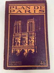
Sold2021PLAN DE PARIS Rues De Paris w/ MapLibrarie Hachette. "Liste Alphabetique Des Rues De Paris". Includes fold-out map by Imp Dufrenoy, Paris - "Grave chez Herisson Garin, 6, Rue Vercingetorix par E. Schwartz" in bottom left corner. Map mSee Sold Price
Sold2016Map of Paris, 1817Plan De Paris, 1817, overall framed size is 28 3/4" x 38 3/4", not removed from frameSee Sold Price
Sold2022AN ANTIQUE PRINTED MAP BY J. N. BELLIN, Paris 1752. PLAN DE LA VILLE DE MEACO. CopperplateAN ANTIQUE PRINTED MAP BY J. N. BELLIN, Paris 1752. PLAN DE LA VILLE DE MEACO. Copperplate Uncoloured. A well engraved and detailed plan of the port and city of Meaco, present-day Kyoto. Jacques NicolSee Sold Price
Sold2023[PARIS]. Plan garanti complet ou le guide dans Paris.Paris: Lallemand, 1855. Large folding map of Paris with small views of the major monuments overprinted near their location on the map. 16mo, (630 x 885mm). Large printed map with watercoloured foldingSee Sold Price
Sold2022(Early 20th c) MAPS OF EUROPE / MANY WARTIMEBataille de la Marne, French and British Front 1917, Ordnance Surveys Loughborough, Derby, Rickmansworth, Nouveau Plan de Paris Monumental N.B. circa 1890, printed by Defrenoy (Paris, France), overallSee Sold Price
Sold2020Georges Louis Rouge Plan of Paris Map 1765Georges-Louis Le Rouge (ca. 1712-1780), "Plan de Paris et de ses faubourgs en l'état qu'il étoit en 1765." This attractive map features the city of Paris along with points of interest. DimensionSee Sold Price
Sold2024Poster "Les jardins de Paris", illustrated map and plan of Paris with its parcs, gardens, monuments,The "Gardens of Paris" poster has the same proportions as a modern map but is illustrated, as were the antique maps, in the same way that the "portulans" of the sixteen century were.With precisely depSee Sold Price
Sold2020Hermes "Universite de Paris" Silk ScarfHermes silk scarf, titled above "Ici est le vrai portrait naturel de la ville, Cité, Université de Paris, 1576," depicting map of Paris based on Rossingol's plan of Paris, signed "Hermes Paris." 35"See Sold Price
Sold2023Map LotLot (3) framed maps including "PLAN DU CENTRE DE PARIS VOLD' OISEU" (overall in frame 28" x 38 1/2"), Spain (overall 25" x 34 1/2"), "GALLACIA REGNUM" (overall 21" x 23").See Sold Price
Sold20223 books, A Key to Uncle Tom's Cabin, Indian Wars, Paris3 books, "A Key to Uncle Tom's Cabin", presenting the original Facts & Documents, "Nouveau Plan Complete de Paris, avec ses Fortifications" dated 1849 (cover is loose, map in good condition) & "IndianSee Sold Price
Sold2022Pausanias ou Voyage Historique de la GrecePausanias ou Voyage Historique de la Grece Paris: F. G. Quillau, 1731. 2 volumes, 4to, engraved frontispiece, 3 folding maps and 4 folding plates, titles printed in red and black, contemporary calf, nSee Sold Price
Sold2023Plan de la Ville et Fauxbourgs de ParisPlan de la Ville et Fauxbourgs de Paris, 1763 historic wall map of Paris, 1777 "Divise en 20 quartiers dont la plus grande partie a ete rectifiee" by Debarme paper size 60" x 70 1/2", frame size 62" xSee Sold Price
Sold2023Delisle Map of Paris, France, Hand Colored 1716Important Map of Paris by Guillaume De L'Isle, Full Title: Plan de la Ville et Fauxbourgs de Paris. Dressee sur les observations astronomiques de l'Academie Royale des Sciences et sur les operations gSee Sold Price
Sold2022Nicolas de La Mare (French, 1639–1723), Antoine Coquart (French, 1668–1707), and Nicolas de FerNicolas de La Mare (French, 1639–1723), Antoine Coquart (French, 1668–1707), and Nicolas de Fer (French, 1646-1720), "Cinquieme Plan de la Ville de Paris," c. 1705, hand-colored map, preSee Sold Price
BonhamsLEVAILLANT (FRANÇOIS) Voyage dans l'intérieur de l'Afrique, par le cap de Bonne-Esp...£7,000
Jun 13Swann Auction Galleries(NORTH AMERICA.) Group of 4 seventeenth-to-eighteenth-century engraved maps.$500
3 days LeftFreeman's | Hindman[MAP]. SARTINE, Antoine Plan de la Barre et du Havre de Charles-Town...1778. RARE REVOLUTIONARY WAR$1,000(1 bid)
Jun 11Jasper521804 TRAVELS of Ledyard & Lucas in Africa antique w/ MAPS Voyages de MM. Lédyard$240
Jun 13Swann Auction Galleries(NEW YORK CITY.) Group of 9 nineteenth-century maps of Manhattan,$600(1 bid)
BonhamsCHATELAIN (HENRY ABRAHAM)] Atlas historique... vol. 6 (with Africa section only), 1719; and 3 ot...£500
BonhamsGRANDPRE (LOUIS DE) Voyage a la côte occidentale d'Afrique, fait dans les annees 1786 et 17...£500
BonhamsPREVOST D'EXILES (ANTOINE-FRANCOIS)] Voyages du Captaine Robert Lade en differentes parties de l...£600
BonhamsSONNERAT (PIERRE) Voyage aux Indes Orientales et a la Chine... suivi d'observations sur le Cap d...£300
Jun 13Swann Auction Galleries(WORLD.) Nicolas de Fer. Mappe-Monde ou Carte Generale de la Terre.$1,500


![[PARIS]. Plan garanti complet ou le guide dans Paris.: Paris: Lallemand, 1855. Large folding map of Paris with small views of the major monuments overprinted near their location on the map. 16mo, (630 x 885mm). Large printed map with watercoloured folding](https://p1.liveauctioneers.com/4096/288680/152743885_1_x.jpg?height=310&quality=70&version=1683550714)


![[Paris] - Stanford, Edward (1 of 1)](https://p1.liveauctioneers.com/94/330664/178342455_1_x.jpg?height=282&quality=70&version=1716466933)

![[MAP]. SARTINE, Antoine Plan de la Barre et du Havre de Charles-Town...1778. RARE REVOLUTIONARY WAR (1 of 1)](https://p1.liveauctioneers.com/197/329395/177650540_1_x.jpg?height=282&quality=70&version=1715364962)


![CHATELAIN (HENRY ABRAHAM)] Atlas historique... vol. 6 (with Africa section only), 1719; and 3 ot... (1 of 2)](https://p1.liveauctioneers.com/1043/316318/178467460_1_x.jpg?height=282&quality=70&version=1717430373)


![PREVOST D'EXILES (ANTOINE-FRANCOIS)] Voyages du Captaine Robert Lade en differentes parties de l... (1 of 1)](https://p1.liveauctioneers.com/1043/316318/178467525_1_x.jpg?height=282&quality=70&version=1717430397)


