Sold20211890 Map of ColoradoAuthor: Watson Title: 1890 Map of Colorado Medium: Ink on Paper Dimensions: 14.5"X11" Map of Colorado dated 1890. Printed and published by Watson in Chicago. Part of his World Atlas. Key lower left. ESee Sold Price
Sold20211890 Colorado MapTitle: 1890 Colorado Map Author: Watson Medium: Ink on Paper Dimensions: 13.5"X11" Description: Map of Colorado dated 1890. Published by Watson in Chicago. Part of his World Atlas. Key lower right. PrSee Sold Price
Sold2022Map of the Ouray Gold District; 1890 [152841]Real, original map of the Ouray Gold District, Ouray County, Colorado. Surveyed and Compiled by Wheeler & Hurlburt, F.L. Biddlecom and W.A Sherman, Civil and Mining Engineers. Ouray Colorado. JanuarySee Sold Price
Sold2023Grand Canyon Magic Lantern Glass Slides 1890-1920s (43)Arizona Grand Canyon National Park. Years: 1890-1920s. Highlights of the Canyons, Rivers, Valleys, Colorado River, Plateau, Temples, Trails, Granite Gorge, Maps, etc. Collection of 43 Magic Lantern GlSee Sold Price
Sold2021Letts & Son 1890 Map of RomePlan of Rome with over a hundred buildings, churches, gardens, arches, ruins, fortifications, plazas, and convents. Conservation framed. MEASUREMENTS: 12" high x 16" wide; overall with frame 19-3/4" hSee Sold Price
Sold20201890 Map of TexasAuthor: Gaskell Title: 1890 Map of Texas Medium: Ink on Paper Dimensions: 21.5"X13.5" Map of Texas dated 1890. This double folio map was part of Gaskell's Atlas of the World. Published by John F. WaitSee Sold Price
Sold2024CENTRAL AMERICA & CARIBBEAN. West Indies Mexico &c. Inset Panama Canal 1890 mapTITLE/CONTENT OF MAP: 'West Indies, Mexico, Central America, Colombia &c.; Inset map of The Panama Canal' DATE PRINTED: 1890 IMAGE SIZE: Approx 29.5 x 43.0cm, 11.75 x 17 inches (Large); Please note thSee Sold Price
Sold20211890 Map of Porto RicoAuthor: Cram Title: 1890 Map of Porto Rico Medium: Ink on Paper Dimensions: 22"X14.5" Map of Porto Rico dated 1890. Printed and published by George Cram in Chicago. Part of his Family Atlas. Double foSee Sold Price
Sold20211890 Map of HawaiiTitle: 1890 Map of Hawaii Medium: Ink on Paper Dimensions: 14.5"X11" Description: Map of Hawaii dated 1890. Printed and published by Watson in Chicago. Part of his World Atlas. Key upper right. ExplanSee Sold Price
Sold20211890 Map of PalestineAuthor: Watson Title: 1890 Map of Palestine Medium: Ink on Paper Dimensions: 15"X22 Map of Palestine dated 1890. Printed by Watson for People's Publishing Co. Part of his World Atlas. Published in ChiSee Sold Price
Sold20211890 Map of West TexasTitle: 1890 Map of West Texas Medium: Ink on Paper Dimensions: 14.5"X22.5" Description: Map of West Texas dated 1890. Engraved and published by George Cram in Chicago. Part of his Family Atlas. DoubleSee Sold Price
Sold20201890 Map of MontanaAuthor: Watson Title: 1890 Map of Montana Medium: Ink on Paper Dimensions: 22"X14.5" Map of Montana dated 1890. Published by Watson in Chicago. Key lower left. Double folio. Color coded for territoriaSee Sold Price
Sold20211890 Map of MexicoAuthor: Cram Title: 1890 Map of Mexico Medium: Ink on Paper Dimensions: 22"X14.5" Map of Mexico dated 1890. Printed and published by George Cram in Chicago. Double folio map. Inset of Lower CaliforniaSee Sold Price
Sold20211890 Map of BostonAuthor: Watson Title: 1890 Map of Boston Medium: Ink on Paper Dimensions: 11"X14.5" Map of Boston dated 1890. Printed and engraved by Watson in Chicago. Part of his World Atlas. With steam roads and hSee Sold Price
Sold20211890 Map of PalestineAuthor: Cram Title: 1890 Map of Palestine Medium: Ink on Paper Dimensions: 13.5"X21.5" Map of Palestine dated 1890. Printed and published by George Cram in Chicago. Part of his World Atlas. Double folSee Sold Price
Sold20211890 Map of DublinAuthor: Cram Title: 1890 Map of Dublin Medium: Ink on Paper Dimensions: 14"X11" Map of Dublin dated 1890. Engraved and published by George Cram in Chicago. Part of his Family Atlas. Key upper left. StSee Sold Price
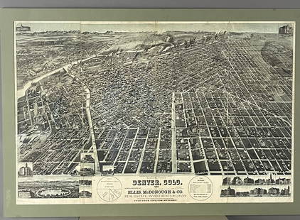
Sold20201890 Map of DenverAuthor: Watson Title: 1890 Map of Denver Medium: Ink on Paper Dimensions: 14.5"X11.5" Map of Denver dated 1890. Engraved and published by Watson in Chicago. Part of his World Atlas. Color coded for geSee Sold Price
Sold20211890 Map of ArizonaAuthor: Watson Title: 1890 Map of Arizona Materials: Ink on Paper Dimensions: 11"X14.5" Description: Map of Arizona dated 1890. Printed and published by Watson in Chicago. Part of his Family Atlas. KeSee Sold Price
Sold20211890 Map of JapanAuthor: Watson Title: 1890 Map of Japan Medium: Ink on Paper Dimensions: 11.5"X14.5" Map of Japan dated 1890. Printed by Watson for People's Publishing Co. Part of his World Atlas. Published in ChicagSee Sold Price
Sold20211890 Map of MontanaAuthor: Watson Title: 1890 Map of Montana Medium: Ink on Paper Dimensions: 21.5"X14.5" Map of Montana dated 1890. Printed and published by Watson in Chicago. Part of his World Atlas. Double folio map.See Sold Price
Sold20211890 Map of PhiladelphiaTitle: 1890 Map of Philadelphia Author: Watson Medium: Ink on Paper Dimensions: 14.5"X11" Description: Map of Philadelphia dated 1890. Printed and engraved by Watson in Chicago. Part of his World AtlaSee Sold Price
Sold20211890 Map of Ancient GreeceAuthor: Watson Title: 1890 Map of Ancient Greece Materials: Ink on Paper Dimensions: 14.5"X11.5" Description: Map of Ancient Greece and its colonies dated 1890. Printed and published by Watson in ChicSee Sold Price
Sold20201890 Map of OregonAuthor: Watson Title: 1890 Map of Oregon Medium: Ink on Paper Dimensions: 15"X11" Map of Oregon dated 1890. Engraved by Watson. Published by the People's Publishing Co. in Chicago. Key upper middle. CSee Sold Price
4 days LeftJasper521890 IN DARKEST AFRICA by HENRY M. STANLEY antique 2 VOLUMES illustrated w/ maps$75(1 bid)
Jun 23Schilb Antiquarian Rare Books1890 Livingstone 1ed In Darkest Africa Henry Stanley Emin Pasha Expedition MAP$18(4 bids)
Jun 23Schilb Antiquarian Rare Books1877 Geology Geography Surveys 1ed Nevada Wyoming Utah George Wheeler US West 2v$1
Jun 29JM Hobby Supply and Railroad Artifact AuctionsFlorence & Cripple Creek RR Public Timetable-September 1894$400
Jun 07Freeman's | HindmanWOOLWARD, Florence. The Genus Masdevallia... 1890-1896. FIRST EDITION.$1,200
4 days LeftJasper521886 Adams Chronological Chart of Civilizations -- A Chronological Chart of Ancient, Modern and$550
1818 AuctioneersArchaeology. Egyptology. Naville, Edouard - The Temple of Deir El Bahari. London: Egypt£10(1 bid)
1818 AuctioneersMilitary. Groves, Major J. Percy - Some Notable Generals and Their Notable Battles. London: Griffith£5(1 bid)
1818 AuctioneersLiterature. Jerome, Jerome K. - Three Men in a Boat. 1889, later state with '11 Quay Street' on£14(1 bid)
4 days LeftCedarburg Auction & Appraisals LLCSet of Four Maps Showing All of Spain and Portugal$375(2 bids)


![Map of the Ouray Gold District; 1890 [152841]: Real, original map of the Ouray Gold District, Ouray County, Colorado. Surveyed and Compiled by Wheeler & Hurlburt, F.L. Biddlecom and W.A Sherman, Civil and Mining Engineers. Ouray Colorado. January](https://p1.liveauctioneers.com/2699/258191/134290994_1_x.jpg?height=310&quality=70&version=1660351799)


