Sold20201884 Mitchell Map of Original 13 US Colonies -- 1776 -Title: 1884 Mitchell Map of Original 13 US Colonies -- 1776 - Map of the Thirteen Original Colonies Cartographer: S Mitchell Year/Place: 1884, Philadelphia Dimensions: 11.5 X 13.5 in. Descriptions: ThSee Sold Price
Sold2018Map of Mexico, Central America, and the West Indies.Title/Content of Map: Map of Mexico, Central America, and the West Indies. Date Printed: 1884 ca. Cartographer: MITCHELL, SAMUEL AUGUSTUS (JR.) Size: 13.3X21.3 Map showing lower U.S., Mexico, West IndSee Sold Price
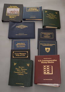
Sold2020Large Lot Of Stamps, Coins, Bills LotIncludes the Civil War stamps collection fixturing artwork by mort Kunstler, The complete collection of US presidential commemorative stamps, fill attic history of original 13 colonies, the US famousSee Sold Price
Sold20211889 Map of the US Original ColoniesAuthor: Cram Title: 1889 Map of the US Original Colonies Medium: Ink on Paper Dimensions: 11"X14.5" Map of the original colonied engraved and published by George Cram in Chicago. Dated 1889. Map has eSee Sold Price
Sold2016Palestine under the Judges and Kings by MitchellOriginal Engraved map my Augustus Mitchell, 1884. Nice original color. Shows the Distribution of the Twelve Tribes, the Environs of Jerusalem and the Routes of teh Israelites from Egypt through the DeSee Sold Price
Sold20211884 Mitchell Map of Boston -- Plan of BostonTitle: 1884 Mitchell Map of Boston -- Plan of Boston Cartographer: S Mitchell Year / Place: 1884, Philadelphia Map Dimension (in.): 13.5 X 21.3 in. This is a very nice, large map of Boston, with greatSee Sold Price
Sold20231776 Bicentennial 13 Pewter Spoon SetRepresenting the 13 original colonies with 13 distinguished founders from 1776. Includes wood display rack. Produced by The Franklin Mint. 18.5"h x 13"w. 3 lbs. 3 oz.See Sold Price
Sold2016Mitchell: County Map of Florida 1867Map: County Map of Florida Maker: Mitchell Size: 11 x 13.25 inches Counties in original wash color. Inset of Mobile, AL. No Reserve: This lot starts at $1 and has no reserve as a courtesy so that collSee Sold Price
Sold2020Mitchell Map of Western U.S.*** START PRICE IS THE RESERVE *** [America] MITCHELL, Samuel Augustus (1792-1868). A New Map of Texas, Oregon and California with the Regions Adjoining. Engraving with original hand color, with origiSee Sold Price
Sold2017Mitchell: Map of the United States & Territories, 1860Map: United States & Territories Maker: Mitchell Date: 1860 Size: 13.25 x 21.25 inches Condition: Some light soil marks in margin. Nice original hand coloring. Three very tiny spots in map. Very niceSee Sold Price
Sold2017Mitchell: Map of North America, 1848North America, S. Augustus Mitchell, 1848. 13 x 15.75 inches. Great transitional map showing political boundaries within that short time period after the Canadian/U.S. boundary settlement and before tSee Sold Price
Sold2020County Map of Kentucky and TennesseeTitle: County Map of Kentucky and Tennessee Publication Date: 1884 Cartographer: MITCHELL, S.A. Publisher: MITCHELL, S.A. Size: 13 X 20.8 Additional Information: Detailed map showing many townships, cSee Sold Price
Sold2018Young New Map of TexasA New Map of Texas with the contiguous American and Mexican States. James Hamilton Young. Engraved map with original hand color. Philadelphia: S. Augustus Mitchell, 1839. 13 x 15 1/2 inches visible, 1See Sold Price
Sold2017Mitchell: Plan of BostonMap: Plan of Boston (original Antique map) Maker/Publisher: S. Augustus Mitchell Publishing Date: 1872 Size: 13.5 x 20.75 inches Hard-to-find 1872 Mitchll map of Boston in the more unusual 2-page formSee Sold Price
Sold20171860 Minnesota and Dacotah, S. Augustus Mitchell, Jr1860 Minnesota and Dacotah, S. Augustus Mitchell, Jr. 10.625 x 13.125 inches. Engraved map with exceptionally bright original hand-coloring. This attractive, historical map depicts the new State ofSee Sold Price
Sold20211852 Cowperthwait, Desilver, Butler map of TexasThe horizontal layout not commonly seen. “No. 13 Map of the State of Texas Engraved to Illustrate Mitchell’s School and Family Geography.” Nicely detailed with original hand-coloringSee Sold Price
Sold2016Map of Washington, DC, 1853Original engraving from Illustated Gazetter of the US, published by Phelps, Fanning and Company, 1853. Dimensions: 10” x 13 1/2” No Reserve This item ships from Ocean View, DE.See Sold Price
Sold2017Mitchell/Cowperthwait: Antique Map of the West US, 1850Title: Map of California, Oregon, Utah, and New Mexico by Mitchell and Cowperthwait Date: 1850 Medium: Lithograph Dimensions (in): 13.5 x 17 Condition: Good Condition with a little of foxing Samuel AuSee Sold Price
Sold2019Beautiful 1860 map of EuropeMap of Europe Showing its Political Divisions. Clean with good original hand color. 1860 date; from Mitchell’s 1862 atlas. Hint of toning at three edges. 10.75 x 13.375. Reserve: $40.00 Shipping: DoSee Sold Price
Sold2021Bertoia Sound Sculpture B2407A Val Bertoia sound sculpture, B2407, paying homage to the Betsy Ross flag. (13) beryllium rods are position in a circle, representing the original (13) colonies. (37) rods, representing the remainingSee Sold Price
Sold20241778 "Il Canada" original map depicting Canada and the US. Hand colored. Fold down center. Framed.1778 "Il Canada" original map depicting Canada and the US. Hand colored. Fold down center. Framed. 21 x 25in.See Sold Price
Sold20151845 MITCHELL'S REFERENCE & DISTANCE WALL MAP U.S.SHOWING MITCHELL'S 1845 REFERENCE AND DISTANCE WALL MAP OF THE UNITED STATES WITH GENERAL MAP OF THE US WITH CONTIGUOUS BRITISH AND MEXICAN POSSESSIONS.PHILADELPHIA : S. AUGUSTUS MITCHELL COPPER-ENGRASee Sold Price
Sold2015Campaign And Battle of Gettysburg From Official RecordsFiebeger [Colonel] G.J. Campaign and Battle of Gettsyburg from The Official Records... West Point, NY: US Military Academy, 1907.Note: Folding maps, original cloth.Inv. 978See Sold Price
3 days LeftNY Elizabeth FIRST US EDITION OF 1869 MALAY ARCHIPELAGO BY A.WALLACE, ANTIQUE ILLUSTRATED WITH MAPS$50(1 bid)
3 days LeftRapid Estate Liquidators and Auction GalleryOriginal Framed Marcia Herring Acrylic On Paper Of Colorful Flowers$300
Jun 07Freeman's | Hindman[MAP]. SARTINE, Antoine Plan de la Barre et du Havre de Charles-Town...1778. RARE REVOLUTIONARY WAR$1,000(1 bid)
6 days LeftMynt AuctionsWESLEY WALKER NEW YORK- JSA/COA SIGNED OFFICIAL LICENSED MITCHELL & NESS JERSEY$10(1 bid)
5 days LeftMynt AuctionsWESLEY WALKER NEW YORK JSA/COA SIGNED OFFICIAL LICENSED MITCHELL & NESS JERSEY$10
675 Lots AwayMynt AuctionsBARRY SANDERS DETROIT LION W/COA SIGNED OFFICIAL LICENSED MITCHELL & NESS JERSEY$10(1 bid)
5 days LeftMynt AuctionsLANCE ALWORTH CHARGERS W/COA SIGNED OFFICIAL LISENSED MITCHELL & NESS JERSEY$10
1134 Lots AwayMynt AuctionsLot of (13) San Diego Padres Autographed 1978 TOPPS Baseball Cards 183165$10
Jun 06Freeman's | HindmanTHOREAU, Henry David (1817-1862). [The Season Books]. Early Spring in Massachusetts. 1881. --$400
Jun 07Freeman's | HindmanROOSEVELT, Theodore. African Game Trails. 1910. FIRST TRADE EDITION. PRESENTATION COPY INSCRIBED BY$400
Jun 07Freeman's | Hindman[LEWIS & CLARK EXPEDITION]. The Journal of the Lewis & Clark Expedition. Gary E. Moulton, editor.$300
2 days LeftLion and UnicornDepartment 56 Historical Landmark Series, Cathedral of Saint Paul$25(3 bids)


![Mitchell Map of Western U.S.: *** START PRICE IS THE RESERVE *** [America] MITCHELL, Samuel Augustus (1792-1868). A New Map of Texas, Oregon and California with the Regions Adjoining. Engraving with original hand color, with origi](https://p1.liveauctioneers.com/1968/163248/82424595_1_x.jpg?height=310&quality=70&version=1583340284)


![Campaign And Battle of Gettysburg From Official Records: Fiebeger [Colonel] G.J. Campaign and Battle of Gettsyburg from The Official Records... West Point, NY: US Military Academy, 1907.Note: Folding maps, original cloth.Inv. 978](https://p1.liveauctioneers.com/2945/73513/37995294_1_x.jpg?height=310&quality=70&version=1434131929)


![[MAP]. SARTINE, Antoine Plan de la Barre et du Havre de Charles-Town...1778. RARE REVOLUTIONARY WAR (1 of 1)](https://p1.liveauctioneers.com/197/329395/177650540_1_x.jpg?height=282&quality=70&version=1715364962)


![THOREAU, Henry David (1817-1862). [The Season Books]. Early Spring in Massachusetts. 1881. -- (1 of 1)](https://p1.liveauctioneers.com/197/329405/177652637_1_x.jpg?height=282&quality=70&version=1715364568)


![[LEWIS & CLARK EXPEDITION]. The Journal of the Lewis & Clark Expedition. Gary E. Moulton, editor. (1 of 1)](https://p1.liveauctioneers.com/197/329395/177650557_1_x.jpg?height=282&quality=70&version=1715364962)


