Sold20201883 Map of FloridaAuthor: Cram Title: 1883 Map of Florida Medium: Ink on Paper Dimensions: 11"X13.5" Description: Map of Florida dated 1883. Engraved and published by George Cram in Chicago. Key lower left. Inset of thSee Sold Price
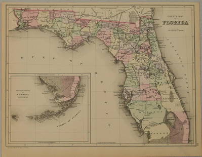
Sold20211883 Mitchell/Bradley Map of Florida -- County Map ofTitle: 1883 Mitchell/Bradley Map of Florida -- County Map of Florida Cartographer: Mitchell / Bradley Year / Place: 1883, Philadelphia Map Dimension (in.): 10.5 X 14.4 in. This is a rather handsome coSee Sold Price
Sold20241883 FLORIDA for Tourists & Settlers Illustrated Fort Barrancas MAP Fine BINDING1883 FLORIDA for Tourists & Settlers Illustrated Fort Barrancas MAP Fine BINDING “Florida for Tourists” is a fine, 19th-century tour guidebook for travelers and settlers into Florida. WrittenSee Sold Price
Sold20202 Hand Colored Maps - Florida & AlabamaTwo Gray's Atlas Maps on one sheet - Florida & Alabama Depicts railroad lines, common roads, canals, topography, etc. Maps are on each side of one sheet. A beautiful & rarSee Sold Price
Sold2017Bellin: Antique Map, Florida Coastal Chart, 1764Map: Carte de la Coste de la Floride Cartographer: Bellin Place & Date: Paris / 1764 Size: 13 1/4" x 8 3/4" Condition: outline color; very light age toning at outer edges of margins A beautifully presSee Sold Price
Sold2024CAUCASUS. Russia Circassia Astrakhan Georgia Azerbaijan Armenia. LETTS 1883 mapTITLE/CONTENT OF MAP: 'Russia No.9' DATE PRINTED: 1883 IMAGE SIZE: Approx 36.5 x 43.0cm, 14.5 x 16.75 inches (Large); Please note that this is a folding map. TYPE: Antique colour atlas map CONDITION:See Sold Price
Sold2024Rare Hand-coloured Map - Florida - Louisiana - United States - BellinIts finely engraved, hand-coloring engraved map from the Dutch edition of acques Nicolas Bellin "Histoire General of Travel". Published in Amsterdam, 1770 year. Carte de la Floride de la LouSee Sold Price
Sold2020Scarce 1883 map of TexasExtremely scarce early 1883 map is different from the more common later 1883 and 1884 version of Cram’s Texas. The later versions have green county borders with rose hachures for the state outline.See Sold Price
Sold20201883 Map of New York CityAuthor: Cram Title: 1883 Map of New York City Medium: Ink on Paper Dimensions: 21.5"X13.5" Map of New York City dated 1883. Engraved and published by George Cram in Chicago. Double folio map. Key loweSee Sold Price
Sold2023EARLY COLONIAL AFRICA pre Scramble for Africa. Mountains of Kong. LETTS 1883 mapTITLE/CONTENT OF MAP: 'Letts's General map of Africa; Inset map of British Isles' Shows the non-existent Mountains of Kong DATE PRINTED: 1883 IMAGE SIZE: Approx 36.0 x 42.5cm, 14 x 16.75 inches (LargeSee Sold Price
Sold20211883 Map of MontanaAuthor: Cram Title: 1883 Map of Montana Medium: Ink on Paper Dimensions: 21.5"X14" Map of Montana dated 1883. Printed and published by George Cram in Chicago. Part of his Family Atlas. Double folio maSee Sold Price
Sold20211883 Map of the US Southern StatesAuthor: Cram Title: 1883 Map of the US Southern States Medium: Ink on Paper Dimensions: 22"X13.5" Map of the Southern states dated 1883. Engraved and published by George Cram in Chicago. It captures ASee Sold Price
Sold20211883 Map of ColoradoAuthor: Cram Title: 1883 Map of Colorado Medium: Ink on Paper Dimensions: 13.5"X11" Map of the Colorado dated 1883. Printed and published by George Cram in Chicago. Part of his World Atlas. Key lowerSee Sold Price
Sold20211883 Map of the United StatesAuthor: Cram Title: 1883 Map of the United States Medium: Ink on Paper Dimensions: 21"X14" Map of the US dated 1883. Engraved and published by George Cram in Chicago. Double folio map. Color coded forSee Sold Price
Sold20201883 Map of the Indian TerritoryAuthor: Cram Title: 1883 Map of the Indian Territory Medium: Ink on Paper Dimensions: 13.5"X11" Map of the Indian Territory dated 1883. Engraved and published by George Cram in Chicago. Key lower leftSee Sold Price
Sold20211883 Map of CaliforniaAuthor: Cram Title: 1883 Map of California Medium: Ink on Paper Dimensions: 13.5"X22" Map of California dated 1883. Printed and published by George Cram in Chicago. Part of his World Atlas. Double folSee Sold Price
Sold20211883 Map of the Washington TerritoryAuthor: Cram Title: 1883 Map of the Washington Territory Medium: Ink on Paper Dimensions: 13.5"X11" Map of Washington territory dated 1883. Engraved and published by George Cram in Chicago. Color codeSee Sold Price
Sold20211883 Map of ChinaAuthor: Cram Title: 1883 Map of China Medium: Ink on Paper Dimensions: 13.5"X22" Map of China dated 1883. Engraved and published by George Cram in Chicago. Part of his Family Atlas. Double folio map.See Sold Price
Sold2024BALKANS. Wallachia Moldavia Eastern Roumelia N Greece. Railways. LETTS 1883 mapTITLE/CONTENT OF MAP: 'South East Europe - Turkey, Roumania, Servia &c.' DATE PRINTED: 1883 IMAGE SIZE: Approx 36.0 x 42.0cm, 14 x 16.5 inches (Large); Please note that this is a folding map. TYPE: AnSee Sold Price
Sold20201883 Map of ArizonaAuthor: Cram Title: 1883 Map of Arizona Medium: Ink on Paper Dimensions: 11"X13.5" Map of Arizona dated 1883. Engraved and published by George Cram in Chicago. Key located lower left. Population and tSee Sold Price
Sold20201883 Map of MinnesotaAuthor: Cram Title: 1883 Map of Minnesota Medium: Ink on Paper Dimensions: 11"X13.5" Map of Minnesota dated 1883. Engraved and published by George Cram in Chicago. Key upper right. Explanation on popuSee Sold Price
Sold20211883 Map of North CarolinaTitle: 1883 Map of North Carolina Medium: Ink on Paper Dimensions: 14"X11" Description: Map of North Carolina dated 1883. Part of Watson Universal Atlas published Chicago. Lower right inset of the WesSee Sold Price
Sold20211883 Map of WyomingAuthor: Cram Title: 1883 Map of Wyoming Medium: Ink on Paper Dimensions: 13.5"X11" Map of Wyoming dated 1883. Printed and published by George Cram in Chicago. Part of his Word Atlas. Key upper right.See Sold Price
Sold2024DOC Map, Florida Bay, United StatesA map of the Florida Bay and Key Largo with their surrounding areas on one side. On the reverse side is a map of Miami and Biscayne Bay along with information of that time. Publishing stamp by "U.S DeSee Sold Price
7 days LeftJasper52CENTRAL ASIA. Bokhara Russian Turkestan Tomsk Great Horde Turgan. LETTS 1883 map$8
Jun 06Freeman's | HindmanSTEVENSON, Robert Louis (1850-1894). Treasure Island. London, Paris & New York: Cassell & Company,$1,500
May 25RbfineartsHistorical Map of the State of Kentucky by Karl Smith 1933 Daniel Boone & Companions View$20(1 bid)
6 days LeftThomaston Place Auction GalleriesCOLLECTION OF TRAVEL EPHEMERA, BROCHURES, BOOKLETS, MAPS 1900-1950$100
May 25RbfineartsHistorical Map of the Chesapeake Bay By Edwin Tunis Published By The National Brewing Co.$20(1 bid)
May 30Forum AuctionsStevenson (Robert Louis) Treasure Island, first edition, first issue, 1883.£1,000
6 days LeftJasper52Map of the Campaign in East Tennessee, Mississippi, Georgia, Alabama, and Florida.$65
8 hrs LeftFreeman's | HindmanCamille Bombois (French, 1883-1970) Two Figures in a Lavender Field$1,000
2 days LeftTrillium Antique Prints & Rare BooksDe Bry - Florida: King Outina Consulting a Sorcerer$75
6 days LeftJasper52Progress Sketch Sec. Vii West Coast of Florida St. Joseph's Bay to Mobile Bay ... June 30, 1882$80
2 days LeftTrillium Antique Prints & Rare BooksCatesby, Folio - Brown Moth with Maho (Cork Tree). 2-90$200(1 bid)
2 days LeftTrillium Antique Prints & Rare BooksCatesby, Folio - Mangrove Grape Tree with Goldenrod Moth. 2-96$200
2 days LeftTrillium Antique Prints & Rare BooksCatesby, Folio - Rattlesnake (Canebrake Rattlesnake). 2-41$200