Sold20231881 Map of Utah & Nevada by Mitchell1881 Map of Utah & Nevada by Mitchell. Overall size 22 1/2"h x 29 1/2"wSee Sold Price
Sold2022Nevada & Utah 1880Title/Content of Map: Nevada & Utah 1880 Date Printed: 1880 Material/Medium: paper Size: folio, 23x 15 inches Additional Info: Hand colored county & township map of Utah & Nevada by Mitchell. Map measSee Sold Price
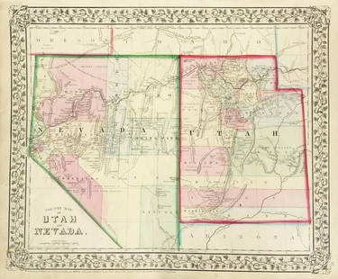
Sold2019Mitchell: County Map of Utah & NevadaMap Title: County Map of Utah and NevadaCartographer: S. A. Mitchell Place/Date: Philadelphia / 1870 Size: 14" x 11 5/8" Condition: full color; light overall age toning The beautifully detailed and coSee Sold Price
Sold20231877 Mitchell Map of Utah and Nevada [verso] Arizona and New Mexico -- County Map of of Utah andTitle: 1877 Mitchell Map of Utah and Nevada [verso] Arizona and New Mexico -- County Map of of Utah and Nevada [verso] County Map Arizona and New Mexico Cartographer: S Mitchell Year / Place: 1877 PhiSee Sold Price
Sold20191876 Mitchell Map of Utah and Nevada [verso] ArizonaTitle/Content of Map: 1876 Mitchell Map of Utah and Nevada [verso] Arizona and New Mexico -- County Map of of Utah and Nevada [verso] County Map Arizona and New Mexico Date: 1876 Philadelphia CartograSee Sold Price
Sold2017Mitchell: Antique County Map of Utah & Nevada, 1870[Utah, Nevada]. N. p: S. Augustus Mitchell, 1870s. The map was drawn and engraved by W. H. Gamble of Philadelphia. Coloured map. Approximately 11-3/4 x 14-/4 inches image area, one sheet, matted. FineSee Sold Price
Sold20207 Maps incl North America and PanamaIncludes Panama to Guayaquil (Thomas Kitchin), Mexico & Gautemala (Thomas Coperthwait & Co., 1850), Utah & Nevada (Mitchell), California (Mitchell, 1874), State of Texas (Mitchell, 1852), North AmericSee Sold Price
Sold2018Mitchell: Antique Map of Utah and Nevada,1870Title/Content of Map: 1870 Mitchell Map of Utah and Nevada -- County Map of Utah and Nevada Date Printed: 1870 Philadelphia Cartographer: S Mitchell Size: 10.6 X 13.5 in. Handsome county map of Utah aSee Sold Price
Sold20201869 Mitchell Map of Western US [verso] Mexico andTitle: 1869 Mitchell Map of Western US [verso] Mexico and Central America -- XIX California, Oregon, Idaho, Utah, Nevada, Arizona and Washington [verso] XX Mexico and Central America Cartographer: S MSee Sold Price
Sold20201892 Cowles Civil War Map of Utah, Nevada and Most ofTitle: 1892 Cowles Civil War Map of Utah, Nevada and Most of California plus March Route of the Army of Tennessee -- Territory and Military Department of Utah…1860 [and] March Routes of Army of TennSee Sold Price
Sold2020USA 1903 Lot of 6 State Maps. California, Utah, NevadaPlus Washington, Colorada and Arizona/New Mexico. Lithograph Maps Published 1903 by Adam & Charles Black, Edinburgh & London for "Encyclopaedia Brittannica" Tenth Edition. Centre fold as published. PaSee Sold Price
Sold2023Scarce Johnson map of the Great Western states, 1864Authentic vintage map of California, Utah, Nevada, Colorado, New Mexico, and Arizona. Created during a great time of expansion and change in the western United States while the Civil War was still ragSee Sold Price
Sold2019California Southwest Antique MapEarly map: California, also Utah, Nevada, Colorado, New Mexico and Arizona. Map by A.J. Johnson, New York, c. 1870. 18" x 26 1/2".See Sold Price
Sold2015Plan of Milwaukee & Lake Michigan by Mitchell, 1881Original steel engraving by Augustus Mitchell, 1881. Map features city streets & railroads. Dimensions: 15” x 12”See Sold Price
Sold2015Town of Dover in Dutchess County, Atlas of New York byOriginal steel engraving by Augustus Mitchell, 1881. Map features city streets & railroads. Dimensions: 15” x 12”See Sold Price
Sold2020Map of California, Oregon Utah Nevada +Map of California, Oregon, Idaho, Utah, Nevada, Arizona and Washington PLUS Mexico and Central America on verso Two maps on one sheet. (back to back). Hand colored.See Sold Price
Sold20231855 Beckwith Map of Northern Utah and Nevada -- Map No. 2 From Great Salt Lake to the HumboldtTitle: 1855 Beckwith Map of Northern Utah and Nevada -- Map No. 2 From Great Salt Lake to the Humboldt Mountains from Explorations and Surveys Made Under the Direction of Hon. Jefferson Davis, Sec. ofSee Sold Price
Sold20221855 Beckwith Map of Northern Utah and Nevada -- MapTitle: 1855 Beckwith Map of Northern Utah and Nevada -- Map No. 2 From Great Salt Lake to the Humboldt Mountains from Explorations and Surveys Made Under the Direction of Hon. Jefferson Davis, Sec. ofSee Sold Price
Sold2021Johnson's California Map w/ Territories - Utah,Johnson's California Map w/ Territories - Utah, Colorado, Nevada, etc....21" x 27 1/2"See Sold Price
Sold2017VINTAGE MAPS AND MOREVINTAGE MAPS - UTAH OIL REFINING COMPANY - WESTERN STATES - SHELL - MAP OF NEVADA/UTAH AND ARIZONA/NEW MEXICO - RPM MOTOR OIL MAP - CALIFORNIA POINTS OF INTEREST AND TOURING MAP - AND MANY MORE - ALLSee Sold Price
Sold2017Colton: Map of California Nevada Utah Colorado ArizonaColton's Map of California, Nevada, Utah, Colorado, Arizona & New Mexico, 1865/1869. Early edition of Colton's map of the Southwestern United States. Unlike in the prior edition, Nevada is no longer tSee Sold Price
Sold2021Bancroft's California, Nevada, etc. 1864Heading: Author: Bancroft, Hubert Howe Title: Bancroft's Map of California, Nevada, Utah and Arizona Place Published: San Francisco Publisher:H.H. Bancroft & Company Date Published: 1864See Sold Price
Sold2021Bancroft's Map of California, Nevada, 1873Heading: Author: Bancroft, Albert Little Title: Bancroft's Map of California, Nevada, Utah and Arizona, Published by A. L. Bancroft & Compy. Booksellers & Stationers San Francisco Cal. 1873 Place PubSee Sold Price
Sold2022Scarce Johnson map of the Great Western states, 1864Antique map of California, Nevada, Utah, Colorado, New Mexico, and Arizona. Published during a great time of expansion and change in the U.S. West, as well as during the Civil War. Here Utah displaysSee Sold Price
5 days LeftJasper52Johnson's California with Utah, Nevada, Colorado, New Mexico & Arizona 1866 map$440
Jun 23Schilb Antiquarian Rare Books1877 Geology Geography Surveys 1ed Nevada Wyoming Utah George Wheeler US West 2v$1(1 bid)
15 hrs LeftSimpson Galleries, LLC.J.H. Young (1792-1870) AN AMERICAN FEDERAL PERIOD MAP, "Mitchell's Travellers Guide Through the$500
4 days LeftJasper521887 Mitchell Map of New Mexico and Arizona -- County and Township Map of Arizona and New Mexico$80
4 days LeftJasper521878 Mitchell Map of Georgia and Alabama -- County Map of the States of Georgia and Alabama$50
4 days LeftJasper521872 Mitchell Map of Massachussetts, Connecticut and Rhode Island -- County Map of Massachussetts,$40
4 days LeftJasper521872 Mitchell Map of Louisiana, Arkansas and Mississippi -- County Map of the States of Arkansas,$40
5 days LeftJasper52Hawaiian or Sandwich Islands North Pacific Ocean ADMIRALTY chart 1881 (1955) map$360
BonhamsLINFORTH (JAMES, EDITOR) Route from Liverpool, to Great Salt Lake Valley Illustrated...by Freder...£1,400
6 days LeftSwann Auction Galleries(NORTH AMERICA.) Samuel Augustus Mitchell. New National Map, Exhibiting the United States with the$450
2 days LeftHolabird Western Americana CollectionsRare Map of Virginia City, Nevada Mining Claims [164472]$170
Featured5 days LeftJasper52United States of North America, Pacific States by Joseph Wilson Lowry 1860 map$340
7 days LeftDuMouchellesWilliam H. Gamble (American, B. 1863) Hand Colored Engraving, Ca. 1863, "County Map of Michigan And$50(1 bid)


![1877 Mitchell Map of Utah and Nevada [verso] Arizona and New Mexico -- County Map of of Utah and: Title: 1877 Mitchell Map of Utah and Nevada [verso] Arizona and New Mexico -- County Map of of Utah and Nevada [verso] County Map Arizona and New Mexico Cartographer: S Mitchell Year / Place: 1877 Phi](https://p1.liveauctioneers.com/5584/293457/155766077_1_x.jpg?height=310&quality=70&version=1687903812)
![1876 Mitchell Map of Utah and Nevada [verso] Arizona: Title/Content of Map: 1876 Mitchell Map of Utah and Nevada [verso] Arizona and New Mexico -- County Map of of Utah and Nevada [verso] County Map Arizona and New Mexico Date: 1876 Philadelphia Cartogra](https://p1.liveauctioneers.com/5584/137769/69881187_1_x.jpg?height=310&quality=70&version=1552435690)
![Mitchell: Antique County Map of Utah & Nevada, 1870: [Utah, Nevada]. N. p: S. Augustus Mitchell, 1870s. The map was drawn and engraved by W. H. Gamble of Philadelphia. Coloured map. Approximately 11-3/4 x 14-/4 inches image area, one sheet, matted. Fine](https://p1.liveauctioneers.com/5584/107399/55057774_1_x.jpg?height=310&quality=70&version=1501794677)


![1869 Mitchell Map of Western US [verso] Mexico and: Title: 1869 Mitchell Map of Western US [verso] Mexico and Central America -- XIX California, Oregon, Idaho, Utah, Nevada, Arizona and Washington [verso] XX Mexico and Central America Cartographer: S M](https://p1.liveauctioneers.com/5584/188299/94765046_1_x.jpg?height=310&quality=70&version=1608072723)
![1892 Cowles Civil War Map of Utah, Nevada and Most of: Title: 1892 Cowles Civil War Map of Utah, Nevada and Most of California plus March Route of the Army of Tennessee -- Territory and Military Department of Utah…1860 [and] March Routes of Army of Tenn](https://p1.liveauctioneers.com/5584/162681/82155385_1_x.jpg?height=310&quality=70&version=1583273475)


![Ely Mining Stocks, 4 [181252] (1 of 1)](https://p1.liveauctioneers.com/2699/331499/178846168_1_x.jpg?height=282&quality=70&version=1717095214)

![Nevada Ore Deposit Map, 1866 [173205] (1 of 1)](https://p1.liveauctioneers.com/2699/331499/178846263_1_x.jpg?height=282&quality=70&version=1717095214)


![Rare Map of Virginia City, Nevada Mining Claims [164472] (1 of 1)](https://p1.liveauctioneers.com/2699/331499/178846248_1_x.jpg?height=282&quality=70&version=1717095214)


![Rawhide Mining Stocks, 4 [182126] (1 of 1)](https://p1.liveauctioneers.com/2699/331499/178846190_1_x.jpg?height=282&quality=70&version=1717095214)


![[Prints] Moran, Thomas: Valley of Babbling Waters, Southern Utah (1 of 2)](https://p1.liveauctioneers.com/65/332523/179335250_1_x.jpg?height=282&quality=70&version=1717709446)