Sold20231880 US Census Map of Wheat Production per Capita -- Map of the United States Showing theTitle: 1880 US Census Map of Wheat Production per Capita -- Map of the United States Showing the Distribution of Production of Wheat in Bushels per Capita… Cartographer: US Census Bureau Year /See Sold Price
Sold20231880 US Census Map of Corn Production per Capita -- Map of the United States Showing theTitle: 1880 US Census Map of Corn Production per Capita -- Map of the United States Showing the Distribution of Production of Indian Corn in Bushels per Capita… Cartographer: US Census Bureau YeSee Sold Price
Sold20231880 US Census Map of Oats Production per Capita -- Map of the United States Showing theTitle: 1880 US Census Map of Oats Production per Capita -- Map of the United States Showing the Distribution of Production of Oats in Bushels per Capita… Cartographer: US Census Bureau Year / PlSee Sold Price
Sold20211880 Gannett Climate Map of the US with IsothermalTitle: 1880 Gannett Climate Map of the US with Isothermal Minimum Temperature Lines -- Map of the United states Showing the Distribution of Lines of Minimum Temperature… Cartographer: H Gannett / DeSee Sold Price
Sold20221880 US Census Map of Oats Production -- Map of the United States Showing the Average Yield of OatsTitle: 1880 US Census Map of Oats Production -- Map of the United States Showing the Average Yield of Oats per Acre… Cartographer: US Census Bureau Year / Place: 1880, Boston Map Dimension (in.)See Sold Price
Sold20231880 US Census Map of Barley Production -- Map of the United States Showing the Average Yield ofTitle: 1880 US Census Map of Barley Production -- Map of the United States Showing the Average Yield of Barley per Acre… Cartographer: US Census Bureau Year / Place: 1880, Boston Map Dimension (See Sold Price
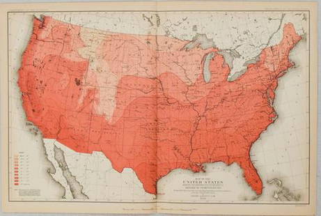
Sold20221879 Powell US Rain Chart Map -- Rain Chart of the United States Showing by Isothermal Lines theTitle: 1879 Powell US Rain Chart Map -- Rain Chart of the United States Showing by Isothermal Lines the Distribution of the Mean Annual Precipitation in Rain and Melted Snow Cartographer: J W Powell /See Sold Price
Sold20181880 Gray US Map -- Gray's New Map of the United StatesReserve Reduced! Title/Content of Map: 1880 Gray US Map -- Gray's New Map of the United States Date: 1880, Philadelphia Cartographer: F Gray Size: 15.5 x 26.7 in. A very nice large US map, showing greSee Sold Price
Sold20181880 Gray US Map -- Gray's New Map of the United StatesTitle/Content of Map: 1880 Gray US Map -- Gray's New Map of the United States Date: 1880, Philadelphia Cartographer: F Gray Size: 15.5 x 26.7 in. A very nice larger US map, showing great deal of topogSee Sold Price
Sold20191880 Gray US Map -- Gray's New Map of the United StatesTitle/Content of Map: 1880 Gray US Map -- Gray's New Map of the United States Date: 1880, Philadelphia Cartographer: F Gray Size: 15.5 x 26.7 in. A very nice large US map, showing great deal of topogrSee Sold Price
Sold2023Rare 19thc Census Map, U.S. Agricultural ProductionExtremely rare, original 1876 atlas map of the United States Agriculture Production - five agricultural maps (in inset form) of the production of wheat, hay, corn, cotton and tobacco. Each map distingSee Sold Price
Sold2020Reconnoissance Map of the United States Showing theTitle: Reconnoissance Map of the United States Showing the Distribution of The Geologic System Cartographer: MC GEE, W. J. Date: 1893 Publisher: U.S. GEOLOGICAL SURVEY Size: 17.5Height - 28.25Width AdSee Sold Price
Sold2018Rand McNally: Antique US Population Trend Map, 1892Title/Content of Map: 1892 Rand McNally US Population Trend Map -- Rand McNally & Co.'s Map of the United States Showing the Increase and Decrease of Population 1880 to 1890 Date Printed: 1892, ChicagSee Sold Price
Sold2017Mitchell: Railroad & Steamboat Map of the US, 1887Map: 1887 Mitchell Railroad and Steamboat Map of the US -- Railroad Map of the United States, Showing the through Lines of Communication from the Atlantic to the Pacific. Together with the Various SteSee Sold Price
Sold20171862 Johnson Civil War Military Map of US1862 Johnson Civil War Military Map of US -- Johnson's New Military Map of the United States Showing the Forts, Military Posts &c. all the Military Divisions with Enlarged Plans of Southern Harbors…See Sold Price
Sold2023Scarce 1st ed. County map of U.S. by Tunison, 1885Interesting map of the United States showing county, state and territory boundaries as they existed in 1812. Florida referred to as "Spanish Possessions," and Mississippi Territory extends from GeorgiSee Sold Price
Sold20211898 Rand McNally US Population Density Map -- RandTitle: 1898 Rand McNally US Population Density Map -- Rand McNally & Co.'s Map of the United states Showing in Six Degrees the Density of Population, 1890 Cartographer: Rand McNally Year / Place: 1898See Sold Price
Sold2022Huge 1876 Historical Map of the U.S. by BlanchardHistoric Maps 1876 "Historical Map of the United States Showing Early Spanish, French & English Discoveries and Explorations, also Forts, Towns & Battlefields of Historic Interest" by Rufus BlanchardSee Sold Price
Sold2016Traveling map of U.S. by J. Calvin Smith 1849Heading: Author: Smith, John Calvin Title: A New Map for Travelers through the United States of America, Showing the Railroads, Canals & Stage Roads Place Published: New York Publisher:Sherman & SmitSee Sold Price
Sold2017Johnson’s New Military Map of the US, 1863Johnson’s New Military Map shows states rather than military zones. 1863. 17 x 23.75 inches. Johnson’s New Military Map of the United States Showing the Forts, Military Posts with Enlarged Plans oSee Sold Price
Sold2021Unusual Botanical map of the U.S., 1875Unusual and uncommon map of the United States, showing the principal botanical divisions, by Thomas C. Porter, Professor of Botany at Lafayette College and noted Colorado Botanist. A rich and beautifuSee Sold Price
Sold2016Commercial Map of the US, Principal Lines of RailroadCommercial Map of the United States Showing The Principal Connecting Lines of Railroad David M Warrens 1879, Common School Geography 11.75 x 9.75 inches No Reserve: This lot starts at $1 and has no reSee Sold Price
Sold2017Smith: Antique Railroad Map of the United States, 1855Map: Map of the United States of America, Showing the Rail Roads. Large, Colorful Railroad Map of U.S. 1855 Publication Date: 1855 Authors: HARPER & BROTHERS, SMITH, J. CALVIN / D. MCLELLAN Publisher:See Sold Price
Sold2017Bien: Antique Map of the US, Union & Confederate, 1895Item: Map of the United States of America showing the boundaries of the Union and Confederate geographical divisions and departments, Dec. 31, 1860 Maker: Julius Bien & Co Size: 28 x 17 inches Date: 1See Sold Price
6 days LeftJasper521880 Map of US Wheat Farming -- Map of the United States Showing the Distribution of Production of$45
6 days LeftJasper521880 Map of US Tobacco Production by Type of Tobacco -- Map of the United States Showing the Regions$45
Jun 23East Coast Fine Arts LLC1777 US Revolutionary War Map French Brion de la Tour Theatre de Guerre$1,000
6 days LeftDan Morphy AuctionsPLATE CXIII. MAP OF INDIAN TERRITORY SHOWING DISTRIBUTION OF WOODLAND” FROM THE TWENTY-FIRST$100
Jun 13Swann Auction Galleries(AMERICAN SOUTHEAST.) Group of 3 engraved maps of the region.$600(1 bid)
3 days LeftSimpson Galleries, LLC.JULIUS BIEN (1826-1909) AN AMERICAN CIVIL WAR RECONNAISSANCE MAP, "Map of Texas and Part of New$100
3 days LeftSimpson Galleries, LLC.J.H. Young (1792-1870) AN AMERICAN FEDERAL PERIOD MAP, "Mitchell's Travellers Guide Through the$500
Jun 15Bazaar of PersiaLot of Us 1894 bureau issue unwatermarked and 30 cent Jefferson - black$70(3 bids)
Jun 25Freeman's | Hindman[Maps & Atlases] A New Map of North America, with the West India Islands...$300
3 days LeftTrillium Antique Prints & Rare BooksKohler & Weigel - Map of Louisiana Territory or Eastern United States (extends from New Mexico to$120(4 bids)
14 hrs LeftHolabird Western Americana CollectionsIndian Agent McGillicuddy Handwritten Letter 1882 [182354]$400


![[Maps & Atlases] A New Map of North America, with the West India Islands... (1 of 2)](https://p1.liveauctioneers.com/65/332523/179335173_1_x.jpg?height=282&quality=70&version=1717622830)


![Indian Agent McGillicuddy Handwritten Letter 1882 [182354] (1 of 1)](https://p1.liveauctioneers.com/2699/331494/178785237_1_x.jpg?height=282&quality=70&version=1717094654)


