Sold20221877 Mitchell Map of North and South Carolina -- North and South CarolinaTitle: 1877 Mitchell Map of North and South Carolina -- North and South Carolina Cartographer: S Mitchell Date/Place: 1877 Philadelphia Dimensions: 10.5 x 13.5 in. Description: This is an excellent anSee Sold Price
Sold20211887 Mitchell Map of North and South Carolina -- NorthTitle: 1887 Mitchell Map of North and South Carolina -- North and South Carolina Cartographer: S Mitchell Year / Place: 1887, Philadelphia Map Dimension (in.): 11.3 X 14 in. A very nice map of the CarSee Sold Price
Sold20181867 Mitchell Map of North and South Carolina -- CountyTitle/Content of Map: 1867 Mitchell Map of North and South Carolina -- County Map of North and South Carolina Date: 1867, Philadelphia Cartographer: S Mitchell Size: 11.5 x 13.8 in. This is a handsomeSee Sold Price
Sold20211884 Mitchell Map of North and South Carolina -- NorthTitle: 1884 Mitchell Map of North and South Carolina -- North and South Carolina Cartographer: S Mitchell Year / Place: 1884, Philadelphia Map Dimension (in.): 11.3 X 14 in. This is a very nice map ofSee Sold Price
Sold20181876 Mitchell Map of North and South Carolina -- NorthReserve Reduced! Title/Content of Map: 1876 Mitchell Map of North and South Carolina -- North and South Carolina Date: 1876 Philadelphia Cartographer: S Mitchell Size: 10.5 x 13.5 in. Excellent and hiSee Sold Price
Sold20231891 Mitchell Map of Maryland, Virginia, North Carolina and South Carolina -- Map of Maryland,Title: 1891 Mitchell Map of Maryland, Virginia, North Carolina and South Carolina -- Map of Maryland, Virginia, North Carolina and South Carolina Cartographer: S Mitchell Year/Place: 1891, PhiladelphiSee Sold Price
Sold2019Samuel Augustus Mitchell (1790-1868), "County Map ofSamuel Augustus Mitchell (1790-1868), "County Map of Florida, North Carolina, South Carolina," 1860, H. - 12 1/4 in., W. - 15 3/8 in.See Sold Price
Sold2018Two Civil War Era Mitchell MapsMap of North America Showing Its Political Divisions and county maps of North Carolina, South Carolina, and Florida on one sheet (Philadelphia: S. Augustus Mitchell, 1860). Not framed. 15.25 x 12.25 iSee Sold Price
Sold2018North Carolina & South Carolina by MitchellTitle/Content of Map: North Carolina & South Carolina by Mitchell Date: 1869 Cartographer: Augustus S. Mitchell Material/Medium: Paper Size: 14" x 16" Provenance: New York Published in Philadelphia inSee Sold Price
Sold20201860 Mitchell Map of Florida, South and North CarolinaTitle/Content of Map: 1860 Mitchell Map of Florida, South and North Carolina -- County Map of Florida on page with Map of South Carolina, on page with County Map of North Carolina Cartographer: S MitcSee Sold Price
Sold20231860 Mitchell Map of Florida, South and North Carolina -- County Map of Florida on page with Map ofTitle: 1860 Mitchell Map of Florida, South and North Carolina -- County Map of Florida on page with Map of South Carolina, on page with County Map of North Carolina Cartographer: S Mitchell Year / PlaSee Sold Price
Sold20211860 Mitchell Map of Florida, South and North CarolinaTitle: 1860 Mitchell Map of Florida, South and North Carolina -- County Map of Florida on page with Map of South Carolina, on page with County Map of North Carolina Cartographer: S Mitchell Year / PlaSee Sold Price
Sold2017Mitchell Map of Florida, South and North Carolina, 1860Title: 1860 Mitchell Map of Florida, South and North Carolina Cartographer: S Mitchell Published: 1860, Philadelphia Measurements: 10.6 X 13.5 in. County Map of Florida on page with Map of South CarolSee Sold Price
Sold20181863 Mitchell Map of Florida, South and North CarolinaTitle/Content of Map: 1863 Mitchell Map of Florida, South and North Carolina -- County Map of Florida on page with Map of South Carolina, on page with County Map of North Carolina Date: 1863, PhiladelSee Sold Price
Sold20181860 Mitchell Map of Florida, South and North CarolinaTitle/Content of Map: 1860 Mitchell Map of Florida, South and North Carolina -- County Map of Florida on page with Map of South Carolina, on page with County Map of North Carolina Date Printed: 1860,See Sold Price
Sold20201860 Mitchell Map of Florida, South and North CarolinaTitle/Content of Map: 1860 Mitchell Map of Florida, South and North Carolina -- County Map of Florida on page with Map of South Carolina, on page with County Map of North Carolina Date: 1860, PhiladelSee Sold Price
Sold2019Eight (8) Augustus Mitchell MapsCollection of eight maps including New Jersey/Maryland Delaware 1872, Two north and South Carolina 1872 maps (15" x 12"), Minnesota 1890 , Florida and the Carolinas 1860, County map of the state of ArSee Sold Price
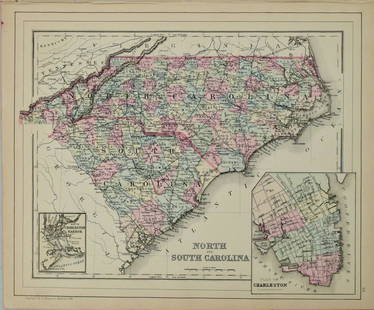
Sold20191867 NORTH + SOUTH CAROLINA MAPOriginal antique map of North and South Carolina published by S. Augustus Mitchell, Jr. Includes inset maps of Charleston Harbor in the bottom left and a Plan of Charleston in the bottom right. It feaSee Sold Price
Sold2016Map of Maryland, Virginia, North & South CarolinaTitle: Map of Maryland, Virginia, North Carolina and South Carolina Maker: S. Augustus Mitchell Date: 1878 No Reserve: This lot starts at $1 and has no reserve as a courtesy so that collectors can detSee Sold Price
Sold2016S. Mitchell: North and South Carolina, 1871Map: North and South Carolina Cartographer: S Mitchell Publishing: Philadelphia, 1871 (marked 1850) Size: 11.3 x 14 inches A very nice map of the Carolinas, showing via color-coding the individual couSee Sold Price
Sold2023Emanuel Bowen Map North & South Carolina, Georgia[Emanuel Bowen Map of North & South Carolina and Georgia] , "A New & Accurate Map of the Provinces of North & South Carolina Georgia & c. Drawn from late Surveys and regulated by Astron Observat. By ESee Sold Price
Sold2017Bradford: Antique Map of North/South Carolina & GeorgiaTitle/Content of Map: North & South Carolina with Georgia by Bradford Date Printed: 1835 Cartographer: T.G. Bradford Material/Medium: Paper Size: 13" x 9 1/2" A Comprehensive Atlas Geographical, HistoSee Sold Price
Sold20211796 MAP OF NORTH & SOUTH CAROLINA, DENISON, FRAMEJ. Denison (American, 18th century). "Map of North and South Carolina" -1796, from "Morse's Universal Geography", engraving. Framed. Provenance: From the Lifetime Collection of Billy S. Arant, Jr., ChSee Sold Price
Sold2016Map of North & South Carolina, 1868Original engraving from Johnson's Atlas of the World, 1868. Map includes vignette of the Charleston Harbor & details cities, towns and territories. Dimensions: 18" x 26". This item ships from Ocean ViSee Sold Price
5 days LeftJasper521775-1780 North & South Carolina, Georgia and Virginia. By Bonne & Raynal$160(1 bid)
1 day LeftTrillium Antique Prints & Rare BooksKohler & Weigel - Map of the World with North and South Pole views$130(2 bids)
2 days LeftRoyal Treasures Warehouse LLC1530s Old Map of the World as seen from the North & South Poles$50
5 days LeftJasper52Large Oil Painting Lake District Crummock Water by William Mitchell of Maryport$4,000
Featured6 days LeftJasper52Northern & Southern Africa. Maghreb. Orange River Sovereignty. HALL 1856 map$20
Jun 07Holabird Western Americana CollectionsBonneville's Rocky Mountain Adventure Map 1849 [178900]$350
BonhamsMITCHELL (SAMUEL AUGUSTUS) A New Universal Atlas Containing Maps of the Various Empires, Kingdom...£1,300
6 days LeftJasper52Coste Occidentale d’Afrique…' West Africa. Gulf of Guinea. BELLIN 1746 map$55
Featured6 days LeftJasper52Coste Orientale d’Afrique…' East Africa Kenya Tanzania Somalia. BELLIN 1746 map$80


![Emanuel Bowen Map North & South Carolina, Georgia: [Emanuel Bowen Map of North & South Carolina and Georgia] , "A New & Accurate Map of the Provinces of North & South Carolina Georgia & c. Drawn from late Surveys and regulated by Astron Observat. By E](https://p1.liveauctioneers.com/268/293228/155705053_1_x.jpg?height=310&quality=70&version=1687296979)


![Early California Map c1856 [179290] (1 of 1)](https://p1.liveauctioneers.com/2699/331495/178785754_1_x.jpg?height=282&quality=70&version=1717094933)


![Heart of the Alleghanies Book c1883 [181016] (1 of 7)](https://p1.liveauctioneers.com/2699/331494/178785458_1_x.jpg?height=282&quality=70&version=1717107891)


![South & Central America Map Lot c1800's [180163] (1 of 5)](https://p1.liveauctioneers.com/2699/331495/178785795_1_x.jpg?height=282&quality=70&version=1717094933)


![Bonneville's Rocky Mountain Adventure Map 1849 [178900] (1 of 2)](https://p1.liveauctioneers.com/2699/331495/178785771_1_x.jpg?height=282&quality=70&version=1717094933)


