Sold20201855 Johnston World Map with Comperative Chart ofTitle/Content: 1855 Johnston World Map with Comperative Chart of Rivers and Mountains -- The World in Hemispheres, with Comparative Views of the Heights of ths Principal Mountains and Lengths of the PSee Sold Price
Sold2017Rand McNally: Antique World Map, Rivers & MountainsMap: Rand McNally World Map and Comperative Chart of Rivers and Mountains -- The World on Mercator's Projection [verso] Western Hemisphere Cartographer: Rand McNally Year / Place: 1898, Chicago Map DiSee Sold Price
Sold20201855 Johnston Chart of Air Currents, Trade Winds andTitle/Content of Map: 1855 Johnston Chart of Air Currents, Trade Winds and Hurricanes -- Geographical Distribution of the Currents of Air or the Perennial Periodical and Variable Winds , Showing alsoSee Sold Price
Sold20201855 Johnston Map of Cultivation Zones of Cereal Crops,Title: 1855 Johnston Map of Cultivation Zones of Cereal Crops, Spices, Coffee and Sugar -- Survey of the Geographical Distridution and Cultivation of the Most Important Plants which are Used as Food fSee Sold Price
Sold20211855 Johnston Map of Ireland -- IrelandTitle: 1855 Johnston Map of Ireland -- Ireland Cartographer: AK Johnston Year / Place: 1855, Edinburgh Map Dimension (in.): 24 X 19.9 in. This is a large and highly detailed map of Ireland. Great dealSee Sold Price
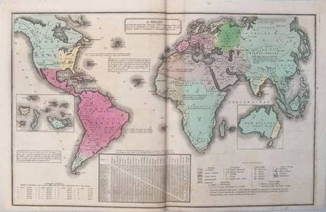
Sold20211835 Smith World Map -- A Chart Exhibiting the ActualTitle: 1835 Smith World Map -- A Chart Exhibiting the Actual and Comparative Size of each Country, Nation, or Kingdom; its Population as a Whole and to a Square Mile. Also the Different States of SociSee Sold Price
Sold2017Chart of the World on Mercators ProjectionCirca 1796 Lot of 2 Antique World Maps; Titles: "Chart of the World on Mercators Projection" (Doolittle, sculp.) Approximate size: 11" x 8-3/8". "Map of the World from the best Authorities" (DoolittleSee Sold Price
Sold2017Smith: Antique Map of the World, 1835Map: 1835 Smith World Map -- A Chart Exhibiting the Actual and Comparative Size of each Country, Nation, or Kingdom; its Population as a Whole and to a Square Mile. Also the Different States of SocietSee Sold Price
Sold2024William Hole "A Description of the land of Gosen, and Moses passage though the Deserts"Map from Raleigh's History of the world 1652. This map charts the legendary journey of Moses, leading the Israelites out of Egyptian captivity. It depicts their escape route, including the dramatic paSee Sold Price
Sold2020The Second World WarOne of the most comprehensive accounts of the Second World War. Contains maps, charts, copies of correspondence, lists of meeting and a vast array of relative information." Publishers black cloth withSee Sold Price
Sold20231821 Woodbridge Thematic World Map -- Moral and Political Chart Of The Inhabited World ...Title: 1821 Woodbridge Thematic World Map -- Moral and Political Chart Of The Inhabited World ... Cartographer: W. Woodbridge Year / Place: 1831, Hartford Map Dimension (in.): 8.2 X 10.8 in. This is aSee Sold Price
Sold20191859 Beeton Chronological Chart with World Map -- AnTitle/Content of Map: 1859 Beeton Chronological Chart with World Map -- An Historical Chronological Chart with inset of The World in Mercators Projection Date: 1859 c., London Cartographer: S Beeton SSee Sold Price
Sold20231758 Map Chart of World TradewindsAn Accurate Chart of the World with the New Discoveries....Tradewinds.., by Thomas Kitchin, 1758. Large folding map, measures 17 x 13", Condition issues including creasing and repaired breaks at foldsSee Sold Price
Sold20201855 Savage World Geography History MAPS Coins Commerce1855 Savage World Geography History MAPS Coins Commerce Native American INDIANS Charles Savage’s ‘The World, Geographical, Historical, and Statistical’ is a mid-19th-century account of the histoSee Sold Price
Sold2022AJ Nystrom 2-Sided Chalkboard School Map, US & WorldLarge AJ Nystrom Roll Up 2 Sided Chalkboard Classroom Map Chart, US & World. Wonderful chart has maps of the United States and the World outlined in yellow on a black chalkboard backing. From the RoyaSee Sold Price
Sold20211821 Woodbridge Thematic World Map -- Moral andTitle: 1821 Woodbridge Thematic World Map -- Moral and Political Chart Of The Inhabited World ... Cartographer: W. Woodbridge Year / Place: 1831, Hartford Map Dimension (in.): 8.2 X 10.8 in. This is aSee Sold Price
Sold2021Colton’s Map of the World - 1855Nice example of Colton's Map of the World from the first edition of Colton’s Atlas of the World. Shows the routes of numerous 18th and 19th Century explorers, including Cook, Furneaux, Vancouver, thSee Sold Price
Sold20191821 Chart of the World Map This is a mercator'sThis is a mercator's projection of North America by John Purdy, published Jan 1, 1821 by Richard Holmes Laurie, measures 40" wide by 26.5" tall.See Sold Price
Sold2023The Mountain Systems of Europe. JOHNSTON 1856 old antique map plan chartTITLE/CONTENT OF MAP: 'The Mountain Systems of Europe' DATE PRINTED: 1856 IMAGE SIZE: Approx 53.5 x 63.0cm, 21 x 24.75 inches (Large); Please note that this is a folding map. TYPE: Antique map with orSee Sold Price
Sold2023Perry, Matthew 1856 Large Map. Chart of the World. Track of the U.S Steam Ships"Chart of the World showing the Track of the U. S. Steam Frigates Mississippi, Susquehanna, and Powhatan" Large Folio Lithograph Map Published 1856, Washington for "Narrative of the Expedition of an ASee Sold Price
Sold2023Thomson, John (Pub) 1825 Map. Chart of the WorldCopper Engraved Map Published 1825 by John Thomson, Edinburgh for "The Edinburgh School Atlas" by N. R. Hewitt. Maps Engraved by Hewitt. Original Outline Hand Colour. Rare. Paper Size: 10.5 x 8 inch (See Sold Price
Sold2021Thomson, John (Pub) 1825 Map. Chart of the WorldCopper Engraved Map Published 1825 by John Thomson, Edinburgh for "The Edinburgh School Atlas" by N. R. Hewitt. Maps Engraved by Hewitt. Engraved Vignette in corner. Original Outline Hand Colour. RareSee Sold Price
Sold2023Russell & Barclay 1832 Hand Col Map. Chart of the WorldHand Colored Steel Engraved Map Published 1823-40, by Fisher & Son, "A Complete Atlas of the World" by John Russell et al. A Very Rare Work which is compiled from the same plates used in different ediSee Sold Price
Sold2023Russell & Barclay C1825 Antique Map. Chart of the World (On Mercator Proj.)Copper Engraved Map Published C1825., by Fisher & Son, "A Complete Atlas of the World" by John Russell et al. The companion Atlas to "A Complete and Universal English Dictionary" by James Barclay. PapSee Sold Price
6 days LeftJasper521833 Woodbridge World Map -- Map of the World Adapted to Woodbridge's Geography$40
2 days LeftTrillium Antique Prints & Rare BooksDobson - Map of the World with Chart of Torrid Zone or Tropical Regions of the World$50
Featured6 days LeftJasper521875, Brooklyn Bridge under Construction, Prospect Part, sites in the Holy Land. By Hardesty$20
6 days LeftJasper52Scenes in Rome and the Vatican, Entrance to the Taj Mahal, temples in India and Thailand. By$20


![Rand McNally: Antique World Map, Rivers & Mountains: Map: Rand McNally World Map and Comperative Chart of Rivers and Mountains -- The World on Mercator's Projection [verso] Western Hemisphere Cartographer: Rand McNally Year / Place: 1898, Chicago Map Di](https://p1.liveauctioneers.com/5584/108569/55677982_1_x.jpg?height=310&quality=70&version=1504123318)