Sold20201844 World MapTitle: 1844 World Map Author: Mitchell Medium: Ink on Paper Dimensions: 12"X14" Description: World map dated 1844. Engraved and published by Augustus Mitchell in "Mitchell's Ancient Geography". This mSee Sold Price
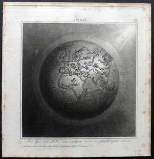
Sold2019Rhind, William 1844 Rare Map of the Old World. EarthAquatint Map Published 1844, London "The Creation: Illustrated By Six Engravings On Steel" by William Graeme Rhind. Rare. Paper Size: 6.5 x 6 inch (16.5 x 16cm) Very minor margin toning, slightly affeSee Sold Price
Sold20211844 Mitchell's Ancient Atlas Map Book,Hand ColoredAntique Geography Book, Mitchell's Ancient Atlas 1844. A school instructional book "Containing Maps Illustrating Geography of the Ancient World". Published in Philadelphia by E.H. Butter & Co. DimensSee Sold Price
Sold2020Johnston Map of U.S. 1844*** START PRICE IS THE RESERVE *** [America] JOHNSTON, Alexander Keith (1804-1871). United States and Texas. Lithograph with original color. London, 1844. 21 1/8" x 26 1/8" sheet. Comparable: Old WorlSee Sold Price
Sold2022Antique 1844 Hand Colored Olney's School Atlas Published by Pratt, Woodford, and Co.This is an antique Olney's School Atlas published in 1844 by Pratt, Woodford and Co of New York. The softbound volume features hand colored maps of regions of the United States and the world. CharmingSee Sold Price
Sold2016T-O World Map.- Lucanus (Marcus Annaeus) Pharsalia,Lucanus (Marcus Annaeus) Pharsalia, manuscript on paper, [Northern Italy (possibly Padua), first half of the fifteenth century]. 294 x 217mm., I + 149 + I leaves (including defective leaves and 3 blanSee Sold Price
Sold2024Petrus Plancius, Engraved World MapOrbis Terrarum Typus de Integro Multis in Locis Emendatus. Petrus Plancius (1552-1622). Copper-plate engraving with original hand color in full. Amsterdam, 1594. Some stains, creases, folds. Sight sizSee Sold Price
2022Blaeu, Johannes (Netherlands, 1596-1673) "The New World Map" Double Hemisphere World Map C. 1664Nova et Accuratissima Totius Terrarum Orbis Tabula Translated "The New World Map", Hand Colored w/ Elaborately Decorated Spandrels.   Sight View 16" x 21-1/2", Overall View 21" x 25-1/2"See Sold Price
Sold2018Ortelius' 1570 world mapHeading: Author: Ortelius, Abraham Title: Typus Orbis Terrarum Place Published: Antwerp Publisher: Date Published: 1570-[1584?] Description: Copper-engraved map, hand-colorSee Sold Price
2018Important World Map from the Nuremberg Chronicle, 1493Title/Content of Map: World Map from the Nuremberg Chronicle. One of the most important world Maps ever produced Date Printed: 1493 Cartographer: Hartmann Schedel Material/Medium: Paper Size: 18" x 25See Sold Price
Sold2023A Witco Tiki Art World MapWorld Map mixed media sculpture mid century modern Witco 37.25 x 62.25 inches Overall very good condition.See Sold Price
Sold2017World mapWorld map 'Nova Totius Terraum Orbis Geographica Ac Hydrographica Tabula', copper engraving map of Heinrich Hondius, dated 1630,two hemispheres the world map, surrounded by rich allegorical representaSee Sold Price
Sold2020Mercator World Map*** START PRICE IS THE RESERVE *** [World] MERCATOR, Rumold (1545-1599). Orbis Terrae Compendiosa Descriptio Quam ex Magna Universali Mercatoris... Engraved Map with original hand color. Geneva, 1587.See Sold Price
Sold2022Massive World Map Custom-Made Coffee Table 1995One of a kind, all iron and custom glass work, signed in 1995. Aprox. Weight: 200 lbs -Measurements: 65 in L x 40 in x 23 in HSee Sold Price
Sold2016Beautifully Colored Jan Van Loon World MapOrbis Terrarum Nova... Jan Van Loon (c. 1611-1686). Engraved map with original hand color in full. London: Moses Pitt, 1680. 17 3/4 x 21 inches visible, 28 1/4 x 31 3/4 inches framed. A fine example oSee Sold Price
Sold2016Celebrated 16th Century World Map by Abraham OrteliusTypvs Orbis Terrarvum, Antwerp, dated 1587, with hand-coloring; Spanish text on the back credits the cartographer's sources in this updated edition showing the Solomon Islands and a corrected South AmSee Sold Price
Sold2017FRAMED WORLD MAP BY HERMAN MOLL, 1719'A New & Correct Map of the Whole World, by Herman Moll, Geographer, 1719.' Hand tinted and framed. Frame size: 73 x 124 cm (28 3/4 x 48 3/4 in.)See Sold Price
Sold2023Mercator, Rumold (1545-1599) World MapAn engraved double-page double hemispheric world map, "Orbis Terrae Compendiosa Descriptio". Dimensions:Sight is 11 1/4" x 20 3/4", the frame 21" x 29 1/2". Provenance:From a Philadelphia Collection.See Sold Price
Sold2022World.- Bordone (Benedetto di) [World Map], woodcut, [1522].World.- Bordone (Benedetto di) [World Map], early map showing the recent developments in cartography and departing from Ptolemaic models, including open water between the two continents and not joininSee Sold Price
Sold2021Oyvind Fahlstrom, Sketch for World Map, ScreenprintArtist: Oyvind Fahlstrom, Swedish (1928 - 1976) Title: Sketch for World Map Portfolio: Peace Year: 1972 Medium: Screenprint, Signed and numbered in pencil Edition: 150 Size: 33 in. x 41.5 in. (83.82 cSee Sold Price
Sold2024Coronelli's elegant two-sheet hemispheric world map[MAP - WORLD] CORONELLI, VINCENZO MARIA. Planisfero Del Mondo Vecchio; [and] Planisfero Del Mondo Nuovo. [Venice: circa 1691]. Two hand-colored engraved hemispheric world maps printed on separate sheeSee Sold Price
Sold2016[World Map]. Rumold Mercator. Orbis terrae compe[World Map]. Rumold Mercator. Orbis terrae compendiosa descriptio.&See Sold Price
Sold2018Coronelli World MapCORONELLI, Vicenzo (1650-1718). Planisfero del Mondo Nuovo, Descritto… Copperplate Engraving. Venice, 1691. 19 1/2 x 28 inches sheet, 28 x 37 inches framed Italy’s Greatest 17th Century Map Maker.See Sold Price
Sold2020Zahn World Map*** START PRICE IS THE RESERVE *** [World] ZAHN, Johann (1631-1707). Facies Una Hemispaerri Terrestris and Facies Altera Hemishpaerii Tarrastris... Double hemishperic world map on two engraved sheets.See Sold Price
20 hrs LeftJasper521833 Woodbridge World Map -- Map of the World Adapted to Woodbridge's Geography$40
20 hrs LeftJasper521881 Vuillemin World Map with French Colonies Shown -- Planisphere: Indiquant les Colonies Francises$30
3 days LeftActivity AuctionsRare 1976**Franklin Mint*Sterling Silver**925/Gold World Map Old Art Piece$1,100
5 days LeftWorthington Galleries19th c. Hemisphere World Map, Hohen und Tiefen der Erde in Lambert’s Zenithal-Projection von$10
2 days LeftJasper52NIGERIA w/ early explorers' routes. Lake Chad Yariba Houssa Borgou.SDUK 1844 map$60
Jun 15Fine Arts OutletYoung Couple Reviewing a World Map Bronze Statue - Size: 32"L x 47"W x 42"H.$3,150
Jun 13Swann Auction Galleries(WORLD.) Group of 6 eighteenth-century engraved double-hemispheric world maps.$900


![Johnston Map of U.S. 1844: *** START PRICE IS THE RESERVE *** [America] JOHNSTON, Alexander Keith (1804-1871). United States and Texas. Lithograph with original color. London, 1844. 21 1/8" x 26 1/8" sheet. Comparable: Old Worl](https://p1.liveauctioneers.com/1968/163248/82424588_1_x.jpg?height=310&quality=70&version=1583340284)

![T-O World Map.- Lucanus (Marcus Annaeus) Pharsalia,: Lucanus (Marcus Annaeus) Pharsalia, manuscript on paper, [Northern Italy (possibly Padua), first half of the fifteenth century]. 294 x 217mm., I + 149 + I leaves (including defective leaves and 3 blan](https://p1.liveauctioneers.com/5458/94966/48431616_1_x.jpg?height=310&quality=70&version=1476369049)


![Ortelius' 1570 world map: Heading: Author: Ortelius, Abraham Title: Typus Orbis Terrarum Place Published: Antwerp Publisher: Date Published: 1570-[1584?] Description: Copper-engraved map, hand-color](https://p1.liveauctioneers.com/642/127929/65081054_1_x.jpg?height=310&quality=70&version=1537227236)


![Mercator World Map: *** START PRICE IS THE RESERVE *** [World] MERCATOR, Rumold (1545-1599). Orbis Terrae Compendiosa Descriptio Quam ex Magna Universali Mercatoris... Engraved Map with original hand color. Geneva, 1587.](https://p1.liveauctioneers.com/1968/163248/82424686_1_x.jpg?height=310&quality=70&version=1583340284)


![World.- Bordone (Benedetto di) [World Map], woodcut, [1522].: World.- Bordone (Benedetto di) [World Map], early map showing the recent developments in cartography and departing from Ptolemaic models, including open water between the two continents and not joinin](https://p1.liveauctioneers.com/5458/252576/131355887_1_x.jpg?height=310&quality=70&version=1655911671)

![Coronelli's elegant two-sheet hemispheric world map: [MAP - WORLD] CORONELLI, VINCENZO MARIA. Planisfero Del Mondo Vecchio; [and] Planisfero Del Mondo Nuovo. [Venice: circa 1691]. Two hand-colored engraved hemispheric world maps printed on separate shee](https://p1.liveauctioneers.com/292/326828/175962847_1_x.jpg?height=310&quality=70&version=1713473479)
![[World Map]. Rumold Mercator. Orbis terrae compe: [World Map]. Rumold Mercator. Orbis terrae compendiosa descriptio.&](https://p1.liveauctioneers.com/906/93415/47683584_1_x.jpg?height=310&quality=70&version=1473203012)

![Zahn World Map: *** START PRICE IS THE RESERVE *** [World] ZAHN, Johann (1631-1707). Facies Una Hemispaerri Terrestris and Facies Altera Hemishpaerii Tarrastris... Double hemishperic world map on two engraved sheets.](https://p1.liveauctioneers.com/1968/163248/82424687_1_x.jpg?height=310&quality=70&version=1583340284)


